
Tennessee, Alabama and Mississippi Face 85% Tornado Probability Monday as Two High-Risk Zones Target the Mid-South
MEMPHIS, Tennessee — Two separate zones of dangerous severe weather are taking shape for Monday, April 27, and Tennessee, Alabama, and Mississippi are sitting directly in the crosshairs. Tornado probability values are climbing as high as 85% across parts of the Mid-South — a signal that this could be one of the more significant severe weather days of the spring season.
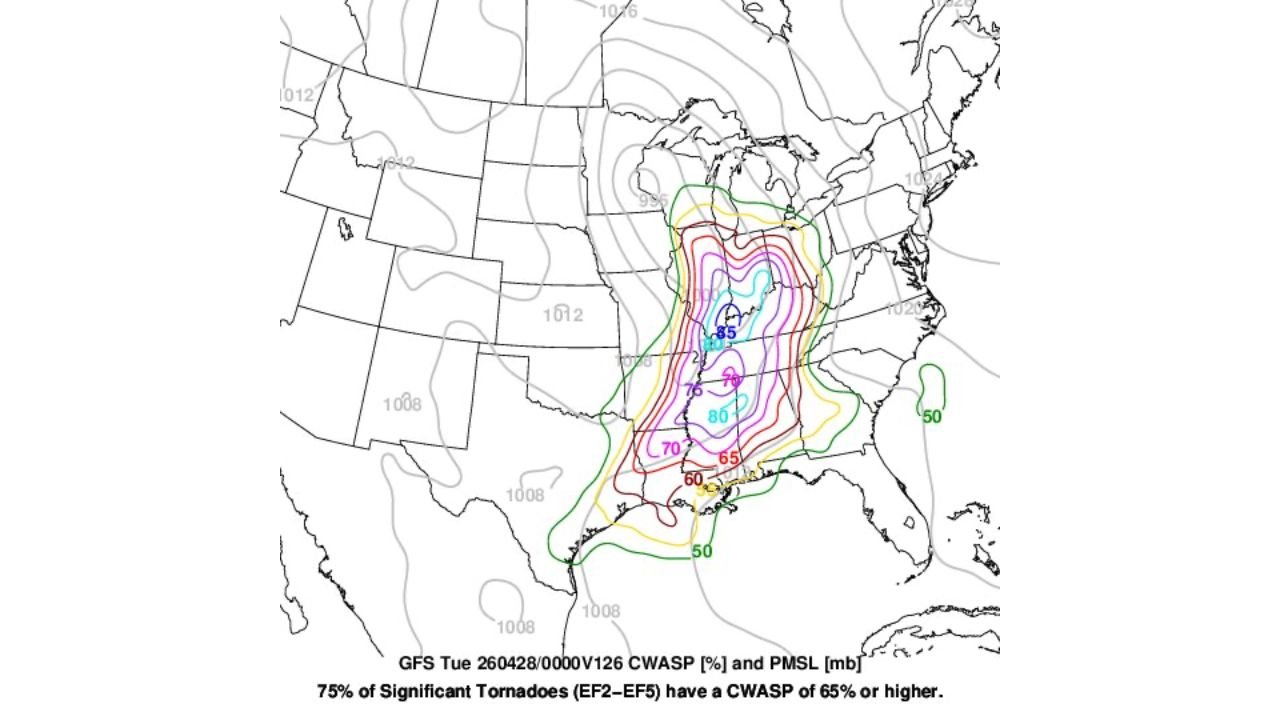
The atmospheric setup is generating two distinct high-risk corridors, both showing values above the 80+ threshold where significant, long-track tornadoes become a serious concern.
States and Cities in the Risk Zone
- Tennessee: Memphis, Nashville — northern high-risk zone centered here, CWASP values hitting 85%
- Alabama: Birmingham, Huntsville, Tuscaloosa — southern high-risk zone showing 80% values; second bull’s-eye targets this corridor
- Mississippi: Jackson, Tupelo — caught between both zones, elevated threat throughout the day
- Kentucky: Paducah, Bowling Green — inside the outer 70–76% contours
- Georgia: Atlanta northern suburbs — sitting inside the 60–65% zone
- Indiana and Illinois: Southern portions inside the 50% outer ring — cannot be ruled out
Primary Threats
- Significant tornadoes (EF2–EF5) — CWASP values above 65% mean 75% of all significant tornadoes historically occur in this type of setup; values here reach 85%
- Two separate high-risk zones — northern bull’s-eye centered over Tennessee, southern bull’s-eye targeting Alabama and Mississippi simultaneously
- Damaging straight-line winds — both zones carry major wind damage potential alongside the tornado threat
- Large hail — expected with supercell development across the entire corridor from Kentucky to Alabama
Why This Matters for Tennessee and Alabama
Tennessee and Alabama have both experienced a quieter-than-normal spring so far — but Monday is where that changes, and it could change dramatically. A CWASP value of 85% over Memphis and the surrounding region is not a routine number. To put it plainly: this is the kind of atmospheric fingerprint that shows up on the worst tornado days on record across the Mid-South.
Birmingham and Huntsville in Alabama sit inside the southern high-risk zone where values reach 80% — nearly as high as the northern peak. Having two separate zones this strong on the same day means there is no single safe corner of the state to retreat to. Both zones are capable of producing EF2 or stronger tornadoes.
Mississippi is sandwiched between the two bull’s-eyes, meaning Jackson and Tupelo face a prolonged severe weather threat as storm systems move through from the west. Storm mode — whether storms organize into discrete supercells or a squall line — will be the critical factor in determining exactly how bad Monday gets. Both modes carry serious threats.
Multi-Day Pattern
Monday’s event does not come out of nowhere. The broader pattern has been loading up energy across the Southern Plains and Gulf Coast states through the weekend, and the trigger arrives Monday as a strong atmospheric disturbance pushes east. The two high-risk zones are expected to be active from afternoon through the overnight hours — meaning nighttime tornado warnings are a real possibility for Alabama and Mississippi.
After Monday, the pattern does not completely relax. Additional storm rounds are possible Tuesday and into mid-week before a brief lull, but Monday carries the highest concentrated threat of the near-term period.
What to Watch Next
- Confirm your tornado shelter plan today — do not wait until Monday morning
- Charge all devices and make sure wireless emergency alerts are enabled on every phone in your household
- Monday storms could arrive after dark across parts of Alabama and Mississippi — nighttime tornadoes are the most deadly
- Watch for storm mode updates — supercell vs. squall line will shape exactly where the worst threats land
- If CWASP values hold or increase in Sunday updates, this event could be upgraded to a higher formal risk level
Residents across Tennessee, Alabama, and Mississippi should treat Monday, April 27 as a serious severe weather day and have their plans locked in before the weekend is over.
WaldronNews.com will continue tracking this developing threat and provide updates as Monday’s storm timing and risk zones become clearer.