
Tennessee, Mississippi and Alabama Face EF2+ Tornado Risk Monday as Supercells Target Memphis to Paducah Corridor
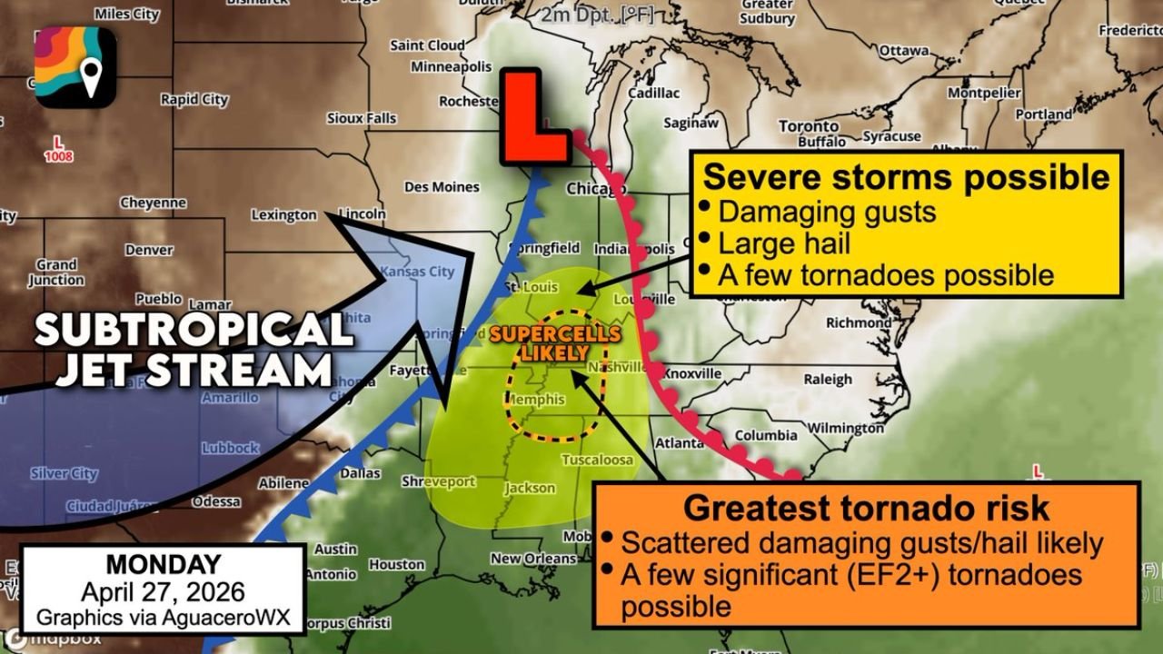
MEMPHIS, Tennessee — Monday, April 27 is shaping up to be a dangerous severe weather day across the Deep South and Mid-Mississippi Valley, with rotating supercells expected to bring EF2 or stronger tornadoes, scattered damaging wind gusts, and large hail to a corridor stretching from Memphis, Tennessee through Paducah, Kentucky — a zone that has emerged as the highest-confidence target for significant severe weather.
A powerful subtropical jet stream roaring overhead combined with a surging low-pressure system pulling warm, humid air north is creating the perfect fuel for rotating thunderstorms across Tennessee, Mississippi, Alabama, and into Illinois and Indiana.
States and Cities in the Risk Zone
Greatest Tornado Risk Zone:
- Tennessee: Memphis, Nashville, Tuscaloosa corridor — supercells likely; EF2+ tornadoes possible
- Mississippi: Jackson, Tupelo — scattered damaging gusts and hail likely; significant tornado threat
- Alabama: Birmingham, Tuscaloosa — inside the greatest tornado risk zone; dangerous overlap with supercell corridor
- Kentucky: Paducah, Louisville — Memphis-to-Paducah corridor consistently flagged as highest risk
Severe Storms Possible Zone:
- Illinois: Chicago, Springfield — damaging gusts, large hail, a few tornadoes possible
- Indiana: Indianapolis — severe storms possible as system pushes east
- Ohio: Cincinnati, Louisville metro — on the eastern fringe of the severe threat
- Georgia: Atlanta, Knoxville area — tornado risk extends into the Southeast
Primary Threats
- EF2+ significant tornadoes — the Memphis to Paducah corridor is the highest-confidence zone; a few strong, long-track tornadoes cannot be ruled out
- Rotating supercells — the subtropical jet stream overhead is loading the atmosphere with wind shear, the key ingredient that makes thunderstorms spin into tornadoes
- Scattered damaging wind gusts — both inside the tornado zone and across the broader severe storm corridor
- Large hail — likely with supercell development across Tennessee, Mississippi, and Alabama through the day and into the night
Why This Matters for Tennessee and Mississippi
Memphis and the surrounding Mid-Mississippi Valley have been called out specifically as the zone where the atmospheric setup is most consistent and most dangerous. Here is what is happening: a low-pressure system sitting somewhere over the Upper Midwest or Great Lakes is pulling a surge of warm, humid air north from the Gulf of Mexico. At the same time, the subtropical jet stream is blasting wind shear through the mid and upper levels of the atmosphere.
When thunderstorms build tall enough to reach those high-altitude winds, the changing wind direction with height causes the storms to rotate. That rotation is what creates supercells — and supercells are what produce the strongest, most dangerous tornadoes.
Mississippi and Alabama have had a relatively quiet severe weather season so far this spring. That quiet ends Monday. The atmosphere is not just slightly unstable — it is loaded. Forecasters are confident that ample instability will be in place across the Deep South, and the only remaining uncertainty is exactly where the low tracks and how individual storm modes evolve.
Multi-Day Pattern
Monday’s event is the product of a large-scale atmospheric pattern that has been building all week. The cold front arriving from the west will trigger storms that blossom along and ahead of it through the afternoon and evening. Because the setup supports organized supercells rather than a simple squall line, the threat could persist well into Monday night — making this a dangerous overnight severe weather situation for parts of Alabama and Mississippi.
The details will sharpen in the 24–48 hours before the event. The broad threat is locked in, but storm timing, exact track of the surface low, and whether discrete supercells hold together before merging into a line will all shape where the worst impacts land.
What to Watch Next
- The Memphis to Paducah corridor is the highest priority zone — residents in this area should finalize shelter plans immediately
- Monday storms are likely to continue after dark across Alabama and Mississippi — nighttime tornadoes are the deadliest
- Watch Sunday forecast updates closely — storm mode details will become clearer within 24 hours
- Make sure every phone in your home has wireless emergency alerts turned on right now
- Know the difference between a Tornado Watch (conditions favorable) and a Tornado Warning (tornado detected or imminent) — and know where you are going the moment a warning is issued for your county
Residents across Tennessee, Mississippi, Alabama, and Kentucky should not wait until Monday morning to prepare — the time to act is now.
WaldronNews.com will continue tracking this developing severe weather threat and provide updates as Monday’s forecast continues to take shape.