
North Carolina, South Carolina and Georgia Had Zero Tornado Warnings in 30 Days While Illinois and Indiana Shattered Records
CHARLOTTE, North Carolina — Something highly unusual has been happening across the Carolinas and the Southeast this April — and the numbers make it impossible to ignore. Through April 21, 2026, not a single tornado warning has been issued across North Carolina, South Carolina, Georgia, or Alabama. Zero. In a region where spring thunderstorms are as reliable as the calendar itself, an entire month without a tornado warning is rare enough to stop and examine.
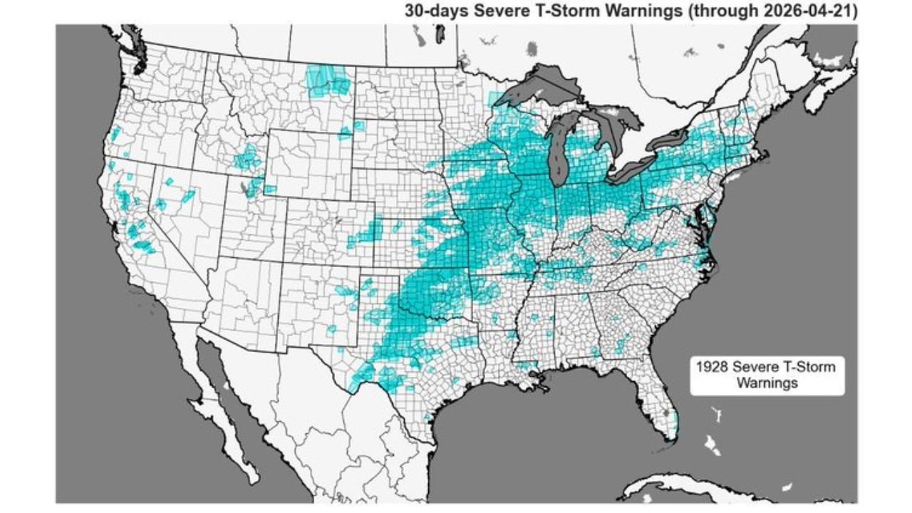
Meanwhile, the Midwest — specifically Illinois, Indiana, Iowa, and Wisconsin — has been absorbing one of the most active severe weather stretches in recent memory, with 380 tornado warnings issued nationally over the past 30 days and the overwhelming majority concentrated in a tight bull’s-eye over the Great Lakes corridor.
States by the Numbers
Where the storms have been — well above normal:
- Illinois and Indiana: Tornado warning probability anomaly sitting at the deepest red on the scale — far above historical averages for this period
- Wisconsin and Michigan: Elevated tornado warning counts, multiple severe thunderstorm warnings
- Iowa and Minnesota: Above-normal severe storm activity through mid-April
- Ohio and Pennsylvania: Slightly above normal; caught in the active corridor’s eastern edge
Where the storms have not been — well below normal:
- North Carolina: Zero tornado warnings; severe thunderstorm warning activity far below normal (deep blue anomaly)
- South Carolina: Same story — historically quiet for April
- Georgia: Below-normal severe weather across the entire state
- Alabama and Mississippi: Tornado warning anomaly running significantly below average
- Tennessee: Below normal — quiet stretch that is about to end
- Louisiana and Florida: Suppressed severe weather activity throughout April
Primary Threats — What the Data Reveals
- 1,928 severe thunderstorm warnings issued nationally over the past 30 days — but almost none across the Deep South or Carolinas
- 380 tornado warnings issued nationally — with the Illinois/Indiana bull’s-eye absorbing the heaviest concentration
- The Southeast’s 30-day severe storm probability anomaly is running 0.6 to 0.8 below normal — one of the deepest negative anomalies on the map
- The Midwest’s tornado warning anomaly is running 0.8 to 1.0 above normal in the core zone — the darkest red category
Why This Matters for the Carolinas and Southeast
Here is the simple explanation for what has been happening: the atmospheric pattern over the past 30 days has consistently delivered storm energy to the Midwest while keeping a dome of dry, stable air locked over the Southeast. For Charlotte, Raleigh, Columbia, and Atlanta, that has meant no thunder, no severe weather watches, and an April that has felt more like late summer than peak tornado season.
That is genuinely unusual. The Carolinas sit in one of the most tornado-active regions east of the Mississippi during spring. Going through the entire first three weeks of April without a single tornado warning is the kind of anomaly that stands out even to experienced forecasters — and it is being noticed.
The drought connection matters too. The Southeast has been running dry for weeks, and drought conditions suppress the low-level moisture that severe thunderstorms need to develop. No moisture, no storms. That relationship has held through April — but it is beginning to break down.
Multi-Day Pattern
The pattern that kept the Southeast quiet is flipping. The same data showing a historic calm across North Carolina, Georgia, and Alabama for the past 30 days is now showing a loaded atmosphere ready to make up for lost time. The Deep South is about to see its first significant severe weather stretch of the spring, with multiple storm rounds expected starting late this week and continuing through the first two weeks of May.
For the Midwest, which has already absorbed far more than its share of severe weather this month, a brief calmer period is possible — but the overall active pattern for the region is not done. The Illinois/Indiana corridor that has been ground zero for tornado warnings may see some relief as storm energy shifts south.
What to Watch Next
- North Carolina and South Carolina — the quiet ends soon; first meaningful severe weather threat of April arrives this weekend and next week
- Georgia and Alabama — the 30-day drought of tornado warnings is about to be replaced by multiple active storm days; prepare now
- Illinois and Indiana — brief relative lull possible, but remain alert as the overall pattern stays unsettled
- Track moisture return across the Gulf Coast states — when humidity surges north, the Southeast severe weather season officially restarts
- The contrast between a 30-day anomaly this extreme and a sudden pattern flip means the atmosphere has stored up energy — the first active stretch could be more significant than a typical spring event
Residents across North Carolina, South Carolina, Georgia, and Alabama should recognize that the unusual calm of April does not mean severe weather season has passed — it means it is just beginning.
WaldronNews.com will continue tracking this pattern shift and provide updates as the Southeast’s long-quiet severe weather season roars back to life.