
Virginia, Maryland and Pennsylvania Drought Gets Quarter-Inch Relief This Weekend but 10 Inches Needed to Truly Recover
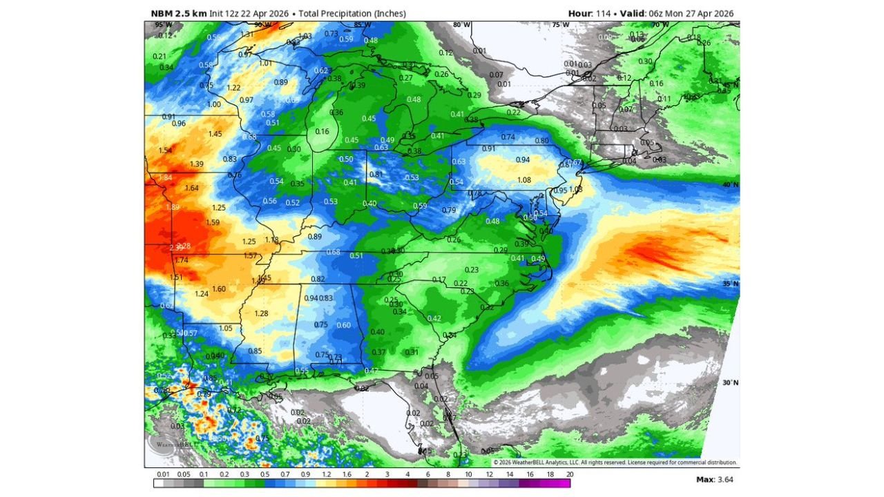
WASHINGTON, D.C. — A cold front pushing through Virginia, Maryland, Pennsylvania, and the broader Mid-Atlantic this weekend will bring the first meaningful rain chance in weeks — but do not mistake light relief for a drought fix. Most areas from Washington, D.C. through Philadelphia and Richmond are expected to pick up around a quarter of an inch, and while any rain is welcome after the prolonged dry stretch, reversing the drought gripping this region would require 10 or more inches over a sustained period.
The front arrives late Saturday with impacts continuing into Sunday, marking the beginning of a gradual pattern shift that could bring more consistent rain chances into next week.
States in the Weekend Rain Zone
- Virginia: Richmond, 0.22–0.36 in.; Northern Virginia corridor, 0.39–0.50 in. — light but welcome rainfall
- Maryland: Baltimore, Washington D.C. metro, 0.48–0.54 in. — slightly better totals along the I-95 corridor
- Pennsylvania: Philadelphia, 0.50–0.95 in.; Pittsburgh area, 0.78–0.81 in. — among the better totals in the region
- New Jersey: 0.91–1.08 in. — highest totals on the map for the immediate Mid-Atlantic
- West Virginia: 0.48–0.63 in. across central areas
- North Carolina: Scattered light amounts, 0.17–0.34 in. — far less coverage than states to the north
- Kentucky and Tennessee: 0.25–0.42 in. across portions — light and spotty
Primary Threats
- Drought relief is minimal — the quarter-inch most areas receive this weekend barely scratches the surface of a deficit that would need 10+ inches to meaningfully reverse
- Scattered thunderstorms possible alongside the showers Saturday night and Sunday — not a major severe weather event, but isolated storms cannot be ruled out
- Timing uncertainty remains for next week’s follow-up rain chances — coverage and amounts still unclear but signals exist for additional rainfall
- Pattern shift underway — this weekend’s system is the opening act of a wetter stretch, not a one-and-done event
Why This Matters for Virginia and Maryland
Washington, D.C., Richmond, and the Northern Virginia suburbs have been running dangerously dry. April has brought almost no meaningful rainfall to the Mid-Atlantic, and the drought footprint has been expanding steadily. Gardens, reservoirs, and agricultural operations across Virginia and Maryland are all feeling the stress.
The rain arriving this weekend lands in that frustrating middle ground — enough to briefly green things up and settle the dust, but nowhere near enough to make a real difference underground where it counts. Soil moisture deficits built over weeks of dry weather do not reverse with a quarter inch. To put the scale of the problem in perspective: 10 inches of rain over a sustained period is what forecasters indicate would be needed to truly reverse drought conditions — and this weekend delivers roughly 2 to 4 percent of that.
The more important story is what comes after. This weekend’s front appears to be the first nudge in a pattern that gradually opens the door to more rain chances heading into late April and early May. Pennsylvania and New Jersey are positioned to see the best totals this round, with some spots approaching or exceeding 1 inch — more meaningful but still not drought-busting.
Multi-Day Pattern
The front sweeps through late Saturday night and exits by Sunday, leaving behind lingering clouds and the possibility of a few additional showers. Rainfall totals through Monday morning show the Mid-Atlantic corridor picking up the most, with the precipitation shield concentrated from Pennsylvania through New Jersey and the DC metro.
Looking into next week, additional rain chances are signaled but the details are still being worked out. Timing and coverage remain uncertain — what is clear is that the pattern is shifting away from the nearly rainless stretch that has dominated the Southeast and Mid-Atlantic through most of April. Whether next week’s rain amounts to another light event or something more substantial will become clearer in the next 48–72 hours.
What to Watch Next
- Track rainfall totals through Sunday — New Jersey and southeastern Pennsylvania have the best chance of seeing close to or above 1 inch
- Virginia and North Carolina should temper expectations — coverage is lighter and totals will likely fall below a quarter inch in many spots
- Watch Monday and Tuesday forecasts for next round of rain chances — timing shifts could bring better totals than this weekend
- Drought conditions will not improve meaningfully until a multi-day soaking event arrives — this weekend is not that event
- Residents on well water or with fire-sensitive properties across Virginia and Maryland should remain cautious despite the incoming rain
Any rain at this point is a step in the right direction for Virginia, Maryland, and the broader Mid-Atlantic — but the drought recovery story is just beginning, not ending, this weekend.
WaldronNews.com will continue tracking rainfall totals and drought conditions across the Mid-Atlantic and provide updates as next week’s rain chances come into focus.