
Washington D.C. Just Logged Its Warmest April Since 1872: Now 15 Days of 80-Degree Heat Give Way to a Cold Snap That Lasts Through May
WASHINGTON, D.C. — The record books in Washington D.C. are being rewritten in real time — and then slammed shut. The nation’s capital has hit 80 degrees or higher on 15 separate days so far in 2026, shattering the previous record of 13 days set back in 1976 and running nearly three times the historical average of five such days through this point in the year. April 2026 is running as the second-warmest April on record in D.C. dating back to 1872, and the city has been running 6 degrees above average for the month.
Now it all stops. A cold pattern is establishing itself from Monday through at least May 6 that puts the entire Mid-Atlantic, Northeast, and Mid-South below normal — and the record warm pace that defined D.C.’s spring is almost certainly finished.
How Historic This Warm Stretch Actually Was
The numbers deserve a moment of context before the cold arrives. 15 days at or above 80°F before the end of April is not just a record in Washington D.C. — it is nearly double what any year in the modern observational record has produced at this point in the calendar. The previous record of 13 days was set 50 years ago in 1976. The average through late April is just 5 days. What D.C. experienced in 2026 represents a warm anomaly so large it sits in a category essentially by itself in the historical data going back 154 years.
April specifically has been running 6 degrees above the monthly average — a deviation that, sustained over an entire month, is climatologically extraordinary. The period since March 1 ranks as the third-warmest March-through-April stretch in records beginning in 1872, meaning only two other springs in a century and a half have started as warm as this one.
The Cold That Follows — Monday Through May 6
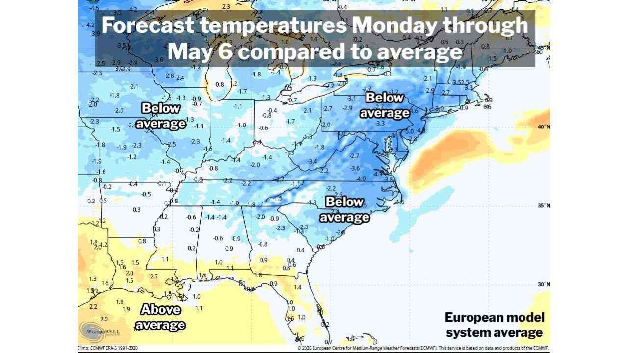
The temperature anomaly map covering Monday through May 6 shows blue essentially everywhere from the Great Plains to the Atlantic Coast. Every major city in the Mid-Atlantic, Northeast, and Mid-South is forecast to run below normal for this entire period:
- Washington D.C.: -3.3 to -4.0°F below normal through the period — the warmest April in modern memory gives way directly to a below-normal early May
- New York and New England: -2.7 to -3.5°F below normal — the Northeast transitions from warmth to cold with essentially no transition period
- North Carolina and Virginia: -2.3 to -3.6°F below normal — Raleigh and Charlotte, already deep in drought, now face below-normal temperatures alongside the moisture deficit
- Ohio and Pennsylvania: -2.0 to -3.4°F below normal — Cleveland and Pittsburgh in the colder anomaly zone
- Tennessee and Kentucky: -1.4 to -2.2°F below normal — Nashville and Memphis both running cooler than average
- Illinois and Indiana: -1.0 to -2.0°F below normal — the Midwest joins the below-normal pool
The only areas holding above normal during this period are portions of the Deep South Gulf Coast — Louisiana, Mississippi, and Alabama — where +1.0 to +2.7°F anomalies persist as the active storm pattern keeps warmer Gulf air pushing north ahead of frontal systems.
Why the Record Pace Ends Here
The atmospheric pattern that produced D.C.’s record warm stretch was driven by a persistent ridge of high pressure that kept cold air locked in Canada and warm air flowing north along the East Coast. That ridge is collapsing as the Greenland and Alaska high-pressure blocking pattern — described in the broader early May forecast — takes over and forces the jet stream to buckle southward.
Once the jet stream drops south, it acts as a conveyor belt delivering Canadian air into the Mid-Atlantic repeatedly through early May. There is a brief window next week where temperatures may rebound slightly — but forecasters are explicit that hitting 80°F again appears unlikely. The era of consecutive warm days in D.C. is over for now, and the cool pattern appears durable enough to hold through at least the first week of May.
What This Means Beyond Just Temperature
The cold arriving after an exceptionally warm April creates some specific concerns beyond simple comfort. Gardens and landscaping across Virginia, Maryland, and D.C. that responded aggressively to the record warmth — putting out early growth, early flowers, and in some cases early fruit tree blossoms — are now exposed to below-normal temperatures for an extended period. Late frost risk, while not extreme for the D.C. metro specifically, is real for the Shenandoah Valley and western Virginia where elevation and cold air pooling can push temperatures to damaging levels even when D.C. stays safely above freezing.
The drought connection also matters here. Below-normal temperatures slow evapotranspiration — the rate at which soil loses moisture — which is marginally helpful for the Severe Drought already gripping the region. But cooler temperatures alone cannot fix a deficit measured in inches. The drought requires rain, not just cold, to recover.
The Record That Stands — For Now
15 days at or above 80°F through late April in Washington D.C. is a record that may stand for a very long time. Records set during individual months or seasons tend to be more durable than annual records because they require such a specific combination of persistent atmospheric patterns. The 1976 record of 13 days stood for 50 years. The 2026 record of 15 days has a similar potential for longevity — because producing this many warm days this early requires an atmospheric setup that is genuinely rare even in a warming climate.
The spring of 2026 in Washington D.C. will be remembered as one of the warmest ever recorded — immediately followed by one of the more abrupt transitions to a cold early May in recent memory.
WaldronNews.com will continue tracking temperature trends across the Mid-Atlantic and provide updates on frost risk and drought conditions as the cold pattern establishes itself through early May.