
Illinois, Missouri and Tennessee Stare Down a Higher-End Tornado Outbreak Monday as Chicago, St. Louis and Memphis All Fall Inside the 30% Enhanced Risk
CHICAGO, Illinois — The severe weather machine that spent the weekend tearing through Oklahoma and Kansas is not finished. It is reorganizing, reloading, and pointing directly at the Midwest and Mid-South for Monday, April 27 — and the data is now serious enough that forecasters are explicitly flagging a higher-end severe weather and tornado outbreak as a realistic outcome.
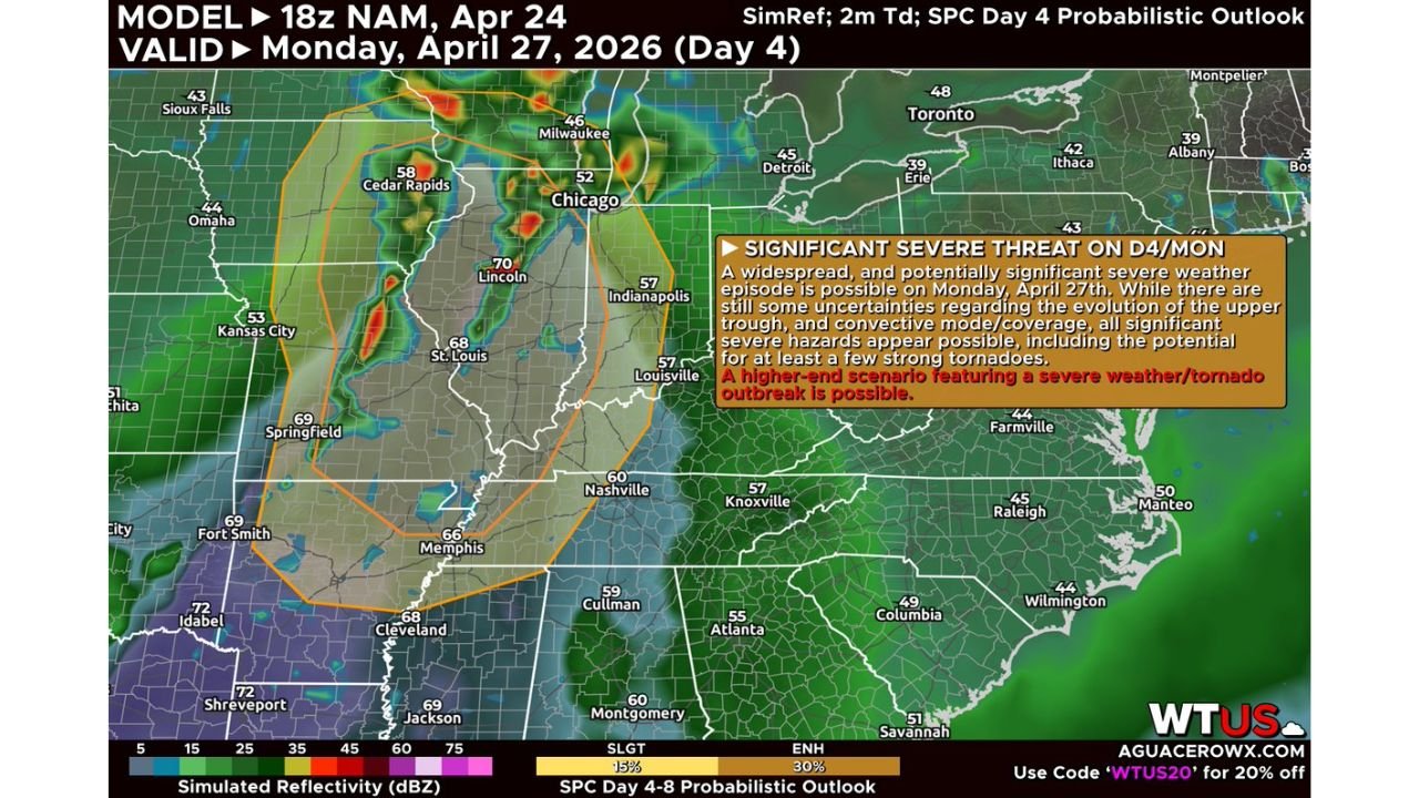
A 30% Enhanced Risk corridor on the Day 4 probabilistic outlook covers a striking lineup of major cities: Chicago, Milwaukee, Cedar Rapids, Lincoln, St. Louis, Indianapolis, Louisville, Nashville, and Memphis — all inside a high-CAPE, high-shear environment where robust supercells will be capable of very large hail, damaging winds, and EF2+ tornadoes.
The 30% Enhanced Corridor — Biggest Cities in the Crosshairs
The orange 30% probability zone on Monday’s NAM simulation stretches from Iowa and Wisconsin south through Illinois, Missouri, and Tennessee into Mississippi and Arkansas. This is not a fringe risk for these cities — they are named directly on the model output:
- Illinois: Chicago (dewpoint 58°F), Lincoln (70°F) — two of the deepest moisture readings on the entire map sitting inside the core threat zone
- Wisconsin: Milwaukee (46°F) — northern fringe of the 30% corridor
- Iowa: Cedar Rapids (58°F) — inside the enhanced risk
- Missouri: St. Louis (68°F), Springfield (69°F), Kansas City (53°F) — St. Louis and Springfield deep inside the warm sector with high moisture
- Indiana: Indianapolis (57°F), Louisville (57°F) — both cities in the threat zone
- Tennessee: Nashville (60°F), Memphis (66°F) — southern extension of the enhanced risk; Memphis dewpoints among the highest on the map
- Mississippi: Jackson (69°F), Shreveport (72°F) — deepest moisture values on the entire simulation; southern anchor of the outbreak zone
- Arkansas: Fort Smith (69°F) — inside the warm sector core
Sunday’s Storms Will Shape Everything That Happens Monday
This is the piece that makes Monday uniquely difficult to forecast. Sunday’s Oklahoma supercell outbreak — itself a PDS-level event — will leave behind a complex landscape of storm boundaries, outflow zones, and modified air masses that Monday’s storms will have to navigate.
Storm boundaries from Sunday act like invisible rails in the atmosphere. They can focus Monday’s supercell development in unexpected locations, accelerate storm rotation when supercells cross them, or in some cases disrupt the warm sector enough to weaken storm development. Whether Sunday’s leftovers help or hurt Monday’s tornado threat depends on exactly where those boundaries end up — and that is still too uncertain to call four days out.
What forecasters are confident about is the large-scale setup. The upper trough, surface low, and warm front positioning are all consistent across model runs in showing a high-CAPE, high-shear environment across a broad warm sector from Iowa to Mississippi on Monday. The details — exactly how far north the warm front pushes, how fast the trough moves, whether storms stay discrete or merge — will determine whether Monday is a significant outbreak or a historic one.
What High-CAPE, High-Shear Means for Every City on This List
The NAM simulation surface dewpoints tell the moisture story. Memphis at 66°F, St. Louis at 68°F, Springfield Missouri at 69°F, Jackson Mississippi at 69°F, Shreveport at 72°F — these are Gulf Coast-level moisture readings sitting hundreds of miles inland. That moisture is the raw fuel that turns wind shear into violent rotating storms.
When that fuel meets the upper trough moving in from the west, the result is rapid storm development across a wide area. Every supercell that forms in this environment has immediate access to instability and shear that supports EF2 or stronger tornadoes. The phrase forecasters are using — “wherever robust supercells form and mature” — means the threat is not confined to one track or one city. It follows wherever the strongest storms organize.
For Chicago and Milwaukee, this represents an unusually direct severe weather threat for a Monday in late April. Both cities are inside the 30% corridor with dewpoints in the mid-to-upper 40s — not as deep as the southern moisture but sufficient for significant severe weather when the shear values from Monday’s upper trough arrive overhead.
The Outbreak Scenario That Forecasters Are Watching
The explicit language in the forecast text is worth noting: “a higher-end scenario featuring a significant severe weather/tornado outbreak is possible.” That phrasing does not appear in routine severe weather outlooks. It reflects a setup where the atmospheric parameters are loaded enough that, if storm mode cooperates and the warm sector is not disrupted by Sunday’s activity, the event could produce widespread significant tornadoes across multiple states simultaneously.
The corridor from St. Louis through Nashville to Memphis is the zone where this scenario is most plausible. Missouri and Tennessee have not been at the center of a major tornado outbreak this spring — and Monday may end that streak decisively.
Three Things Still Unknown That Determine How Bad Monday Gets
The warm front’s northward reach — if the warm front pushes further north than models suggest, the highest instability and shear could overlap over Chicago and Milwaukee rather than staying centered over St. Louis. This would shift the most dangerous zone northward.
Trough timing and amplitude — a slower, deeper trough produces more wind shear and a more prolonged severe weather window. A faster, shallower trough produces a shorter but still dangerous event. This difference alone could separate a 4-hour tornado threat from a 10-hour one.
Sunday’s storm remnants — outflow boundaries left by Sunday’s Oklahoma supercells could either focus Monday’s tornado threat into a tighter, more intense zone or disrupt the warm sector enough to weaken storm development in some areas.
What Monday Looks Like From Where You Live
Chicago and Milwaukee — you are inside the 30% corridor. This is not a peripheral risk. Have a plan that does not involve being on the highway or in an upper-floor office during Monday afternoon and evening severe weather.
St. Louis and Springfield, Missouri — the deepest moisture values on the map combined with your position inside the enhanced risk make Monday a serious event. Monday evening could bring tornado-warned storms to the metro area.
Nashville and Memphis, Tennessee — both cities are named on the model output inside the threat zone. Memphis dewpoints are among the highest on the map. Southern Tennessee sits at the overlap of the deepest moisture and the incoming shear — one of the more dangerous locations for Monday.
Jackson, Mississippi and Shreveport — the absolute deepest moisture values on Monday’s map are here. If the warm sector holds intact this far south, storms tracking through these areas will have more fuel than anywhere else in the outbreak zone.
The window to prepare is this weekend. Use it.
WaldronNews.com will provide daily updates on Monday’s developing outbreak through the weekend as model confidence increases and the threat zone sharpens.