
Oklahoma Faces PDS Tornado Emergency Sunday as 4,000-5,000 CAPE and STP Values Above 8 Signal Potentially Violent Long-Track Twisters
OKLAHOMA CITY, Oklahoma — The sounding data coming out of Oklahoma for Sunday is generating the kind of numbers that make experienced meteorologists stop and stare. A Particularly Dangerous Situation (PDS) tornado setup is taking shape across Oklahoma for Sunday afternoon and evening — the highest and most serious tornado classification that forecasters issue. With surface CAPE values between 4,000 and 5,000+ J/kg, Storm Relative Helicity at -329 m²s², Significant Tornado Parameter values climbing above 8, and a Differential Heating Boundary positioned to focus discrete supercell development, this is not a standard severe weather day. This is a setup that produces violent, long-track tornadoes.
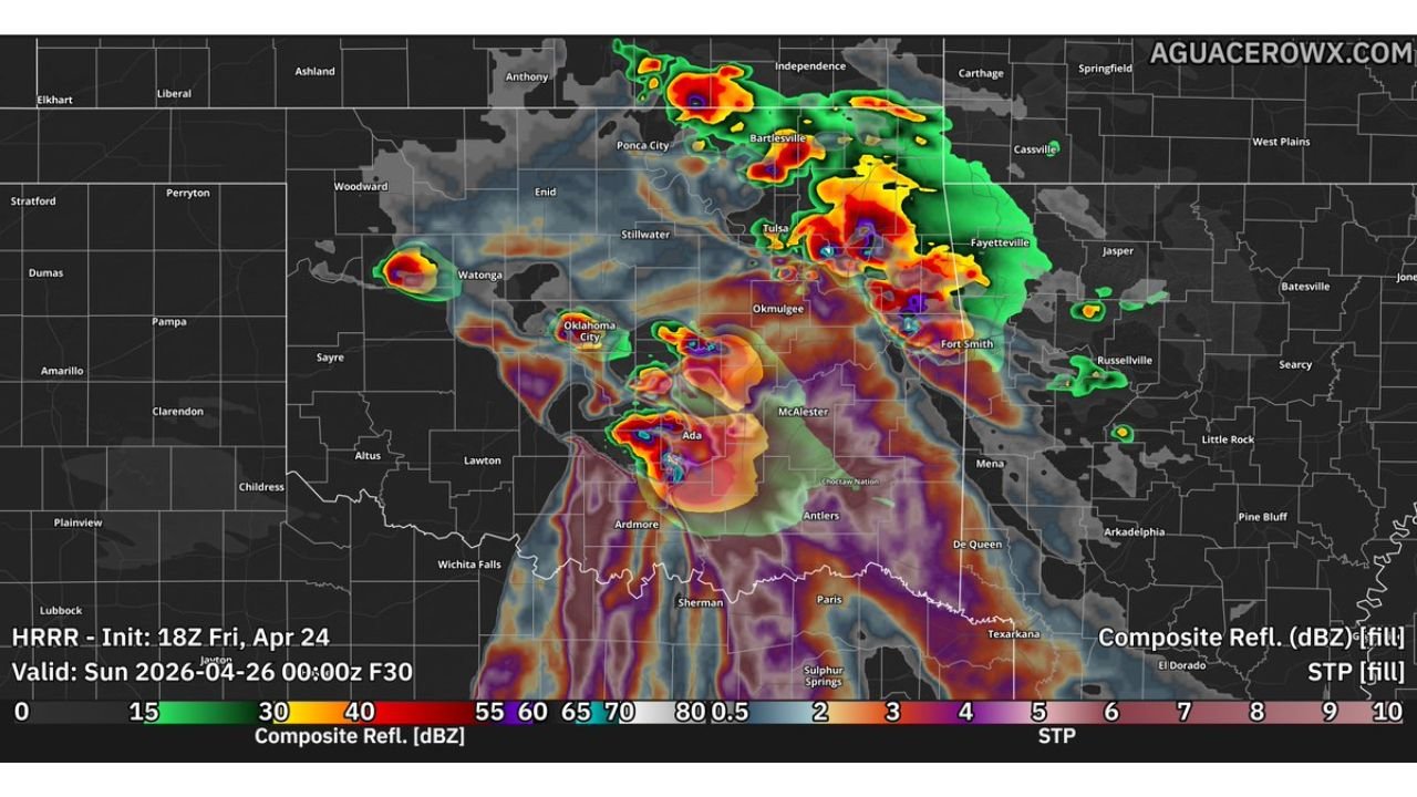
The HRRR model simulation valid Sunday evening shows multiple intense supercell cores firing across Oklahoma City, Ada, Tulsa, Bartlesville, and tracking east into Fort Smith, Arkansas — each surrounded by the deep purple STP shading that represents the most extreme tornado parameter values on the scale.
What the Sounding Data Is Actually Saying
The atmospheric sounding plotted for Saturday evening near the Oklahoma-Texas border — the air mass that feeds into Sunday’s storms — reads like a checklist for violent tornado production. Every single parameter is in the upper tier:
- Surface CAPE: 528 J/kg at the surface, mixed-layer CAPE at 4,804 J/kg — extraordinary instability; storms will be explosive and tall
- Storm Relative Helicity: -329 m²s² — deep, powerful rotation available in the lowest levels of the atmosphere; this number directly correlates to tornado intensity
- STP (Significant Tornado Parameter): 34.3 at the surface level — values above 1 are considered significant; values above 8 on the map represent the highest-end tornado environments; 34.3 is an extreme outlier
- SHIP (Significant Hail Parameter): 4.9 — large hail alongside the tornado threat
- Effective Shear: 249/17 kt at the 4-6km layer — deep-layer shear supporting organized, long-lived supercells
- Critical Angle: 106 degrees — near-ideal for streamwise vorticity, meaning the wind turning in the low levels is oriented almost perfectly to feed rotation into storm updrafts
- LCL height: 328m — extremely low cloud base; low LCLs dramatically increase the probability that a rotating updraft produces a tornado at the surface
- SARS analog classification: PDS TOR — the computer sounding analog system, which compares this profile to historical significant tornado events, flags this as a Particularly Dangerous Situation
The EF-scale probability distribution shown on the sounding output gives a probability of EF2+ tornadoes with a supercell — and the box plot shows the distribution extending well into EF4+ territory based on the STP and ESRH values.
The DHB Factor — Why This Boundary Changes Everything
A Differential Heating Boundary is forming across Oklahoma on Sunday — a subtle surface boundary created by differences in soil moisture, cloud cover, and temperature across the landscape left behind by Friday’s storms. These boundaries are invisible on standard weather maps but are among the most powerful tornado focusing mechanisms in existence.
When a supercell encounters or develops along a DHB, several things happen simultaneously. The boundary provides extra convergence that tightens and strengthens the storm’s updraft. It adds low-level vorticity — pre-existing spin in the atmosphere near the ground — that a storm can immediately ingest and amplify into tornado-producing rotation. And it slows storm motion in some cases, giving tornadoes more time over any given location.
Historically, some of the most violent and longest-track tornadoes on record in Oklahoma have been produced by supercells that latched onto exactly this type of boundary in a similar atmospheric environment. If Sunday’s supercells find and ride the DHB, the tornado threat escalates from significant to potentially historic.
Where the HRRR Is Showing the Highest Threat
The radar simulation for Sunday evening paints a concerning picture for multiple Oklahoma cities simultaneously. Intense supercell cores — shown in the deep red and purple colors indicating maximum reflectivity and highest STP values — are clustered across:
- Oklahoma City and surrounding metro — a supercell core sits directly over the city in the simulation; given the STP values in this area, any storm tracking through the OKC metro would be an immediate life-threatening emergency
- Ada and McAlester — southern Oklahoma shows a separate intense core with extremely high STP values surrounding it; this is inside the deepest instability pool
- Tulsa, Bartlesville, Ponca City — northern Oklahoma supercells tracking toward Kansas and Missouri with high STP values extending through this corridor
- Fort Smith, Arkansas and Fayetteville — storms tracking east bring the threat into northwest Arkansas by evening
The One Variable That Keeps This Conditional
Despite all the extreme numbers, forecasters are careful to label this as conditional. Two factors could lower the threat:
Crosswise vorticity in the low levels — if the wind structure near the ground produces more crosswise rather than streamwise vorticity, storms rotate less efficiently and tornadoes become less likely even with high CAPE and SRH values.
Storms too close to each other — if multiple supercells fire simultaneously and cluster together, they compete for the same warm moist inflow air. When storms cannibalize each other’s fuel supply, they weaken and the discrete supercell structure that produces the most violent tornadoes breaks down into a messier, less organized system.
If discrete supercells hold together and ride the DHB, the ceiling on Sunday’s event is very high. If storms cluster and interact, the tornado threat drops and the primary hazard becomes damaging winds.
The Difference Between This and a Normal Severe Weather Day
Oklahoma sees hundreds of severe weather days per year. PDS tornado setups — the kind that generate this sounding profile — happen perhaps two to four times per decade. The combination of STP above 8, SRH approaching -330, CAPE above 4,000, critical angle near 106 degrees, and LCL heights below 400 meters all occurring simultaneously in the same air mass is extraordinarily rare.
The SARS sounding analog system — which searches a historical database of thousands of soundings to find the closest matches — returned no quality matches for the supercell category. That means Sunday’s atmospheric profile is unusual enough that the historical database cannot find a close parallel. When the computer cannot find a comparable day in its records, that is a signal that the atmosphere is operating in a rare and dangerous regime.
Every Second of Preparation Before Sunday Afternoon Counts
- The Oklahoma City metro is inside the highest-risk zone — a PDS tornado event in an urban area of over 1 million people is a mass casualty scenario if residents are not in shelter during warnings
- Ada, McAlester, and Ardmore in southeast Oklahoma sit inside the deepest instability pool with the highest STP values on the map — these communities face direct exposure
- Tulsa and Bartlesville are in the northern supercell corridor — treat Sunday with the same urgency as OKC
- Fort Smith and Fayetteville, Arkansas should be on full alert by Sunday evening as storms track east
- Do not be in a vehicle, manufactured home, or any structure without a reinforced interior room during Sunday afternoon and evening — PDS tornado events produce the tornadoes that destroy well-built homes
Sunday’s setup over Oklahoma has the atmospheric fingerprint of one of the most dangerous tornado days of the decade. Every hour before storms fire is an hour to prepare.
WaldronNews.com will provide continuous updates on Sunday’s PDS tornado threat across Oklahoma as the event develops.