
Nashville and Middle Tennessee’s Drought-Weakened Trees Face Monday Night Wind Threat as QLCS Targets the I-65 Corridor
NASHVILLE, Tennessee — Monday’s severe weather story for Middle Tennessee has shifted and in some ways the shift makes it more insidious, not less dangerous. The significant tornado outbreak that was once possible for Nashville has become less likely as the overall storm system has slowed down significantly. What remains is a strong Quasi-Linear Convective System a QLCS, or fast-moving squall line developing out of Arkansas and Missouri and tracking east into Middle Tennessee Monday night into early Tuesday morning.
For most cities, a QLCS instead of discrete supercells would be considered good news. For Nashville, it is complicated because the trees across Middle Tennessee are already structurally compromised from the lingering effects of a recent ice storm and months of drought stress. Half the city has already lost power from a weaker, more disorganized storm line. A strong QLCS hitting those same weakened trees Monday night is a serious power outage and property damage scenario even without a single tornado.
What Three Atmospheric Maps Are Showing for the I-65 Corridor
The Euro model’s Friday 06Z run backed by ensemble support is consistent across three separate atmospheric layers in identifying the same corridor: a zone running along and west of I-65 through Middle Tennessee as the area most favorable for QLCS maintenance and damaging wind production Monday night.
The Lapse Rate Map — Why Storms Stay Alive Here
The 500-700mb lapse rate map shows a corridor of 7-8+ J/kg instability values highlighted in the teal box running through west-central Tennessee. This corridor represents the zone where the atmosphere between roughly 10,000 and 18,000 feet is unstable enough to keep a squall line energized as it moves east. West of this corridor, the atmosphere is more stable and storms weaken. East of I-65, the lapse rates drop off and the QLCS begins losing steam. The window of maximum storm maintenance and therefore maximum wind threat runs through the highlighted zone west of the interstate.
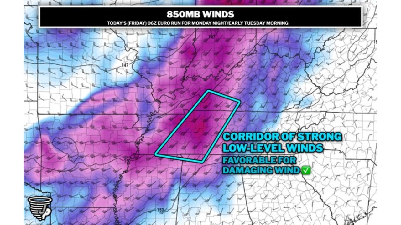
The 850mb Wind Map — Where Damaging Winds Are Most Likely
The low-level wind map at 850mb shows deep purple and magenta shading indicating very strong winds at roughly one mile above the surface exactly the level that QLCS systems tap into and bring down to the ground as damaging straight-line wind gusts. The teal box again identifies a corridor of strong low-level winds in the same west-of-I-65 zone through Middle Tennessee. When a squall line moves through an area with this wind profile, it acts like a pump pulling those strong elevated winds down to the surface in powerful gusts capable of snapping branches, toppling already-stressed trees, and taking down power lines.
The Surface Dewpoint Map — Moisture That Keeps the Engine Running
Surface dewpoints in the 61-68°F range are shown ahead of and within the storm line across the Middle Tennessee corridor. This moisture is the fuel that keeps the QLCS from collapsing prematurely as it tracks east. The forecaster notes this is “still favorable for damaging wind potential” meaning even though the storm mode is a line rather than discrete supercells, the moisture supply is sufficient to keep it strong and organized through the Nashville region before it weakens east of I-65.
The Ice Storm and Drought Tree Problem
This is the factor that separates Middle Tennessee’s Monday night threat from a standard squall line event. Nashville and surrounding counties are entering this event with a significantly compromised urban forest. The ice storm that hit earlier this season added weight stress and caused structural cracking in thousands of trees across the metro. Months of drought then stressed the same trees through their root systems, reducing their ability to anchor effectively in soil that has shrunk and dried around the root ball.
The result is a landscape full of trees that look healthy from the outside but are far more vulnerable to wind loading than they would be under normal conditions. A 45 to 55 mph wind gust entirely achievable in a well-organized QLCS with this low-level wind profile can topple drought-stressed trees that would have survived the same gust a year ago. The forecaster makes this point explicitly: half the city has already lost power from a weaker, relatively disorganized line of storms. A stronger, better-organized QLCS Monday night hits the same compromised tree canopy.
The Tornado Question — Still Not Zero West of I-65
QLCS systems are capable of producing brief, spin-up tornadoes particularly where the line interacts with surface boundaries or where the low-level wind shear is locally enhanced. The slowing of Monday’s overall system reduces but does not eliminate the tornado risk. The same corridor west of I-65 that is most favorable for QLCS maintenance is also the zone where brief embedded supercells or line segments could produce a quick tornado with very little warning time.
QLCS tornadoes are among the most dangerous in terms of lead time they often form in seconds as a bowing segment in the line rotates, giving residents sometimes less than two minutes between a warning and the tornado passing. This is particularly concerning for a Monday overnight event when most residents will be asleep.
East of I-65 — The Threat Drops But Does Not Disappear
Murfreesboro, Smyrna, Lebanon, and communities east of the interstate are in a better position than western Nashville suburbs. The models consistently show the QLCS losing steam after crossing I-65 as lapse rates drop and the low-level wind corridor weakens. That said, a QLCS that is strong enough to produce damaging winds west of the interstate will still bring gusty winds, lightning, and heavy rain east of it just at a lower intensity. No part of Middle Tennessee gets a completely quiet Monday night.
Before Monday Evening — Specific Steps for Nashville Residents
- Look at the trees around your home right now any large limbs already cracked, split, or hanging from the ice storm are projectiles in a 50 mph wind event Monday night
- If you have a vehicle parked under a large tree, move it before Monday evening drought-stressed trees can drop entire limbs without significant wind loading
- Charge all devices before bed Monday this event arrives overnight and power outages could last into Tuesday
- Do not assume the tornado threat is completely gone QLCS spin-up tornadoes west of I-65 are possible with very short warning times; know where your interior shelter is before you go to sleep
- West Nashville, Bellevue, Dickson County, Hickman County, and communities along the I-40 corridor west of the city face the highest wind threat and should be most alert
Nashville has already shown this spring that even a disorganized storm line can take the city’s lights out. Monday night’s QLCS is better organized than that event. Take it seriously.
WaldronNews.com will continue tracking Monday night’s QLCS threat across Middle Tennessee and provide updates through the day Monday as storm timing and intensity become clearer.