
Kansas and Missouri Jump to Enhanced Risk Sunday as Wichita, Tulsa and Oklahoma City Enter the Outbreak Zone
WICHITA, Kansas — Sunday’s severe weather threat across the Central Plains has been upgraded to an Enhanced Risk (Level 3 of 5) covering portions of Kansas and Missouri, with Wichita sitting directly inside the orange core zone. A strong atmospheric trough and a highly favorable severe weather environment are locked in place across the Plains for Sunday, capable of producing strong tornadoes, very large hail, and damaging winds. The only remaining question is whether storms can break through and initiate. If they do, forecasters are explicit that this setup could quickly escalate into a high-end outbreak.
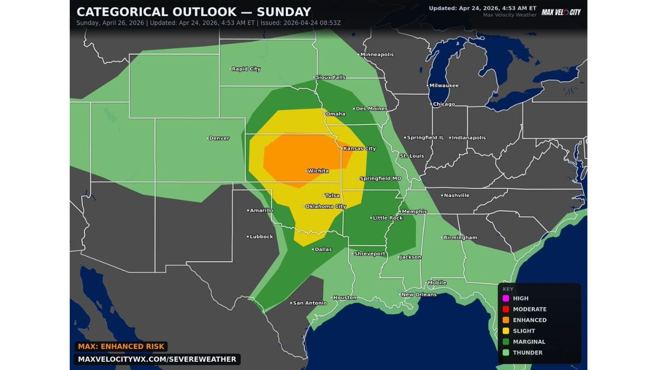
The orange Enhanced Risk zone covers Wichita, Tulsa, Oklahoma City, Kansas City, and Springfield, Missouri. Every one of those cities faces all severe hazards Sunday if storms fire as expected.
The Outbreak Map City by City
The orange Enhanced Risk core is the highest category on Sunday’s outlook and covers a concentrated corridor through the heart of the Central Plains:
Orange Enhanced Risk — Strong Tornadoes, Very Large Hail, Damaging Winds:
- Kansas: Wichita, Kansas City — both cities directly inside the Enhanced zone
- Oklahoma: Tulsa, Oklahoma City — two of the largest cities in the region sitting inside the core threat
- Missouri: Springfield — eastern anchor of the Enhanced Risk corridor
Yellow Slight Risk — All Severe Hazards Possible:
- Nebraska: Omaha, Sioux Falls fringe — northern spread of the threat
- Missouri: Kansas City — on the boundary between Slight and Enhanced
- Arkansas: Little Rock — southern extension of the Slight Risk
- Texas: Dallas, Amarillo area — outer fringe of the severe weather zone
Green Marginal Risk — Severe Storms Possible:
- Minnesota: Minneapolis — far northern fringe
- Illinois: Springfield IL, Chicago area — eastern edge
- Tennessee: Memphis, Nashville — southeastern fringe
- Texas: Lubbock, San Antonio, Houston corridor — southern extension
- Louisiana: Shreveport, New Orleans area
A Strong Trough and a Loaded Atmosphere
The atmospheric setup driving Sunday’s threat is built around a strong upper-level trough digging into the Central Plains from the northwest. This trough is providing the upper-level wind shear that makes thunderstorms rotate into supercells and the large-scale lifting that forces storms to develop even where the atmosphere might otherwise resist.
Below that trough, the surface environment is described as highly favorable. Warm, humid Gulf moisture is surging northward through Oklahoma and Kansas, loading the warm sector with the instability that gives thunderstorms their explosive vertical growth. When that moisture-laden surface air meets the wind shear from the approaching trough, the result is an atmosphere primed for organized, long-lived supercells.
The one variable keeping this from being a guaranteed outbreak is storm initiation. A cap may resist storm development in some locations, particularly across central Oklahoma where capping has been the story all week. But across Kansas and into Missouri, the cap is weaker and storm initiation is more confident. That is why Wichita and Kansas City sit inside the Enhanced Risk while locations further south carry slightly lower categorical risk.
Why Wichita and Tulsa Cannot Treat This as Background Noise
After a week of consecutive severe weather days across the Plains, there is a real risk of alert fatigue setting in across Kansas and Oklahoma. Residents who survived Thursday’s TOR:CON 5 event and Saturday’s softball hail day may be tempted to treat Sunday as just another entry on a long list of threatening forecasts. That would be a mistake.
Sunday’s Enhanced Risk designation is based on a genuinely dangerous atmospheric setup that stands on its own merits, independent of the week’s earlier events. The trough driving Sunday’s storms is a fresh system with its own energy, not a weakened remnant of earlier activity. Wichita sits at the center of the Enhanced Risk for the second time in four days because the atmosphere over this region has been repeatedly loaded by a persistent large-scale pattern that is not finished cycling through.
Tulsa and Oklahoma City are inside the Enhanced zone as well. If discrete supercells develop and maintain themselves across Oklahoma Sunday afternoon, they will have access to the same kind of extreme instability and shear that made Thursday and Saturday so dangerous.
Springfield Missouri Is the Eastern Anchor Worth Watching
Springfield, Missouri sitting inside the Enhanced Risk zone is the data point that should get the attention of Missouri and Arkansas residents. Springfield’s inclusion in the core threat zone means the severe weather corridor extends significantly further east than a purely Plains event. Storms that develop over Kansas and Oklahoma and track northeast will pass through or near Springfield while still in a favorable severe weather environment.
Little Rock inside the Slight Risk zone and Memphis on the Marginal fringe mean Sunday’s event has a long reach eastward. The active storm track from the Plains to the Mid-South that has defined this entire week remains open Sunday.
The High-End Scenario Still On the Table
Forecasters using the phrase “could quickly escalate into a high-end event” are not using dramatic language carelessly. It reflects a genuine atmospheric reality: the parameter space for Sunday across Kansas and Oklahoma supports violent, significant tornadoes if storm mode cooperates. The difference between an Enhanced Risk day and a high-end outbreak day often comes down to whether storms stay discrete or merge into a line, and whether the surface boundaries left by earlier storms help focus or disrupt development.
Both of those variables resolve in real time Sunday afternoon. Residents should not wait for the situation to escalate before taking it seriously.
Sunday’s preparations should be complete before noon. The afternoon initiation window opens quickly and the atmosphere will not give much warning before it acts.
WaldronNews.com will continue tracking Sunday’s Enhanced Risk outbreak across Kansas, Oklahoma and Missouri and provide updates throughout the day.