
Washington D.C., Maryland and Virginia Get Half an Inch of Rain Saturday Night but Morning Plans Stay Dry as Rain Holds Off Until 4 PM
WASHINGTON, D.C. — Good news for anyone with Saturday morning plans across the D.C. metro, Maryland, and Virginia: the bulk of Saturday’s rain is not arriving until late afternoon at the earliest, and most of it falls between 4 PM Saturday and 4 AM Sunday. The morning and early afternoon will be cloudy and cool but largely dry, giving residents a usable window before conditions deteriorate.
About 0.5 inches of rain is expected across most of the region through this period, which is welcome drought relief but nowhere near enough to make a meaningful dent in the Severe Drought that has been expanding across the Mid-Atlantic all month.
When and Where the Rain Falls
The timing is the most important detail Saturday. Scattered mist and drizzle are possible during the morning hours, particularly north and northeast of D.C. into Maryland and Delaware, but the organized rain band does not arrive until late afternoon. Anyone trying to get outdoor activities done Saturday should target the morning window and plan to be inside by 3 to 4 PM.
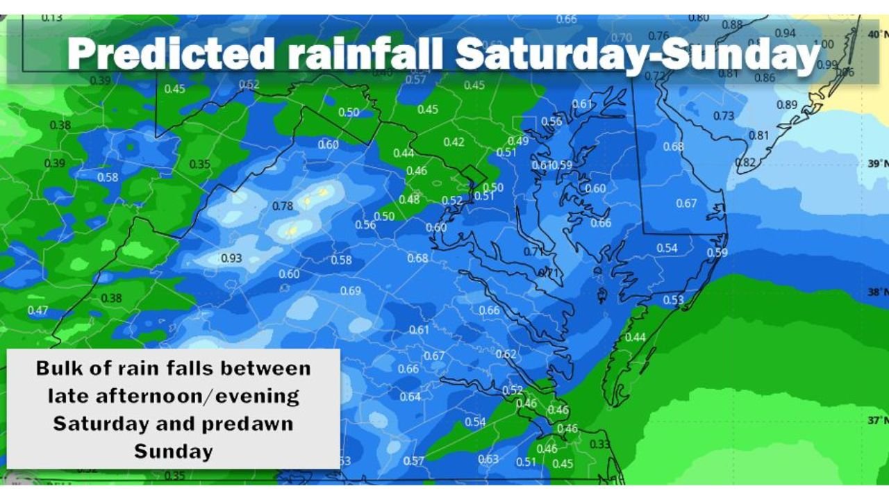
The rainfall map covering Saturday through Sunday shows totals spread fairly evenly across the region with some local variation:
Washington D.C. metro sits in the 0.50 to 0.60 inch range, with some spots picking up slightly more depending on where heavier cells develop Saturday evening.
Maryland shows 0.50 to 0.82 inches across most of the state, with the higher totals pushing toward the Eastern Shore and Chesapeake Bay corridor where values reach 0.81 to 0.89 inches.
Northern Virginia and the Shenandoah Valley are looking at 0.46 to 0.68 inches, with the western mountain counties on the lower end of that range.
Delaware and southeastern Pennsylvania pick up 0.66 to 0.99 inches in spots, with some of the highest totals on the entire map showing up along the Delaware coast and Maryland Eastern Shore where values approach 0.94 to 1.00 inches.
Southern Virginia and the Chesapeake Bay region show 0.44 to 0.67 inches.
The Temperature Story That Changes How Saturday Feels
Temperatures Saturday will sit in the 50s northeast of D.C. and the 60s elsewhere. That is a sharp contrast to the record warm April that D.C. just experienced, where the city hit 80 degrees or higher on 15 separate days. Saturday’s cloudy, cool, drizzly feel will be the first real taste of the below-normal temperature pattern that is locking in across the Mid-Atlantic through the first week of May.
The combination of cloud cover, temperatures in the 50s, and approaching rain makes Saturday feel much more like early March than late April across Maryland and northern Virginia.
What Half an Inch Means for the Drought
The Severe Drought gripping Washington D.C., Virginia, and Maryland requires sustained above-normal rainfall over weeks to recover meaningfully. BWI is running 3.31 inches below normal since March 1. Reagan National is 2.87 inches behind. Saturday’s half inch chips away at that deficit by about 15 to 17 percent at best, which is progress but not recovery.
The more important question is what comes after Saturday. Additional rain chances are signaled for the middle of next week, and the broader early May pattern does lean toward more active conditions across the South and Mid-Atlantic. If those follow-up rain events deliver, the cumulative total over the next 10 days could start making a more meaningful impact on drought conditions. But Saturday alone does not reverse anything.
Sunday Morning Clears Out
The rain exits before dawn Sunday, leaving the region with a mostly dry Sunday ahead. Residents who need to get outdoor tasks done this weekend are better positioned Sunday morning than Saturday afternoon, assuming they can work around the Saturday evening rain arrival.
Make the most of Saturday morning, get inside by 3 PM, and expect a quiet Sunday to follow.
WaldronNews.com will continue tracking rainfall totals across the Mid-Atlantic this weekend and provide updates on drought conditions as the weekly Drought Monitor report is released.