
Davenport, St. Louis and Cedar Rapids Enter the Highly Likely Severe Zone Monday Night as 70 mph Winds and 3 Inch Hail Target Eastern Iowa and Missouri
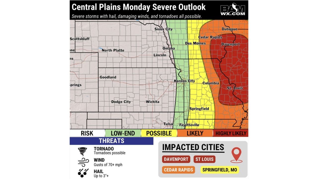
ST. LOUIS, Missouri — Monday night brings the severe weather parade directly into eastern Iowa and Missouri with a Highly Likely severe storm designation now covering Davenport, St. Louis, Cedar Rapids, and Dubuque. The red Highly Likely zone on the Central Plains Monday outlook represents the highest confidence tier on the map, where very large hail measuring 3 inches or larger, destructive wind gusts exceeding 70 mph, and tornadoes are all expected.
Springfield, Missouri sits inside the orange Likely zone just west of the red core. Kansas City and Omaha fall in the yellow Possible zone. Wichita and Tulsa are on the outer Low-End fringe as the threat is centered well to the east of Saturday’s storm activity.
The Four-Zone Breakdown Across the Central Plains
The risk map uses four color-coded tiers that tell a clear geographic story about where Monday night’s worst conditions concentrate.
The red Highly Likely zone covers the eastern fringe of Iowa and the eastern half of Missouri including Davenport, Cedar Rapids, Dubuque, Columbia, and St. Louis. Every threat on the map reaches its highest probability here. A 70 mph wind gust in a populated corridor like St. Louis or Davenport is capable of widespread tree failure, power outages across hundreds of thousands of customers, and structural damage to older buildings and infrastructure.
The orange Likely zone sits immediately west and covers Des Moines, Kansas City, Springfield Missouri, and Fayetteville Arkansas. All three hazards remain probable here though with slightly lower confidence than the red zone.
The yellow Possible zone runs through central Nebraska and Kansas including Omaha, Lincoln, Kansas City on its western edge, Wichita, and Tulsa. Severe storms are possible but the confidence in widespread impact drops significantly in this tier.
The green Low-End zone covers western Nebraska and Kansas where the threat exists but storm coverage will be limited and sporadic.
Why St. Louis and Davenport Draw the Highest Risk
The red Highly Likely designation for St. Louis and Davenport reflects where the atmospheric setup is most favorable for organized, sustained severe weather Monday night. The low pressure system driving Monday’s outbreak is tracking through the Upper Midwest, pulling the warm sector and its deepest instability eastward through Illinois and Missouri during the evening hours.
By the time storms reach the Mississippi River corridor where Davenport and St. Louis sit, they will have had hours to organize, intensify, and develop into well-structured severe weather systems. The 70 mph wind threat in this zone is particularly concerning because organized squall line segments arriving at this speed carry enough kinetic energy to down large trees, snap utility poles, and produce damage indistinguishable from a weak tornado across wide swaths of urban terrain.
Cedar Rapids and Dubuque in eastern Iowa are both inside the red zone, meaning Iowa faces its highest severe weather exposure Monday night in the eastern third of the state rather than the western portions that are in lower threat categories.
The 3 Inch Hail Threat Alongside the Wind
The hail threat listed at 3 inches or larger means the same storm system that produces 70 mph straight-line winds also carries the potential for baseball-sized hailstones. In a city like St. Louis with dense residential neighborhoods and older housing stock, a hail swath from a supercell embedded within the larger storm system can produce millions of dollars in roof and vehicle damage across a single zip code in minutes.
Residents across the red and orange zones should make the same vehicle protection decisions Saturday and Sunday that residents in Oklahoma and Texas made earlier this week. Covered parking before Monday evening is the only reliable protection against 3 inch hail.
The Tornado Threat Is Real Even in the Wind-Dominant Scenario
When a storm system produces primarily squall line wind damage, the tornado threat does not disappear. QLCS systems embedded within larger organized lines regularly spin up brief tornadoes with very short warning times, sometimes less than two minutes between the warning being issued and the tornado passing a given location.
St. Louis, Davenport, and Cedar Rapids need to treat Monday night as a situation where a tornado warning could be issued for any county inside the red zone at any time after dark. Having a shelter plan that works at 10 PM or midnight is just as important as having one that works at 3 PM.
Springfield Missouri Sits in an Interesting Position
Springfield, Missouri inside the orange Likely zone sits just west of the red Highly Likely core. That positioning means Springfield faces a slightly earlier arrival of the storm system while conditions are still transitioning from the supercell phase to the linear phase. The tornado probability for Springfield may actually be higher than for cities further east inside the red zone precisely because it is closer to where discrete supercell activity is most expected during the early evening hours.
The Window to Prepare Closes Monday Evening
The Central Plains severe weather sequence this week ends Monday night with this event. After Monday’s system clears the Mississippi Valley and pushes into the Ohio Valley and Southeast, the pattern begins its transition toward the early May cold pattern that brings the severe weather marathon to a temporary pause.
That makes Monday night the final chapter of one of the most active severe weather weeks across the Central United States this spring. Residents in Davenport, St. Louis, Cedar Rapids, and Springfield Missouri should not be caught unprepared simply because the week’s most dramatic headlines were generated further west earlier in the week.
The worst Monday night conditions arrive for St. Louis and eastern Iowa and they arrive with full force.
WaldronNews.com will continue tracking Monday night’s severe weather across Iowa and Missouri and provide updates as storm timing and intensity become clearer through the day Monday.