
Mid-South Cap Breaking Within Hours as Jackson and Tupelo Corridor Faces All Severe Hazards This Afternoon
JACKSON, Mississippi — The atmospheric cap that has been suppressing storm development across the Mid-South through Monday afternoon is expected to break within the next couple of hours, and when it does, isolated to scattered severe storm development will take place across the region. The more robust storms that develop will be capable of producing all severe hazards — tornadoes, large hail and damaging winds — across a corridor centered over central Arkansas and northern Mississippi.
Why the Cap Is Breaking Now
The 700mb temperature analysis from the HRRR model valid Monday April 27 at 4 PM CDT explains both the suppression and the coming release. The 700mb temperature field — shown in yellow-green shading across the Mid-South — displays values of 7 to 9°C across the Arkansas and Mississippi corridor. These warm mid-level temperatures are the cap: a layer of warm air sitting above the cooler, moister surface air that physically prevents surface-based parcels from rising freely into the atmosphere.
The mechanism breaking the cap through the afternoon is mid-level cooling combined with increasing ascent. As the upper-level trough advances eastward and mid-level temperatures cool even slightly from their current values, the temperature difference between the capped layer and the rising surface parcels narrows. Once that difference closes enough, convection can punch through the cap explosively — releasing the instability that has been building beneath it all afternoon.
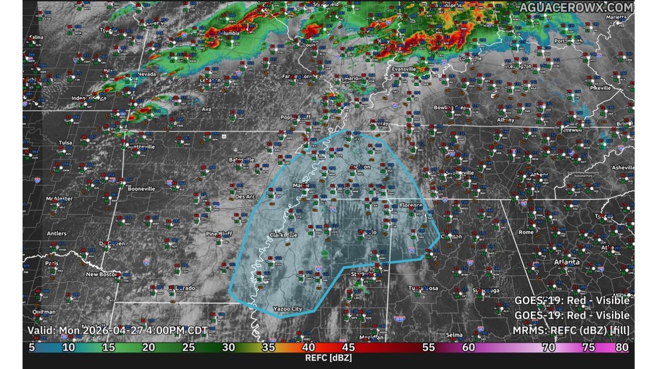
The Suppressed Zone — Clearly Visible on Satellite
The GOES-19 visible satellite image valid Monday April 27 at 4 PM CDT shows the cap’s footprint in stark visual terms. The blue outlined zone covering central and eastern Arkansas through northern Mississippi — from Batesville and Marion through Jackson, Tupelo and Clarksdale — shows a distinctly clear, cloud-free region surrounded by active convection to the north and northwest. This clearing is not a sign of benign weather. It is the visual signature of the cap actively suppressing cloud development over a region with deep surface moisture and building instability beneath it.
The active storm complex visible across Missouri and southern Illinois to the north represents what happens when that cap breaks. The storms already ongoing north of the suppressed zone are the product of the same atmospheric setup — just where the cap has already given way.
What the Cap Break Means for Jackson and Tupelo
The transition from capped and clear to storm development will not be gradual. Cap breaks in high-instability environments tend to be rapid and explosive. Once mid-level temperatures cool enough and ascent increases:
- Isolated to scattered cells will fire across the suppressed zone, initially along the strongest forcing mechanisms — frontal boundaries, outflow boundaries from northern storms and areas of maximum low-level moisture convergence
- The more robust storms that tap into the deep moisture and instability beneath the cap will quickly become capable of all severe hazards
- The environment supports both supercell development — with tornado and large hail potential — and squall line organization — with widespread damaging wind potential — depending on how storm mode evolves after initiation
The corridor from Batesville and Marion, Arkansas southeastward through Jackson, Tupelo and Clarksdale, Mississippi sits directly inside the suppressed zone and faces the highest probability of seeing the first storm development once the cap erodes.
Cities in the Immediate Watch Zone
- Jackson, Mississippi
- Tupelo, Mississippi
- Clarksdale, Mississippi
- Greenville, Mississippi
- Marion, Arkansas
- Batesville, Arkansas
- Forrest City, Arkansas
- Jonesboro, Arkansas
- Florence, Alabama — southeastern edge of the watch zone
What to Do Right Now
- The next 2 to 4 hours are the critical window — the cap break timing determines when storm development begins across this corridor
- Residents across central Arkansas and northern Mississippi should treat this as an imminent severe weather situation and have shelter plans finalized before storms initiate
- Watch for the visible satellite image to change — when cumulus towers begin punching through the capped layer and building rapidly, cap erosion is underway and storm development is minutes away
- The clear zone visible on satellite will not stay clear — its disappearance under rapidly developing convection is the visual signal that the severe weather window has opened
- Keep weather alerts active — the transition from suppressed to active conditions can happen faster than traditional warning lead times allow
WaldronNews.com will continue tracking cap erosion and storm development across the Mid-South and provide immediate updates on tornado warnings and severe storm reports as conditions evolve this afternoon.