
Tornado-Warned Storms Target Southeast Missouri as Arkansas Warm Sector Remains Untouched and Overnight Jet May Initiate New Supercells
POPLAR BLUFF, Missouri — The severe weather focus is sharpening on southeastern Missouri tonight, where tornado-warned storms are ongoing in an environment of favorable shear vectors and potent thermodynamics that could produce a few tornadoes in the deep forest of southeast Missouri. Meanwhile, the Arkansas warm sector — largely untouched by convection through the evening — remains a question mark for overnight storm development as a jet max across northern Texas may extend lift southward and initiate new storms across a relatively fresh atmospheric environment.
What Is Happening in Southeast Missouri Right Now
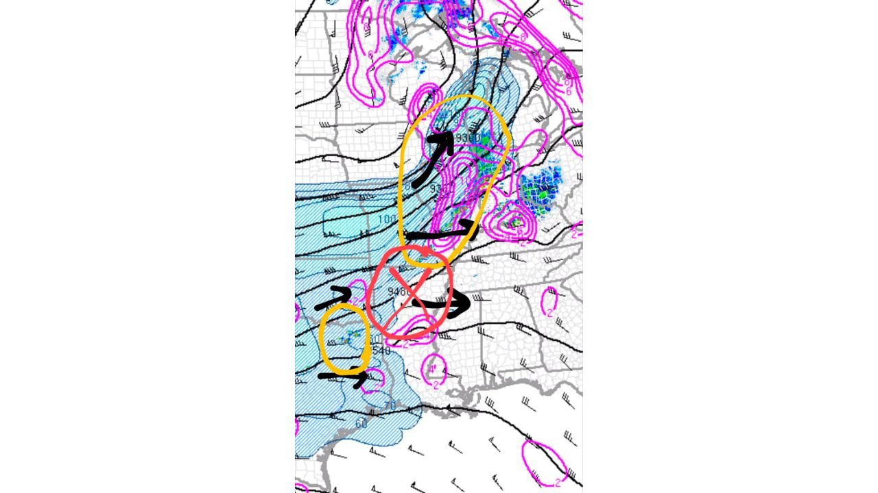
The 300mb analysis shows the upper-level setup clearly. The orange oval marks the region of active storm development across southern Missouri, where lift associated with a jet streak is supporting the tornado-warned cells currently tracked by meteorologists. The 9300 meter height contour and the divergence signature in the magenta contours confirm upper-level support for sustained convection across this corridor.
The favorable shear vectors in southeast Missouri — where winds are veering with height in a configuration that supports rotating updrafts — combined with potent thermodynamics in the warm sector are the ingredients keeping the tornado threat active well into the overnight hours. The deep forest terrain of southeast Missouri presents an additional concern: tornadoes in heavily forested, rural areas are harder to detect visually, harder to survey after the fact and more dangerous for residents in isolated communities with limited shelter access.
The Arkansas Problem — Zero Divergence, No Lift
The complicating factor for Arkansas is the absence of the atmospheric support mechanism that is keeping southeast Missouri active. At 01Z, there is zero divergence or difluence over most of Arkansas — meaning the upper-level dynamics that help sustain thunderstorm updrafts by pulling air upward are essentially absent across the state. Without divergence aloft, updrafts struggle to maintain themselves and storm development stalls or dissipates.
The red oval on the analysis marks this area of concern — supercells and storm activity across northern Texas where a separate jet max is providing subtle but real lift. The yellow oval to the south identifies the broader area where this northern Texas jet may extend its influence southward overnight.
The Overnight Arkansas Scenario
The key question for overnight is whether the northern Texas jet max tracks far enough north and east to extend meaningful lift into Arkansas. If it does:
- The entire Arkansas warm sector — described as relatively untouched and therefore still loaded with instability and moisture compared to areas that have seen storm activity — becomes available for new convective development
- Storm initiation in an untouched warm sector can be explosive because the atmosphere has not been stabilized by earlier convective outflow
- The low-level jet across Arkansas is expected to remain weaker than north — this limits the low-level shear available for tornado production but does not eliminate it entirely, and cap strength will determine whether storms can sustain themselves even with the jet max providing trigger forcing
The scenario forecasters are watching: jet max drift southward overnight initiates isolated supercells across Arkansas into a warm sector that has seen almost no convective activity, producing a brief but potent severe weather window in an area that may have already reduced its alert posture.
Key Factors Separating Tonight’s Outcomes
- Southeast Missouri — active right now with tornado-warned storms, favorable shear and potent thermodynamics, forested terrain making detection and response difficult. This is the highest immediate priority area
- Arkansas — zero lift currently but warm sector intact and untouched. Overnight jet max evolution determines whether this stays quiet or becomes an unexpected late-night severe weather zone
- Cap strength across Arkansas — the weaker low-level jet means the cap may hold even if the jet max provides some lift, which would keep Arkansas suppressed through the overnight hours
What Residents Need to Know Tonight
- Southeast Missouri residents from Poplar Bluff through the Cape Girardeau and Sikeston corridor should treat active tornado warnings seriously — forested terrain means there will be no visual warning of an approaching tornado and electronic alerts are the only defense
- Arkansas residents should not assume the threat has ended for the night — the untouched warm sector scenario with overnight jet max forcing is a real possibility and warrants keeping alerts active through the early morning hours
- Watch for any new tornado watch issuances across Arkansas overnight — a watch issued after midnight would signal that the jet max scenario is materializing and the threat window has reopened
WaldronNews.com will continue tracking tornado-warned storms across southeast Missouri and overnight convective potential across Arkansas and provide updates on warnings and storm reports through the night.