
Kentucky’s Main Severe Weather Line Arrives 10 PM to 3 AM as Cap-Busting Cells Near Paducah Could Turn Tornadic and Louisville Faces Heavy Thunderstorm Now
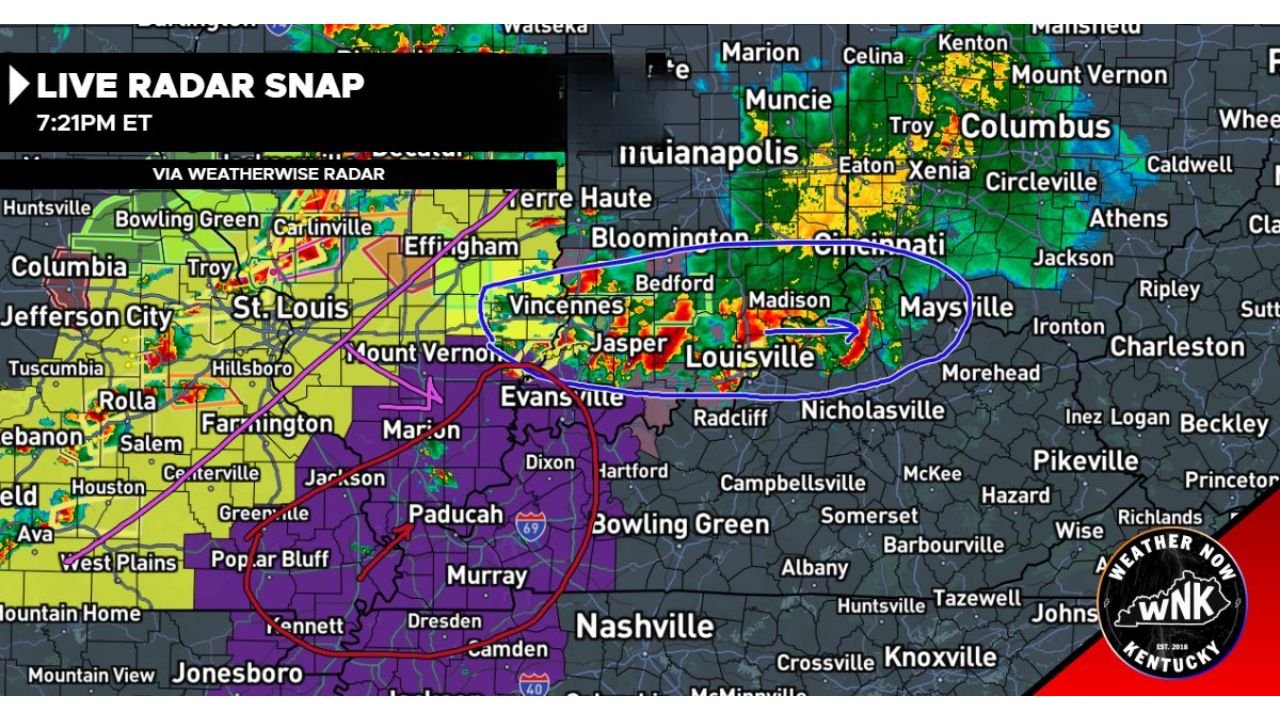
LOUISVILLE, Kentucky — At 7:21 PM Eastern, the Kentucky severe weather situation is active on three separate fronts simultaneously. Cells are beginning to bust through the cap near the Paducah and Murray corridor with the potential to quickly turn tornadic if they mature. The main show — a strengthening squall line — is on track to impact Kentucky from northwest to southeast between 10 PM and 3 AM. And an ongoing MCS is already dumping heavy rainfall on Louisville right now, with Lexington next in line.
The Three Elements on Radar Right Now
Red Circle — Cap-Busting Cells Near Paducah: The most immediately dangerous element on the 7:21 PM radar snap. Discrete cells are punching through the cap across the Paducah, Murray and western Kentucky corridor. Forecasters are watching closely to see if any of these cells mature into organized supercells. If they do, they can quickly turn tornadic — the environment in western Kentucky at this hour has sufficient shear and instability to support rotating storms once cap inhibition is overcome. This is a big if, but it is a real if. Residents across Paducah, Murray, Mayfield and the Jackson Purchase region should be watching radar actively right now.
Pink Line and Arrow — The Main Show, 10 PM to 3 AM: The pink line on the radar marks the position of the primary squall line — described explicitly as the main show for Kentucky tonight. This line is expected to continue intensifying over the next few hours before impacting Kentucky on a northwest to southeast track between 10 PM and 3 AM. The threat with the main line is damaging winds and embedded tornadoes as it pushes through the state. Every community from Bowling Green and Elizabethtown through Lexington and into the eastern Kentucky corridor sits in the path of this line during the overnight window.
Blue Circle — Ongoing MCS, Louisville Now and Lexington Later: The blue oval marks an ongoing MCS — Mesoscale Convective System — already producing heavy rainfall across the Louisville area. The severe risk with this feature is low but not zero, meaning wind and hail are possible but this is primarily a heavy rain and flooding event rather than a tornado producer. Louisville is being poured on right now. Lexington will experience this same system later in the evening before the main squall line arrives.
The Timeline for Kentucky Tonight
- Right now through 9 PM — cap-busting cells in western Kentucky near Paducah and Murray need close monitoring for rapid supercell and tornado development. Louisville under heavy thunderstorm from the MCS
- 9 PM to 10 PM — main squall line approaching from the northwest, beginning to impact the Bowling Green and Elizabethtown corridors
- 10 PM to midnight — main line pushes through central Kentucky including Louisville, Elizabethtown and Campbellsville
- Midnight to 3 AM — main line reaches Lexington and eastern Kentucky, completing the northwest to southeast sweep through the state
- After 3 AM — main event exiting, conditions improving from west to east
Cities and Their Threat Windows
Right now — western Kentucky cap-busting cells:
- Paducah, Kentucky
- Murray, Kentucky
- Mayfield, Kentucky
- Hopkinsville, Kentucky
Right now — MCS heavy rain:
- Louisville, Kentucky — heavy thunderstorm ongoing
10 PM to midnight — main line arrival:
- Bowling Green, Kentucky
- Elizabethtown, Kentucky
- Radcliff, Kentucky
- Campbellsville, Kentucky
- Louisville, Kentucky — second round from main line
Midnight to 3 AM — main line sweeping east:
- Lexington, Kentucky
- Nicholasville, Kentucky
- Richmond, Kentucky
- Somerset, Kentucky
- Morehead, Kentucky
What Kentucky Residents Need to Do Before 10 PM
- Western Kentucky residents near Paducah and Murray — treat the cap-busting cells as an imminent tornado threat right now. If any of these cells mature, warning lead time will be short
- Louisville residents — the current heavy thunderstorm is primarily a flooding concern. Monitor for flash flood warnings and avoid flooded roadways
- All of central and eastern Kentucky — the 10 PM to 3 AM main line window means shelter plans need to be finalized and everyone needs to be inside and weather-alert-ready before 10 PM
- Lexington residents — the MCS arrives first, then the main line follows. Both events require active weather monitoring through the overnight hours
- Keep NOAA weather radio running through the night — the 10 PM to 3 AM window spans normal sleeping hours and electronic alerts are the only warning system available when warnings arrive in the middle of the night
WaldronNews.com will continue tracking Kentucky’s overnight severe weather threat and provide real-time updates on cap-busting cell development, tornado warnings and main line progression through 3 AM.