
Southern Indiana and Illinois Flood Risk Grows as 3 to 5 Inches Already Fell and More Rain Targets Evansville Through Wednesday Morning
EVANSVILLE, Indiana — A serious flooding situation is developing across southern Indiana and Illinois after a corridor of 3 to 5 inches or more of rain fell across the region over the past 24 hours — and the rain is not finished. Additional locally heavy rainfall is expected across southern Indiana from late Tuesday evening through Wednesday morning, piling onto already saturated ground and pushing flood risk to a level that demands immediate attention from residents along and south of the Interstate 70 corridor.
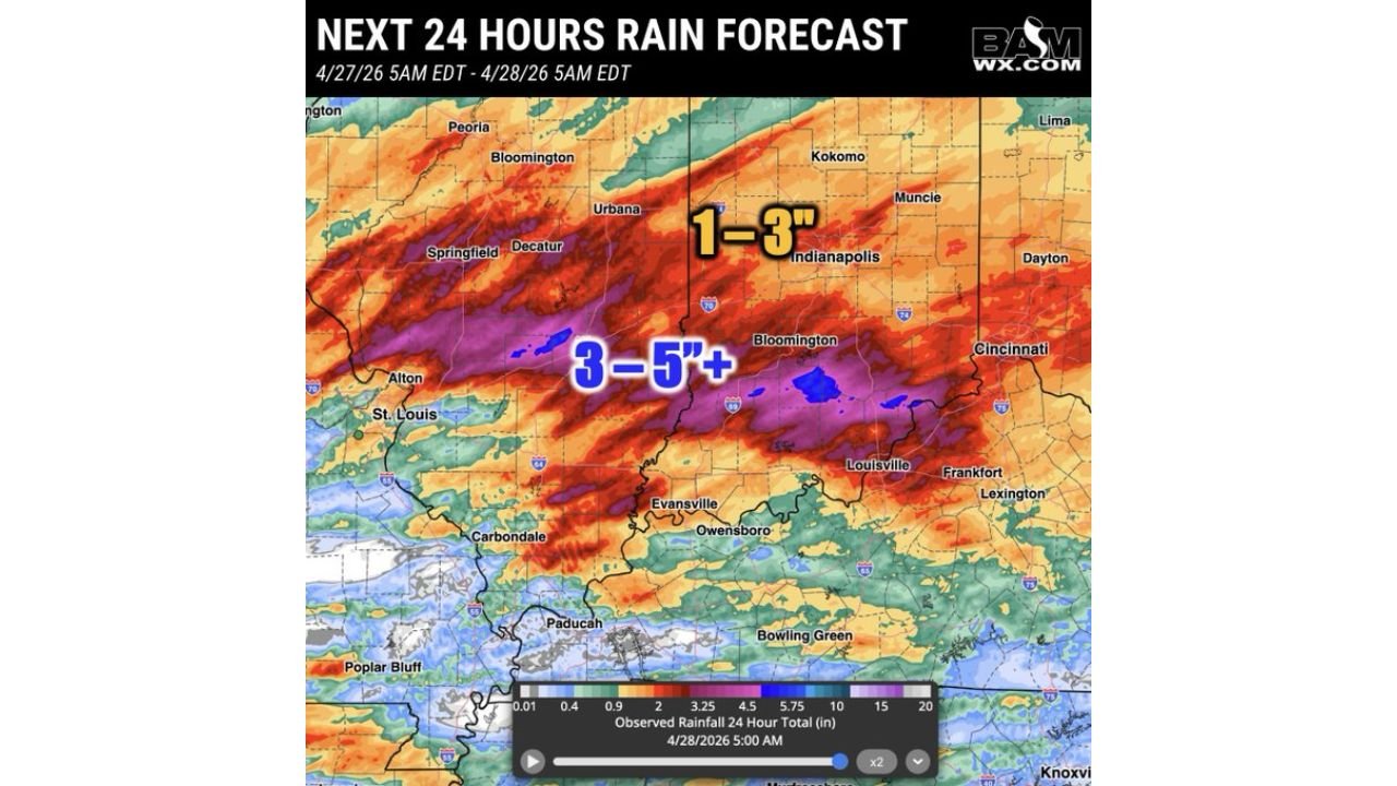
What Already Fell — The 24-Hour Observed Totals
The 24-hour rain forecast valid April 27 at 5 AM through April 28 at 5 AM EDT shows the observed rainfall footprint across the region. The core of the heaviest rainfall — shown in purple shading — cut a concentrated corridor from Alton and St. Louis eastward through Carbondale, Evansville and into Bloomington and Louisville, with totals in the 3 to 5 inch range across the entire width of this band. Isolated blue spots within the purple corridor indicate locations where totals exceeded 5 inches or more in the most intense embedded rainfall pockets.
North of that corridor, Indianapolis and the central Indiana corridor received 1 to 3 inches — significant in its own right but manageable compared to the extreme totals to the south. The gradient between the 1 to 3 inch zone and the 3 to 5 inch zone is sharp, running roughly along the Interstate 70 corridor from Springfield through Indianapolis.
More Rain Coming — Tuesday Night Through Wednesday Morning
The rain event is not over for the hardest-hit areas. The Tuesday night through Wednesday morning rain forecast valid April 28 through April 29 shows an additional rainfall footprint targeting the same southern Indiana corridor that already absorbed the heaviest totals:
- Locally 1 inch or more — the orange dashed oval on the forecast map marks the zone of highest additional rainfall concern, centered over southern Indiana from Evansville eastward through Bloomington and into the Cincinnati corridor. Specific forecast values show 0.95 inches near Bloomington, 0.72 inches near Cincinnati and 0.56 inches near Indianapolis
- Approximately 0.5 inches — across the Ohio Valley corridor from Cincinnati eastward through Dayton, Columbus and into West Virginia
- 0.25 to 0.5 inches — the broader zone covering northern Indiana, Ohio and the Great Lakes fringe, including 0.52 inches near Dayton and 0.29 inches near Cleveland
- Light amounts of 0.05 to 0.13 inches — across the Chicago metro, Milwaukee, Fort Wayne and the northern tier
The problem with the additional 1 inch or more targeting southern Indiana is not the number in isolation — it is the number on top of 3 to 5 inches that already fell on saturated soil. When the ground is already at or near field capacity, additional rainfall has nowhere to go except into streams, rivers and surface runoff. Flash flooding and river flooding become likely at totals well below what would cause flooding on dry soil.
The Severe Weather Boundary and What It Means
The main severe weather risks stay south of the Ohio River tonight, meaning the active thunderstorm and tornado threat shifts away from Indiana and Illinois as Tuesday evening progresses. This is good news for the severe weather component — but it does not eliminate the flooding threat. The additional locally heavy rainfall expected across southern Indiana through Wednesday morning can arrive in non-severe storms that still drop rainfall fast enough to overwhelm drainage systems and raise river levels rapidly.
Cities and Areas at Highest Flood Risk
Already saturated — 3 to 5 inches received:
- Evansville, Indiana
- Bloomington, Indiana
- Carbondale, Illinois
- Alton, Illinois
- Louisville, Kentucky
- Owensboro, Kentucky
Additional 1 inch or more incoming Tuesday night:
- Evansville, Indiana
- Bloomington, Indiana
- Cincinnati, Ohio
- Vincennes, Indiana
- Paducah, Kentucky
What Residents Need to Watch Through Wednesday Morning
- Do not drive through flooded roadways — the combination of 3 to 5 inches already on the ground and an additional inch arriving overnight means water over roads in southern Indiana is not clearing before more rain falls on top of it
- Rivers and streams across southern Indiana and Illinois are running high from the first rainfall event — any additional rainfall will push water levels higher faster than normal because the upstream watershed is already saturated
- Watch for flash flood warnings issued specifically for the Evansville and Bloomington corridors through Wednesday morning — these are the areas where the heaviest new rainfall is targeting ground that is already at capacity
- Basement flooding is a significant risk across the 3 to 5 inch zone — sump pumps that ran hard through Monday night may be overwhelmed by additional Tuesday night rainfall arriving on top of saturated conditions
- The Ohio River corridor from Evansville downstream toward Louisville should be monitored for river flood stage changes through midweek as cumulative runoff from the full storm system arrives
WaldronNews.com will continue tracking flood warnings, river levels and rainfall totals across southern Indiana and Illinois through Wednesday and provide updates as the additional rainfall event moves through the region.