
Florida Eyes Above Normal Rain Through Early June as Hot Dry Caribbean Signal Raises Early Tropical Development Concerns
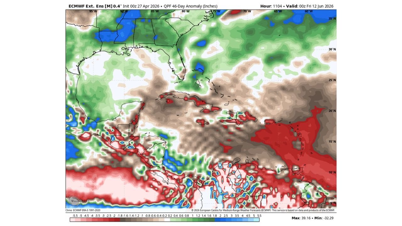
MIAMI, Florida — For the first time in what forecasters describe as a very long while, longer-range models are showing consistent signals for above average precipitation across Florida through early June. The ECMWF extended ensemble, initialized April 27, shows a 46-day QPF anomaly that puts Florida on the wet side of normal through the June 12 valid date — a meaningful shift after an extended period of below-normal rainfall across the state. But the same forecast package carrying good news for Florida’s rain deficit also contains a signal that deserves close attention: a hot and dry anomaly over the Caribbean, Gulf and Bahamas that could warm nearby waters and raise the potential for early tropical development close to home.
The 46-Day Rainfall Anomaly — Florida Gets Wetter
The ECMWF Extended Ensemble 46-day QPF anomaly valid through June 12, 2026 shows the precipitation picture across Florida and the broader Caribbean basin. Florida sits inside a zone of above normal precipitation — shown in green shading — extending from the Gulf Coast northward through the Florida Peninsula and into the Southeast. The anomaly values across Florida suggest rainfall running 0.4 to 1.2 inches above normal through the extended period, a notable departure from the dry conditions that have dominated the state.
This above-normal signal aligns with the approaching rainy season onset expected in early June, and the model suggesting above-average anomalies for this period indicates the rainy season may arrive with more vigor than recent years. For a state where two-thirds of annual rainfall falls between June and September, an above-normal early rainy season start has significant implications for water supply, agriculture and drought recovery.
The contrast with the surrounding region is stark on the same map. The Caribbean, Cuba, the Bahamas and the Gulf of Mexico are covered in brown and deep red shading — indicating a hot and dry anomaly of significant magnitude across these areas through the same 46-day period. Values across the central Caribbean show anomalies reaching 2.5 to 5.5 inches below normal in the driest areas, with portions of the deep tropics showing even more extreme dry departures in red shading.
The Temperature Signal — Warm Waters Near Home
The ECMWF 2-meter temperature anomaly for Days 0-32 valid through May 29, 2026 shows the heat distribution across the region. The Caribbean basin, Gulf of Mexico and Bahamas are running above normal temperatures — shown in yellow and light orange shading — with values generally 1 to 3 degrees Celsius above the 1991-2020 climatological average across the waters surrounding Florida.
This is the signal forecasters are watching carefully for tropical implications. The connection is direct:
- Hot and dry conditions over the Caribbean and Gulf suppress cloud cover and rainfall, allowing more solar radiation to reach and warm the ocean surface
- Above-normal sea surface temperatures provide the fuel — warm water — that tropical systems need to develop and intensify
- Waters that run 1 to 3°C above normal heading into late May and early June are waters that are primed for tropical development earlier in the season than historical averages would suggest
The Bahamas and the waters immediately east and southeast of Florida show some of the most elevated temperature anomalies on the map, placing potential development pathways close to the Florida coast rather than in the deep tropics where early season systems typically originate.
Why Early Tropical Development Near Home Is a Concern
The Atlantic hurricane season officially begins June 1, but tropical systems do not observe the calendar. The combination of factors assembling in the extended forecast — hot, dry air suppressing rainfall over warm Caribbean and Gulf waters while sea surface temperatures run above normal — creates conditions where early season tropical development becomes more probable than climatology alone would suggest.
Early season systems that develop close to Florida and the Gulf Coast are particularly difficult to forecast and respond to because:
- Lead time is compressed — a system developing in the Bahamas or Gulf has far less distance to travel before reaching the coast than a system developing off the African coast
- Warm nearby waters can support rapid intensification even in systems that look modest at formation
- Early June storms arrive before many coastal residents have completed hurricane preparedness routines
The hot and dry Caribbean signal on the 46-day anomaly map is not a hurricane forecast — it is a precursor signal that the oceanic environment heading into early hurricane season is running warmer than normal in areas that matter for near-Florida development.
What to Watch Through May and Into June
- Florida rainfall should trend above normal through early June — residents dealing with drought conditions across the state can expect meaningful improvement but should not expect a single large event to close the deficit
- Sea surface temperature monitoring across the Bahamas, eastern Gulf and Caribbean through May will be the key indicator of whether early tropical development potential is increasing or moderating
- The above-normal temperature anomaly currently in place through May 29 gives warm water conditions approximately 3 to 4 weeks of additional heating time before the official hurricane season begins
- Any tropical disturbance entering the Caribbean or Gulf during late May or early June should be monitored more closely than typical given the warmer-than-normal water temperatures that will be in place
WaldronNews.com will continue tracking Florida’s evolving rainfall pattern and early season tropical development potential through May and June and provide updates as sea surface temperatures and model signals develop.