
Tennessee, Kentucky and Northeast Arkansas Still Face 60 mph Winds and Isolated Tornado Risk Early Tuesday as Chicago and Indianapolis Go All Clear
NASHVILLE, Tennessee — The overnight severe weather threat has split cleanly into two very different stories as Tuesday morning approaches. North of a defined boundary running from the St. Louis corridor through Cincinnati and into the Mid-Atlantic, the severe weather threat has exited the area and conditions are clearing. South of that line — across Tennessee, Kentucky and northeastern Arkansas — forecasters are continuing to monitor for strong and severe storm development capable of producing wind gusts up to 60 mph, large hail and an isolated tornado through the early morning hours.
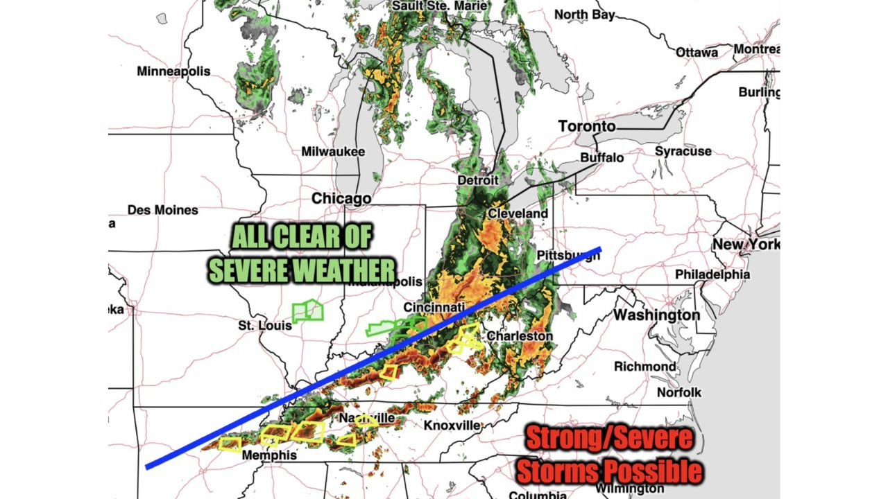
The Blue Line — What It Means and Where It Runs
The dividing line on the Tuesday early morning outlook runs on a southwest-to-northeast axis from approximately the Memphis corridor through Nashville, Charleston, West Virginia and toward Washington D.C. Everything north of this line — including Chicago, Indianapolis, St. Louis, Cincinnati, Cleveland, Pittsburgh and Detroit — is now all clear of severe weather as the storm system exits those areas.
Everything south of the line remains active. The Tennessee Valley, western and central Kentucky and northeastern Arkansas are the zones where meteorologists are watching for additional storm development through the predawn hours. The orange and red radar returns visible along and south of the blue line confirm active convection still ongoing across this corridor, with the heaviest activity concentrated from Memphis eastward through Nashville and into the Knoxville area.
What South of the Line Still Faces
The threats for areas south of the blue line in the early Tuesday morning window:
- Wind gusts up to 60 mph — the primary and most widespread hazard, capable of downing trees and power lines across the active corridor
- Large hail — possible with stronger storm cells still rotating through the southern portion of the risk zone
- Isolated tornado — the lowest probability but still an active concern given the shear environment that persisted through Monday night across Tennessee and Kentucky
The yellow outlined boxes visible on the radar image near Memphis and Nashville mark areas of active watch or warning activity, consistent with the ongoing severe potential south of the blue line.
All Clear North of the Line
The explicit all clear of severe weather designation covers a broad area that saw the worst of Monday’s outbreak through the afternoon and evening:
- Chicago, Illinois — severe weather exiting
- Indianapolis, Indiana — all clear
- St. Louis, Missouri — severe threat ending
- Cincinnati, Ohio — clearing
- Cleveland and Pittsburgh — storm activity moving east and weakening
- Detroit, Michigan — severe threat past
Residents across these cities can stand down from shelter readiness, though some rain and gusty winds may continue as the broader storm system continues its eastward track.
Cities Still Needing Active Monitoring
Tennessee:
- Memphis, Tennessee
- Nashville, Tennessee
- Knoxville, Tennessee
- Jackson, Tennessee
- Clarksville, Tennessee
Kentucky:
- Bowling Green, Kentucky
- Paducah, Kentucky
- Hopkinsville, Kentucky
Northeast Arkansas:
- Jonesboro, Arkansas
- Paragould, Arkansas
- Blytheville, Arkansas
What Residents South of the Line Should Do Right Now
- Keep weather alerts active through the early morning hours — the 60 mph wind and isolated tornado threat is an overnight-into-dawn event, not a daytime situation
- The Memphis to Nashville corridor carries the highest current activity based on radar returns and should treat any severe thunderstorm or tornado warning as an immediate shelter signal
- Do not assume the threat is over because Monday’s main event has passed — the southern corridor is operating on a separate, still-active timeline
- Residents north of the blue line can rest, but anyone from Nashville southward through Memphis and into northeastern Arkansas should remain weather aware until storms fully exit the region after dawn
WaldronNews.com will continue tracking early Tuesday morning storm activity across Tennessee, Kentucky and Arkansas and provide updates on warnings and storm reports as conditions evolve through sunrise.