
Strong Tornadoes Possible in Tennessee and Kentucky Tonight as Intense Low-Level Shear Meets Moderate Instability Near Nashville and Clarksville
NASHVILLE, Tennessee — Forecasters are raising the alert level for Tennessee and into Kentucky tonight, where a combination of intense low-level shear and moderate instability is creating a conditional but real tornado threat within the next 2 to 4 hours. The environment is not clean — some low-level inhibition remains in place and deep-layer shear is weaker than ideal — but if favorable storm interactions occur, a couple of strong tornadoes will be possible. For most of the region, the primary threats will be gusty winds and marginal hail from noisy, disorganized thunderstorms. Remain weather aware.
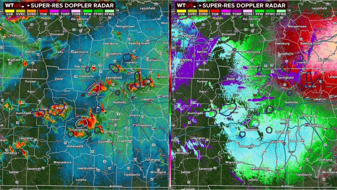
What the Radar Shows Right Now
The Super-Resolution Doppler Radar dual-panel shows the current storm picture across middle Tennessee in both reflectivity and velocity modes. On the reflectivity side, intense red and orange cores are visible across a scattered line of cells from Huntingdon and Camden eastward through Centerville and Spring Hill, with additional activity near Clarksville, Springfield and Portland. The circled features on the radar mark areas of interest where meteorologists are tracking rotation or mesocyclone signatures.
The velocity panel on the right confirms what the reflectivity is hinting at — green and purple couplets near Centerville and along the Clarksville corridor indicate areas of wind rotation within storm cells, the radar signature that precedes tornado development in organized supercells. These couplets are not yet confirming confirmed tornadoes but they represent the exact signatures meteorologists watch closely for rapid intensification.
The Atmospheric Setup — Intense Low-Level Shear With a Catch
The SPC Significant Tornado Parameter analysis valid April 28 at 04Z shows the environment supporting tonight’s threat. The STP — Significant Tornado Parameter, a composite index that combines CAPE, low-level shear, storm-relative helicity and lifting condensation level height — shows red contours pushing into the Tennessee corridor, indicating values elevated enough to support significant tornado development under the right storm interactions.
The hodograph displayed for the Tennessee region confirms the intense low-level shear signal. The hodograph shows a large, curved loop in the low-level layer — the 0 to 1 km portion — indicating strong streamwise vorticity available for supercell updrafts to convert into mesocyclone rotation. This is the ingredient that makes low-level shear so important for tornado production. The low-level shear profile tonight is notably strong even if the deep-layer shear is weaker than a classic outbreak environment.
The catch is weaker deep-layer shear — the total wind change from surface to jet stream level is insufficient to immediately organize storms into classic discrete supercells. This means storms will not organize quickly and will require favorable interactions — boundary collisions, mergers or brief periods of enhanced forcing — before tornado production becomes likely. Without those interactions, the storm mode stays noisy and disorganized, producing mainly gusty winds and marginal hail.
The SBCAPE and SBCIN Picture
The Surface-Based CAPE and SBCIN analysis valid April 28 at 04Z shows the instability environment across the region. SBCAPE — Surface-Based Convective Available Potential Energy — contours push into Tennessee with values in the 100 to 500 J/kg range, moderate but sufficient for organized convection given the intense low-level shear already in place. Moderate instability combined with intense low-level shear is a recognized recipe for low-topped supercells — storms that are not particularly tall or visually impressive but carry well-organized rotation close to the ground.
SBCIN — Surface-Based Convective Inhibition, the negative energy that must be overcome before storms can develop — is shaded across portions of the region, confirming the low-level inhibition forecasters referenced. This inhibition is the main factor keeping the tornado threat conditional rather than certain tonight. Where the inhibition is overcome by frontal forcing or boundary interactions, storm development and intensification can occur rapidly.
Cities to Watch in the Next 2 to 4 Hours
Immediate monitoring zone — Tennessee:
- Nashville, Tennessee
- Clarksville, Tennessee
- Springfield, Tennessee
- Centerville, Tennessee
- Columbia, Tennessee
- Spring Hill, Tennessee
- Portland, Tennessee
- Dickson, Tennessee
Secondary monitoring zone — Kentucky:
- Bowling Green, Kentucky
- Russellville, Kentucky
- Hopkinsville, Kentucky
- Cadiz, Kentucky
- Oak Grove, Kentucky
What Residents Need to Know Right Now
- This is a 2 to 4 hour window — the threat is not a tomorrow morning situation, it is happening now and through the late evening hours
- The difference between a noisy thunderstorm night and a tornado event tonight comes down to storm interactions — if rotating cells along the active line consolidate or encounter a boundary, tornado development can happen with very little additional warning
- Do not wait for a tornado warning to prepare — identify your shelter location now while conditions allow calm preparation
- The velocity couplets visible near Centerville and Clarksville on current radar deserve close watching — these are the cells most likely to produce the first tornado warning of the evening if rotation tightens
- Keep weather alerts active and volume at maximum through midnight — the overnight low-level jet strengthening will maintain or increase shear through the late evening hours
WaldronNews.com will continue tracking tonight’s tornado-capable environment across Tennessee and Kentucky and provide immediate updates on tornado warnings and storm rotation reports as conditions evolve.