
Tornado Outbreak Underway From Central Illinois to Arkansas With EF3-Plus Tornadoes Possible Near St. Louis Starting at 3 PM
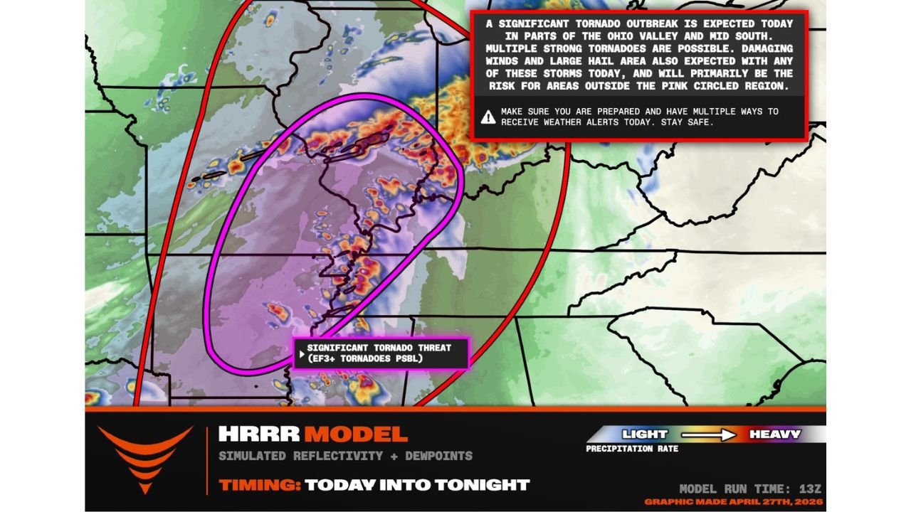
ST. LOUIS, Missouri — A significant tornado outbreak is expected today across the Ohio Valley and Mid-South, with millions of people at risk from multiple rounds of supercells capable of producing strong to violent tornadoes starting as early as 3 to 4 PM. The core of the highest-end threat — where EF3 or stronger tornadoes are possible — runs from central Illinois southward through the St. Louis metro and into Arkansas, outlined in the significant tornado threat zone on the HRRR model simulated reflectivity. This is not a marginal or conditional severe weather event. A significant tornado outbreak is expected today into tonight.
The Outbreak Zone — Who Faces What
The forecast graphic divides the threat into two distinct tiers:
Significant Tornado Threat Zone — EF3+ Tornadoes Possible: The pink circled region on the HRRR output marks the highest-end tornado corridor. This zone covers central Illinois through the St. Louis metro and into northern and central Arkansas. Inside this area, multiple strong tornadoes are expected, with the most intense storms capable of producing EF3 or stronger damage — tornadoes with winds exceeding 136 mph capable of destroying well-built homes, uprooting large trees and creating life-threatening debris fields across wide swaths.
Broader Outbreak Zone — Damaging Winds and Large Hail Primary: Outside the pink circled region but inside the larger red oval, damaging winds and large hail will be the primary threats with any storms that develop. This broader zone covers much of the Ohio Valley and Mid-South and should not be treated as safe — severe thunderstorms with destructive winds and baseball-sized hail can cause significant damage and injuries even without tornado production.
Timing — 3 to 4 PM Is When This Begins
The HRRR model run at 13Z places storm initiation starting as early as 3 to 4 PM local time across the risk corridor, with the outbreak expected to continue and intensify through tonight. Multiple rounds of supercells are anticipated — meaning this is not a single storm line passing through but a repeated sequence of discrete rotating storms developing, intensifying and tracking through the same general corridor over an extended period.
Multiple rounds means:
- Communities hit by the first round of supercells may face additional storms hours later
- The tornado threat does not end when the first storm clears — it resets with each new supercell development
- Residents should maintain shelter readiness through the entire afternoon and evening, not just through the first storm passage
Why EF3-Plus Tornadoes Are Possible Today
The EF3 threshold — 136 mph or greater winds — requires a specific combination of atmospheric ingredients that forecasters are confirming are in place today:
- Very high CAPE — the deep instability fueling explosive updraft development strong enough to support large, violent mesocyclones
- Strong low-level shear and hodograph curvature — the rotational energy that allows supercell updrafts to develop and sustain powerful mesocyclones close to the ground
- Discrete supercell mode — isolated storms with unobstructed inflow that can maintain organized rotation for extended periods before growing upscale
- Multiple rounds — each successive supercell developing into a warm sector that has not been fully stabilized by prior storm activity
The combination of these factors is what separates a standard severe weather day from an outbreak where violent, long-tracked tornadoes become not just possible but expected within the highest-risk corridor.
Cities in the Significant Tornado Threat Zone
- Springfield, Illinois
- Decatur, Illinois
- Champaign, Illinois
- St. Louis, Missouri
- Cape Girardeau, Missouri
- Poplar Bluff, Missouri
- Jonesboro, Arkansas
- Little Rock, Arkansas
- Fayetteville, Arkansas
Cities in the Broader Damaging Wind and Hail Zone
- Chicago, Illinois
- Indianapolis, Indiana
- Louisville, Kentucky
- Nashville, Tennessee
- Memphis, Tennessee
- Evansville, Indiana
- Paducah, Kentucky
This Is a Life-Safety Emergency — Act Now
The language in this forecast is unambiguous. Millions of people are at risk. Multiple strong tornadoes are expected. EF3 or stronger tornadoes are possible inside the highest-threat corridor. These are not hedged, uncertain statements — they reflect a high-confidence outbreak forecast from meteorologists tracking this system in real time.
Every resident inside the outbreak zone needs to act on these three requirements before 3 PM today:
- Be prepared — shelter location identified, everyone in the household knows where to go and how to get there fast
- Have multiple ways to receive weather alerts — NOAA weather radio, phone emergency alerts and a local broadcast source simultaneously. A single alert method is not sufficient for a violent tornado outbreak
- Stay safe — do not be outside, do not be driving and do not be in a mobile home or manufactured structure when tornado warnings are issued for your county
WaldronNews.com will continue providing real-time updates on tornado warnings, storm reports and outbreak progression through tonight. If you are in the risk zone, stay sheltered and stay informed.