
Chicago, Detroit and Washington Face Below Normal Temperatures Through Mid-May as Cold Pattern Suppresses Severe Weather Across the Central and Eastern United States
CHICAGO, Illinois — The first ten days of May are shaping up to be significantly colder than normal across the central and eastern United States, and the cold pattern carries direct consequences beyond just temperature. A below-normal temperature regime pressing down from the Great Lakes through the Ohio Valley and Mid-Atlantic will push the overlapping ingredients for severe weather far to the south, making significant severe weather events across the central and northern tier unlikely through at least the first several days of May. If any severe weather does occur during this period, it will likely be confined to areas very far to the south.
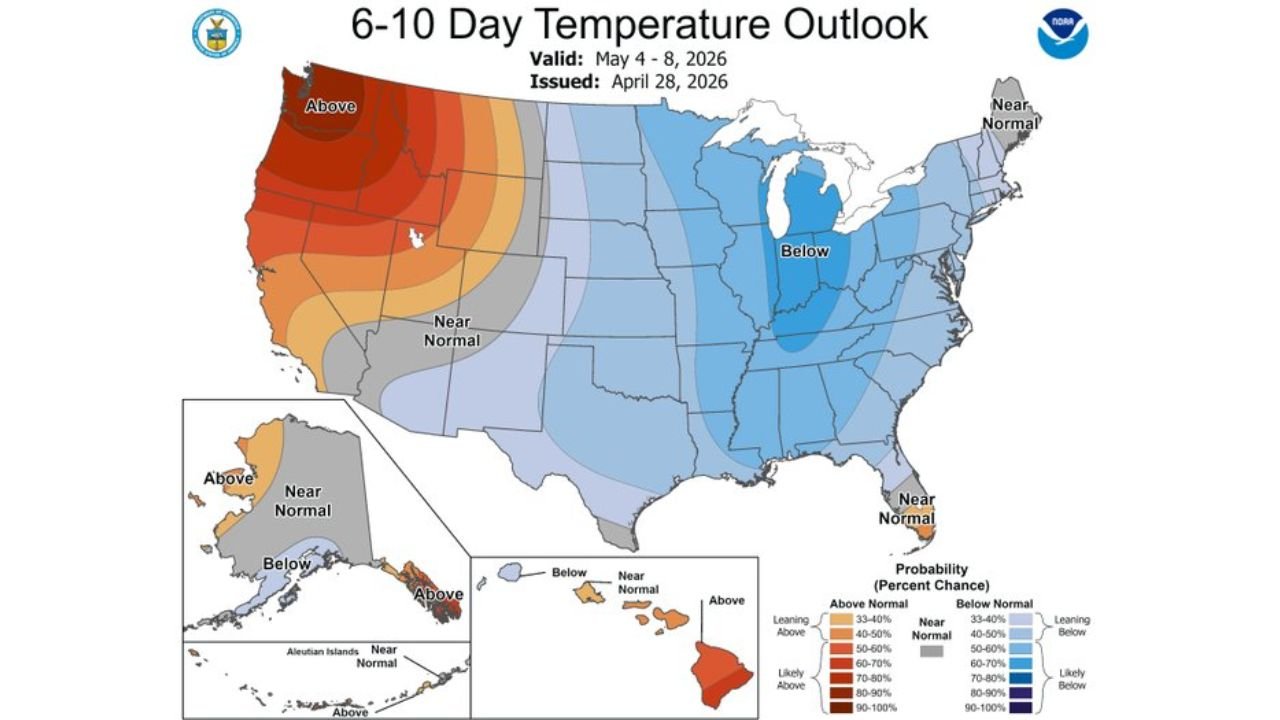
The 6-10 Day Temperature Outlook — May 4 Through May 8
The NOAA 6-10 Day Temperature Outlook valid May 4 through May 8, issued April 28 shows the cold pattern at its most concentrated phase:
- Below normal — 70 to 80% probability — the deep blue shading covers the Great Lakes, Ohio Valley and Mid-Atlantic corridor. Michigan, Ohio, Indiana, Illinois, Kentucky, West Virginia, Virginia, Maryland and Pennsylvania all sit inside the highest-confidence below-normal zone during this period
- Below normal — 50 to 60% probability — the lighter blue shading extends through New England, the Carolinas, Tennessee, Missouri and Iowa, placing the entire eastern half of the country in a below-normal temperature regime
- Near normal — a transition zone across the central Plains from Nebraska through Kansas and Oklahoma and into Texas
- Above normal — 80 to 90% probability — the Pacific Northwest, Oregon, Washington and northern California running well above normal under the western ridge that is the other side of the same atmospheric pattern pushing cold air east
The sharp gradient between the deep red warmth on the West Coast and the deep blue cold across the Great Lakes and East is the visual signature of the pattern configuration — a strong western ridge forcing a deep eastern trough, the same setup that has characterized late April and is now confirmed to persist well into May.
The 8-14 Day Temperature Outlook — May 6 Through May 12
The NOAA 8-14 Day Temperature Outlook valid May 6 through May 12 shows the cold pattern maintaining its grip but with some moderation at the edges:
- Below normal remains the dominant signal across the Great Lakes, Ohio Valley and into the Mid-Atlantic through May 12 — the cold does not break during this window
- The below-normal zone extends southward into the central Plains more aggressively than the 6-10 day outlook, with below-normal probabilities now covering Kansas, Missouri and portions of Oklahoma and northern Texas
- Near normal conditions expand across the southern tier — Texas, Louisiana, Mississippi and Alabama trend toward average rather than the significant below-normal readings seen further north
- Florida shows a small pocket of above-normal temperatures developing by the May 6-12 period, consistent with the warm signal in the extended forecast discussed earlier
- The West Coast warmth persists and expands, with above-normal temperatures now reaching into Idaho, Nevada and Arizona as the western ridge strengthens
What This Pattern Means for Severe Weather
The cold pattern pressing down from Canada has two specific effects on the severe weather setup across the central and eastern United States through early May:
Moisture return is suppressed northward. In a below-normal temperature pattern, the boundary between cold Canadian air and warm Gulf moisture — the warm sector where severe thunderstorms develop — is pushed far to the south. Moisture return will be hard pressed to surge north in a pattern like this, meaning the Gulf moisture that fuels major severe weather outbreaks cannot establish itself across the central Plains, Ohio Valley or Mid-Atlantic during this period.
Severe weather ingredients remain disconnected. Major severe weather requires the overlap of three core ingredients — moisture, instability and wind shear — in the same place at the same time. Cold air suppressing moisture northward prevents that overlap from occurring across the central and northern United States. The result is a pattern favoring rain storms with marginal severe events — isolated strong storms possible but widespread, organized outbreaks unlikely through the first several days of May.
Any severe weather that does develop will be confined to areas very far to the south — the Gulf Coast states where some warmth and moisture can still pool ahead of frontal boundaries even as the cold dominates further north.
Cities Running Below Normal May 4 Through May 12
Highest confidence below-normal zone:
- Chicago, Illinois
- Detroit, Michigan
- Cleveland, Ohio
- Indianapolis, Indiana
- Columbus, Ohio
- Pittsburgh, Pennsylvania
- Washington, D.C.
- Baltimore, Maryland
- Louisville, Kentucky
Extended below-normal zone through May 12:
- Kansas City, Missouri
- St. Louis, Missouri
- Nashville, Tennessee
- Charlotte, North Carolina
- Boston, Massachusetts
- New York, New York
What to Expect Through Mid-May
- Temperatures running 3 to 8 degrees below normal across the Great Lakes and Ohio Valley through May 8, with the coldest anomalies concentrated over Michigan, Ohio and Indiana
- Frost risk for elevated areas of the Appalachians, the Shenandoah Valley and interior New England on the coldest nights within this pattern — vegetation that responded aggressively to April warmth remains exposed
- Severe weather activity suppressed across the central and northern United States — the active outbreak period of late April is giving way to a quiet, cold early May pattern
- The Gulf Coast remains the only viable zone for severe weather development during this period, with any frontal systems tracking across a much more southern storm path than typical for May
- Pattern change signals beyond May 12 remain uncertain — the cold trough’s durability depends on the persistence of the Greenland blocking that has anchored this configuration since late April
WaldronNews.com will continue tracking the early May cold pattern across the central and eastern United States and provide updates on temperature trends, frost risk and any severe weather development that does occur along the southern tier through mid-May.