
North Florida Faces Tornado and Damaging Wind Risk Saturday Based on 2020 and 2018 Storm Analogs
TALLAHASSEE, Florida — North Florida is tracking a credible severe weather threat this Saturday, and two historical analog dates are providing important context for what the atmosphere may produce. The analogs calculated using current model data point to April 20, 2020 and April 8, 2018 as the closest matches to this weekend’s atmospheric setup. Both events produced damaging wind gusts and tornadoes across north Florida, making them fair and meaningful comparisons for what Saturday could deliver.
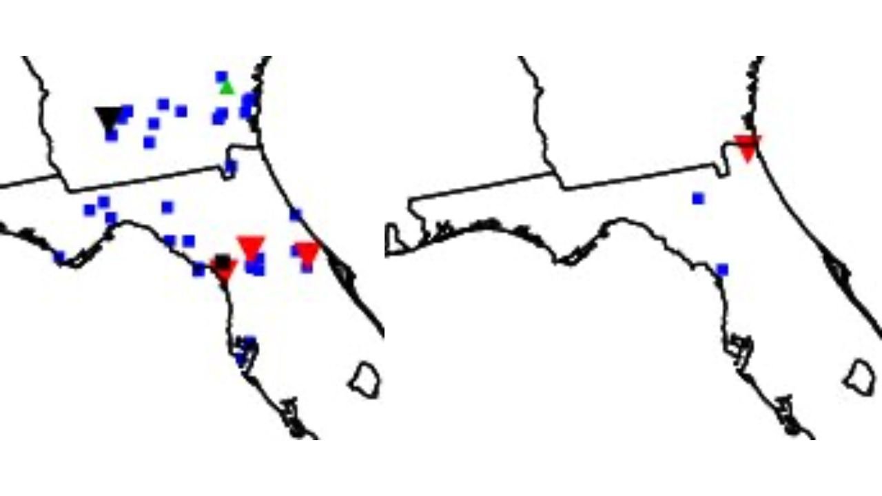
What the 2020 and 2018 Analog Events Actually Produced
The two analog maps show storm reports from each historical event, and the patterns reveal important details about where the greatest risk concentrated.
| Analog Date | Storm Reports Shown | Primary Threat Area |
|---|---|---|
| April 20, 2020 | Multiple tornado reports, scattered severe wind gusts, isolated hail | North Florida and the Panhandle, extending into south Georgia |
| April 8, 2018 | Tornado report near the northeast Florida coast, isolated severe wind | Northeast Florida coast, limited inland coverage |
The April 20, 2020 analog is the more active of the two, with blue severe wind squares spread broadly across north Florida and southern Georgia and red tornado markers indicating confirmed rotating storms. The April 8, 2018 analog shows a more focused and limited event with a single tornado report near the northeast Florida coast and just a couple of wind reports inland. Together they suggest Saturday carries real but not extreme potential, with the worst of any activity most likely concentrated across the northern tier of Florida rather than central or south Florida.
Which Areas of Florida Carry the Most Exposure Saturday
| Region | Risk Level | Based On |
|---|---|---|
| North Florida Panhandle | Elevated | Both analogs show activity in this corridor |
| Northeast Florida coast | Elevated | April 2018 analog shows direct coastal tornado |
| North central Florida | Moderate | April 2020 analog coverage extends here |
| Central Florida and south | Lower | Neither analog shows meaningful activity this far south |
The northeast Florida coastline near Jacksonville and the Panhandle communities are the two areas most directly indicated by the combined analog footprint. Inland north Florida sits between these two zones and carries moderate exposure depending on how Saturday’s storm track sets up.
What Damaging Wind and Tornadoes From These Analogs Means for Residents
| Threat | What the Analogs Show |
|---|---|
| Tornadoes | Confirmed in both analog events, most likely in north Florida and near the coast |
| Damaging wind gusts | Most widespread hazard, scattered broadly across north Florida in the 2020 analog |
| Hail | Green marker visible in 2020 analog, isolated potential |
| South Florida and central Florida | Neither analog produces significant activity this far south |
These analogs are described as fair historical perspective, not a guaranteed repeat. Atmospheric setups never match perfectly. But when two independent historical dates both produce tornadoes and damaging winds across north Florida under similar atmospheric conditions, Saturday deserves serious attention from residents in that corridor.
What North Florida Residents Should Do Before Saturday
- Residents across Tallahassee, Gainesville, Jacksonville, and the Panhandle should have a weather alert method active before Saturday morning. Both analogs fired storms across this corridor.
- Tornado warnings can be issued with very little lead time when rotating storms develop. Knowing your shelter location before warnings are issued is far safer than reacting after one drops for your county.
- The northeast Florida coastline near Jacksonville carries specific analog support from the April 2018 event. Coastal residents should not treat their location as outside the risk area.
- Damaging wind gusts are the most likely widespread impact even if tornadoes remain isolated. Secure outdoor items Friday night across all of north Florida.
- Central and south Florida residents are not in the analog footprint for either event and face a much lower risk Saturday, though isolated storms reaching further south cannot be completely ruled out.
WaldronNews.com will continue tracking Saturday’s north Florida severe weather setup and provide updates as storm timing and tornado watch issuances become clearer heading into the weekend.