
North Carolina and South Carolina Finally Get Much-Needed Rain Wednesday Night Through Thursday as Charlotte, Concord and Rock Hill Face 0.25 to 1.00 Inch Totals
CHARLOTTE, North Carolina — The best rain chance in months is arriving for North Carolina and South Carolina this week, with Wednesday night into Thursday bringing the highest rainfall probability of the next seven days to a region that has been running significant moisture deficits for weeks. Totals will vary widely from 0.25 to over 1.00 inch depending on exact storm placement, and while not everyone will see heavy rain, some locations could finally receive a meaningful dent in their drought conditions.
When the Rain Arrives and How Likely It Is
The seven-day rain probability chart tells a clear story about timing:
| Period | Rain Chance |
|---|---|
| Tuesday Day | Isolated — 0 to 20% |
| Tuesday Night | Widely Scattered — 20 to 40% |
| Wednesday Day | Widely Scattered — 20 to 40% |
| Wednesday Night | “It’s Gonna Rain” — 80 to 100% |
| Thursday Day | Widespread — 60 to 80% |
| Thursday Night | Widely Scattered — 20 to 40% |
| Friday Day/Night | Isolated — 0 to 20% |
| Saturday/Sunday | Scattered building — 40 to 60% |
| Monday Day/Night | Scattered — 40 to 60% |
Wednesday night is the main event. The probability jumps to 80 to 100 percent, the highest category on the chart, before tapering through Thursday daytime.
What the Radar Futurecast Shows
Wednesday 9:00 PM — Moderate to heavy rain bands are pushing across the entire Charlotte metro, with orange and red returns indicating heavier rainfall near Charlotte, Concord, Statesville, Greensboro and Salisbury. The mountains from Asheville through Morganton and Hickory are also seeing active precipitation at this hour.
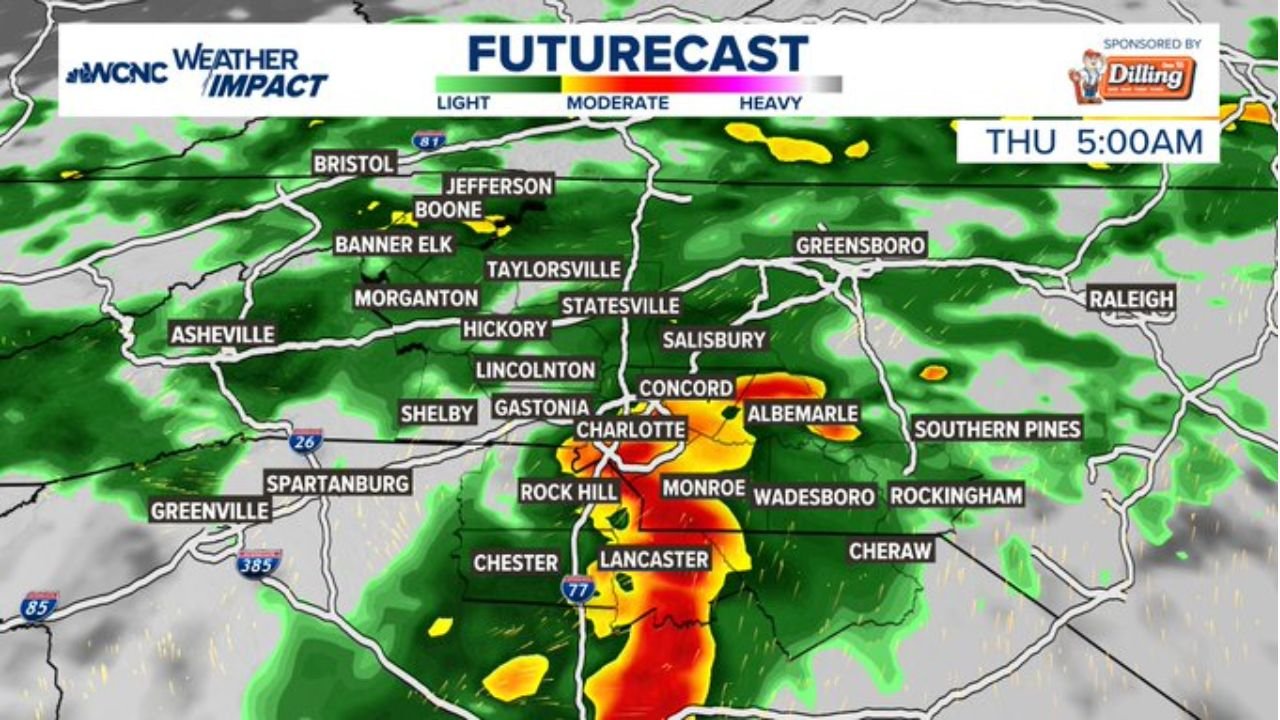
Thursday 5:00 AM — The heaviest rain has shifted south and east by early morning, with intense orange and red returns concentrated near Charlotte, Rock Hill, Monroe, Lancaster and Chester. This is the period where locally heavy rainfall and the strongest storm activity is most likely, occurring entirely during overnight sleeping hours across the region.
Rainfall Totals and What to Expect
Amounts will not be uniform. The forecast calls for 0.25 to over 1.00 inch across the Charlotte metro and Carolinas, with exact totals depending on where the heaviest rain bands set up Wednesday night.
For drought-affected areas, even 0.50 to 1.00 inch in a single event provides temporary relief but does not recover weeks of deficit. The real value of this system is that it represents genuine, soaking rain rather than another dry miss.
A few stronger storms are possible but timing during the morning or after sunset keeps the severe weather risk low for this event. This is primarily a heavy rain and flooding concern rather than a tornado or hail event.
Cities That Should Watch Most Closely
Based on the Thursday 5 AM futurecast showing the heaviest returns:
- Charlotte, Rock Hill, Monroe — heaviest rain most likely overnight into early Thursday
- Lancaster and Chester, South Carolina — intense returns pushing through pre-dawn hours
- Concord and Albemarle — moderate to heavy rain through Wednesday night
- Greensboro and Salisbury — active rain bands Wednesday evening through overnight
WaldronNews.com will continue tracking this much-needed rain event across North Carolina and South Carolina and will provide updated coverage as Wednesday night approaches.