
Arkansas Tornado Outlook Issued for Tuesday May 5 as Little Rock, Conway, Russellville and Batesville Enter 15 to 29 Percent Tornado Probability Zone With EF2 Tornadoes Possible
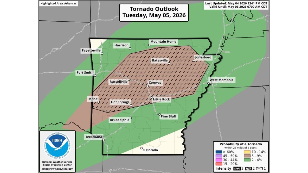
LITTLE ROCK, Arkansas — A formal Tornado Outlook has been issued for Arkansas valid through Wednesday, May 6 at 7:00 AM CDT, placing a large portion of the state inside a 15 to 29 percent tornado probability zone during the late afternoon and evening hours of Tuesday, May 5. A couple of EF2 or stronger tornadoes are considered possible alongside very large hail and damaging winds as supercells develop in a high-shear environment across central and northern Arkansas.
The Tornado Probability Zones
The outlook map breaks Arkansas into clearly defined risk corridors:
15 to 29% Tornado Probability — Hatched Zone (EF2+ possible) The hatching on the map indicates intensity 3, meaning tornadoes of EF2 or greater are specifically anticipated within this zone. Cities inside this highest-risk area:
- Little Rock
- Conway
- Russellville
- Batesville
- Mountain Home
- Hot Springs
- Arkadelphia
- Pine Bluff
10 to 14% Tornado Probability A slightly lower but still meaningful risk zone extends further north and east, covering:
- Harrison
- Jonesboro
- West Memphis
5 to 9% and 2 to 4% Probability Outer zones extend toward Fayetteville, Fort Smith, Texarkana and El Dorado, where tornado chances are lower but not zero.
What the Sounding Data Confirms
A model sounding valid Wednesday May 6 at 00z over 35.63°N, 91.3°W in central Arkansas shows an environment fully capable of producing significant tornadoes:
- Surface CAPE: 378 J/kg, forecast CAPE climbing to 2,098 J/kg as afternoon destabilization occurs
- Storm-Relative Helicity: 2,705 m²/s² — an extraordinary value indicating extreme low-level rotational potential
- STP (Significant Tornado Parameter): 3.5 — well above the threshold associated with significant tornado events
- Supercell Composite: 11.6 — among the highest values possible, confirming an extremely favorable supercell environment
- Critical Angle: 72 degrees — very close to the ideal 90 degrees for tornado-producing supercells
- DCAPE: 774 — strong downdraft potential supporting damaging wind gusts with any storm
- SARS analog: Supercell confirmed, with the hazard type flagged as PDS T08, indicating a particularly dangerous situation tornado environment
What the Evening Radar Simulation Shows
The HRRR simulation valid Tuesday, May 5 at 9:00 PM CDT shows the most intense storm activity concentrated in two areas. Discrete supercell signatures with high Updraft Helicity values appear near De Queen and the southwestern Arkansas corridor, with a separate intense storm cluster pushing through the Batesville and northeastern Arkansas region near Memphis. The EHI (Energy Helicity Index) values of 2 plotted across central Arkansas confirm the environment supports rotating storms capable of tornadoes at this hour.
The Critical Uncertainty
How much afternoon destabilization occurs Tuesday will determine whether this event becomes a significant outbreak or a more isolated tornado threat. If CAPE values rise toward the 2,000+ J/kg forecast level by late afternoon, the SRH of 2,705 and Supercell Composite of 11.6 create the conditions for a very dangerous evening across central Arkansas.
The late afternoon and evening timing means storms will be developing during daylight hours, giving residents the best possible opportunity to receive and act on warnings before dark.
What Arkansas Residents Must Do Today
- Little Rock, Conway, Russellville and Batesville are inside the hatched EF2+ zone. These communities should treat today as a high-priority severe weather preparation day
- Identify your shelter location now, not when a warning is issued. Interior rooms on the lowest floor away from windows
- Ensure weather alert apps and NOAA Weather Radio are active and set to alarm before Tuesday afternoon
- Avoid being outdoors or in vehicles during the late afternoon and evening storm window
- Do not wait for a tornado warning to begin moving to shelter if you can see a threatening storm approaching
WaldronNews.com will continue tracking Tuesday’s Arkansas tornado threat and will provide updated coverage throughout the day as storms develop.