
Northern Corn Belt Faces Much Drier Than Normal Pattern Through 10 Days as Iowa, Minnesota and the Dakotas Drop to 25 to 40 Percent of Normal Rainfall Heading Into Growing Season
DES MOINES, Iowa — The Northern Corn Belt is heading into one of its most critical agricultural windows under a pattern that is forecast to run much drier than normal over the next 10 days, and Pacific Ocean analogs pointing into June suggest the dry trend is unlikely to reverse quickly. Some areas will receive moisture, but top corn producing counties across Iowa, Minnesota, the Dakotas and Nebraska face a genuine soil moisture deficit arriving right at the start of the growing season.
How Far Below Normal Rainfall Will Run This Week
Percent of normal rainfall over the next 7 days by location:
- Bismarck, North Dakota: 25%
- Fargo, North Dakota: 25%
- Minot, North Dakota: 35%
- Sioux Falls area: in the core much-drier-than-normal zone
- Minneapolis, Minnesota: 35%
- Duluth, Minnesota: 40%
- Bemidji, Minnesota: 45%
- Grand Forks, North Dakota: 40%
- International Falls, Minnesota: 35%
- Omaha, Nebraska: 45%
- Lincoln, Nebraska: 45%
- Des Moines, Iowa: 50%
- Cedar Rapids, Iowa: 40%
- Wichita, Kansas: 25%
- Topeka, Kansas: 40%
- Kansas City area: 40%
- Denver, Colorado: 10%
- Cheyenne, Wyoming: 25%
- Casper, Wyoming: 45%
The southern and eastern fringe shows improvement with Chicago at 55 percent, Milwaukee at 55 percent, Indianapolis at 105 percent, Springfield at 85 percent and Toledo approaching 90 percent of normal.
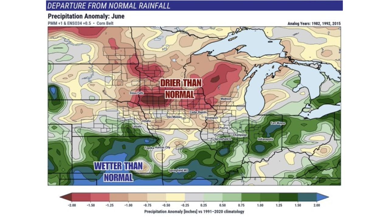
What Pacific Ocean Analogs Say About June
June precipitation anomaly forecasts based on analog years 1982, 1992 and 2015 using PMM plus 1 and ENSO34 plus 0.5 patterns show:
- Sioux Falls, South Dakota through Des Moines, Iowa corridor: drier than normal with anomalies running 0.50 to 2.00 inches below the 1991 to 2020 climatology baseline
- Davenport, Cedar Rapids and Madison zone: drier than normal extending the core dry area eastward
- Southern Plains into Missouri: wetter than normal with positive anomalies providing some contrast to the north
- Great Lakes eastern fringe: near to above normal moisture continuing
The analog years signal that whatever dry pattern establishes itself over the Northern Corn Belt in the next 10 days carries meaningful risk of persistence well into June.
Why This Matters for the Corn Belt Specifically
The counties overlaid on both maps are the top corn producing counties in the United States. Corn planting and early development requires consistent soil moisture from germination through the V6 growth stage. A pattern running at 25 to 45 percent of normal rainfall during this window does not eliminate crop development but it creates compounding stress that becomes increasingly difficult to recover from if June analog guidance verifies drier than normal as well.
The pattern is described as not completely void of moisture, meaning isolated rain events will occur. However, the overall trend strongly favors below normal accumulations across the regions where corn acreage is most concentrated.
What to Watch Over the Next 10 Days
- Iowa and Minnesota top corn counties face the most direct risk as the core much-drier-than-normal zone sits directly over the highest-density production areas
- Bismarck and Fargo at 25 percent of normal represent the driest end of the forecast and will need significant pattern correction to avoid early season stress
- June analog guidance from 1982, 1992 and 2015 all favor continuation of below normal precipitation across the Northern Corn Belt, making a quick recovery less likely
- The southern Plains buffer is real but limited — wetter than normal conditions across Kansas, Missouri and southern Illinois will not compensate for deficits further north
- Monitor soil moisture reports weekly as planting progress and early crop ratings will reflect whether the dry pattern is translating into ground-level stress
WaldronNews.com will continue tracking rainfall patterns and agricultural drought risk across the Northern Corn Belt and will provide updates as the 10-day pattern evolves through the start of the growing season.