
Mississippi and Southwest Mississippi Face Long-Tracked Violent Tornadoes as Models Underperformed Thermodynamics and Kinematics Exceeded Expectations Wednesday
JACKSON, Mississippi — Wednesday’s severe weather event across Mississippi exceeded meteorological expectations in ways that mattered most. Models underperformed significantly on both thermodynamics and kinematics, with both overperforming on the actual day, driving a more intense and localized tornado threat than the setup suggested on paper. Long-tracked, likely intense and possibly violent tornadoes occurred in southwest Mississippi, with additional tornadoes confirmed in southeast Mississippi, both driven by mesoscale interactions that the broader outlook could not fully capture.
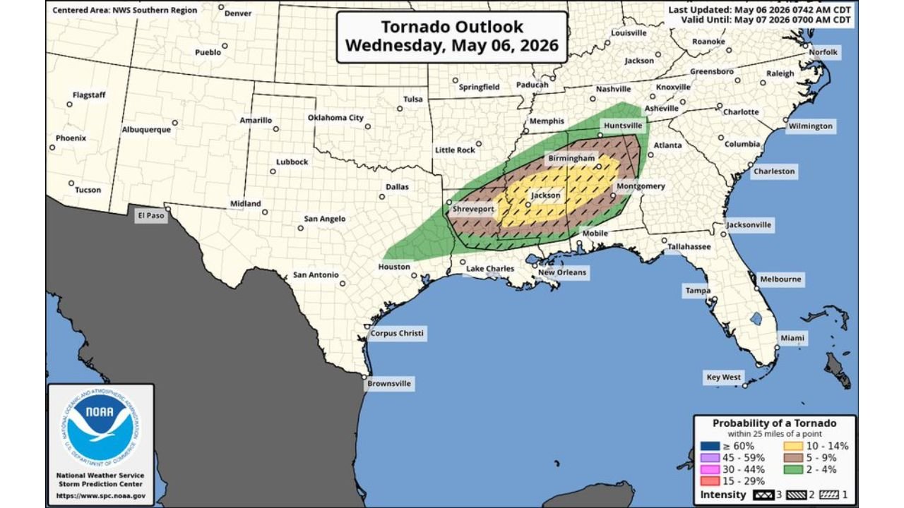
What the Tornado Outlook Showed for May 6, 2026
The tornado probability outlook valid through 7:00 AM CDT May 7, 2026 placed the following probabilities within 25 miles of a point:
- 30 to 44% tornado probability: Core zone covering Jackson, Shreveport and the southwest Mississippi corridor with hatching indicating significant tornado potential
- 15 to 29% probability: Expanding zone reaching Birmingham, Montgomery and the broader Mississippi and Alabama corridor
- 10 to 14% probability: Outer ring covering Huntsville, Memphis and portions of Louisiana toward New Orleans
- 2 to 9% probability: Fringe coverage into east Texas, Arkansas and the Florida panhandle
Intensity hatching across the core zone indicated EF2 or greater tornado potential across the Jackson through Shreveport corridor.
Why Today Exceeded Expectations
- Models flopped hard on thermodynamics — actual instability values ran significantly higher than forecast
- Kinematics also overperformed — wind shear and rotational support exceeded model guidance
- Mesoscale interactions carried both the southwest Mississippi and southeast Mississippi cells to produce significant tornadoes where broader parameters alone would not have supported them
- Historically, setups like today generally do not favor significant tornadoes — but the fine print in mesoscale interactions changed the outcome
- The event remained fairly localized despite exceeding expectations, which limited overall impact but did not reduce intensity where storms did organize
HRRR Sounding Data Valid 7:00 AM CDT May 7, 2026
Forecast sounding for the 30.9 North, 31.2 West, 90.5 West, 89.0 West corridor shows:
- Surface-based CAPE: 3,130 J/kg
- Mixed-layer CAPE: 2,608 J/kg
- Effective-layer SRH: 2,761 m2/s2 — an extraordinarily high value supporting violent tornado potential
- DCAPE: 947
- BRN Shear: 124
- EF Shear (EBWD): 43 knots
- Cordil Downshear: 254 and 88 kt
- STP (fix layer): 3.4
- SHP: 1.6
- Critical Angle: 66 degrees
- Storm Slinky angle: 77 degrees
SARS analog matching returned 86 loose matches with SARS at 67 percent and TGR probability type indicated, consistent with the violent tornado threat that verified during the event.
Radar Signature at 6:00 PM CDT
HRRR simulated reflectivity with 3km Max Updraft Helicity valid 6:00 PM CDT May 6 showed:
- Updraft helicity values of 5 and above concentrated near Columbia and Jackson, Mississippi — the highest values on the display indicating intense rotating updrafts
- EHI values of 2 near Heflin, Alabama on the eastern fringe
- Broad composite reflectivity corridor stretching from Shreveport and Monroe through Jackson, Columbia and Monroeville into the Alabama border
- Additional rotation signatures near Lake Charles and Marksville in Louisiana
What This Event Demonstrates
Mesoscale interactions are not reliably captured by models at the time outlooks are issued. A setup that looks unimpressive on paper can still support long-tracked violent tornadoes when boundary interactions, localized wind shear enhancement and thermodynamic overperformance combine in a small area. Wednesday’s event across southwest and southeast Mississippi is a direct example of why fine-print meteorology matters and why even low-end or marginal outlooks deserve serious attention from residents in the risk zone.
What Remains Active Overnight
- Tornado watch valid until 6:00 AM CDT Thursday for South Alabama and Southern Mississippi
- Flash flood warnings from York and Livingston to Auburn and Opelika with over 4 inches of rain already recorded
- All storms currently below severe limits as of midnight with instability fading
- Flooding remains the primary overnight concern across central Alabama
WaldronNews.com will continue tracking storm reports and overnight hazards across Mississippi and Alabama and will provide updates as damage surveys and warning status change through Thursday morning.