
Oklahoma and North Texas Face Damaging Winds, Large Hail and Isolated Tornadoes This Afternoon as Storms Target Tulsa, El Reno and Wichita Falls Along a Moving Cold Front
OKLAHOMA CITY, Oklahoma — Scattered strong to severe storms are developing across Oklahoma and into north Texas this afternoon and evening along a southward-moving cold front. Damaging winds and large hail are the primary concerns with any storm that reaches severe limits, but a tornado or two cannot be entirely ruled out — particularly if mesoscale interactions develop along the frontal boundary in a way that compensates for the otherwise limited tornado environment.
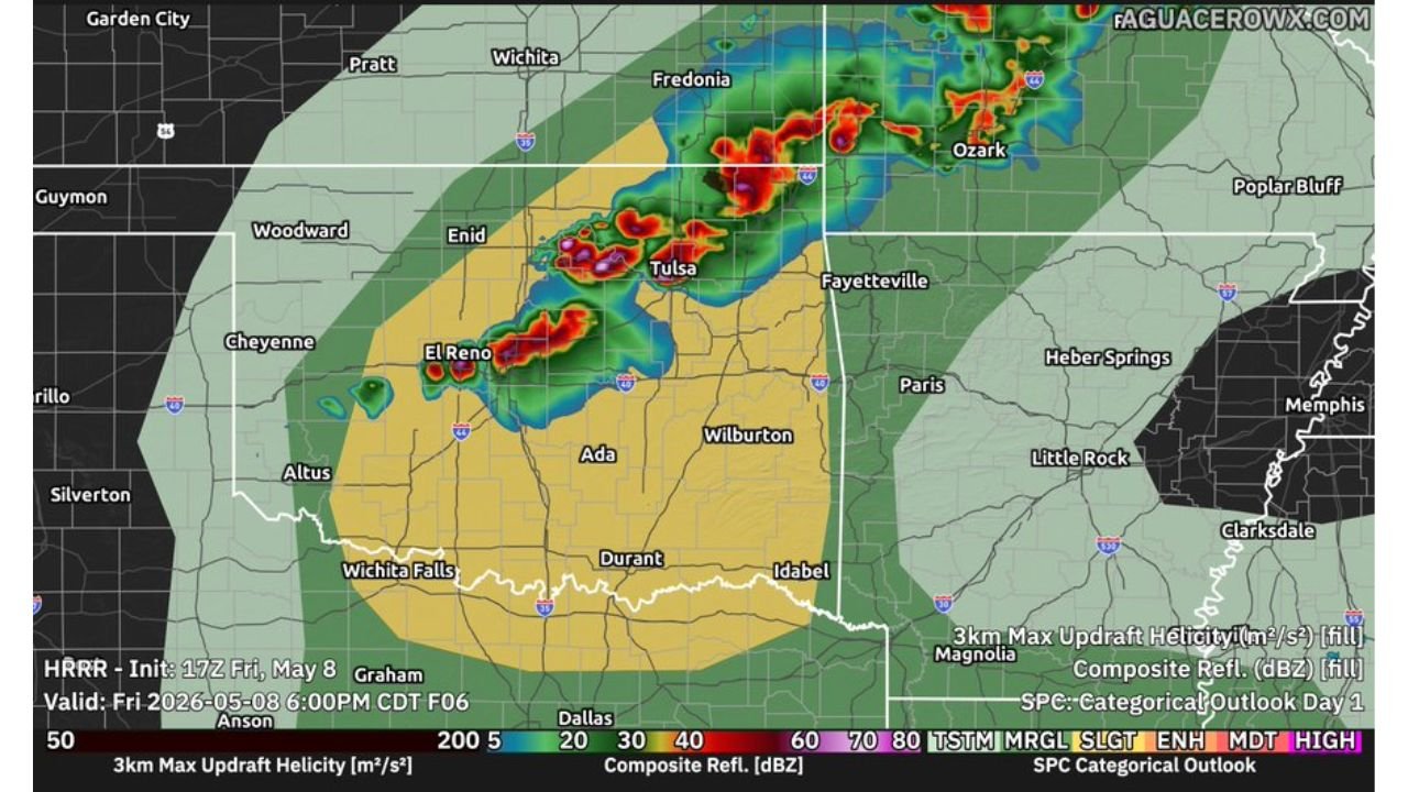
Where the Storms Are Focused
Forecast radar valid 6:00 PM CDT Friday May 8 shows intense storm cores concentrated across:
- El Reno and the Oklahoma City northwest corridor — the most intense cells on the display with the highest updraft helicity values
- Tulsa and the northeast Oklahoma corridor — active cells pushing into the Tulsa metro
- Enid — sitting between the two main storm clusters along the frontal line
- Fredonia and Ozark corridor — storms extending into southeast Kansas and northwest Arkansas
- Wichita Falls, Durant and Idabel — the southern fringe of the threat zone in north Texas and southern Oklahoma
The Slight Risk zone covers central and southern Oklahoma with the Enhanced Risk pushing into the northeast Oklahoma corridor near Tulsa and Fayetteville.
What the Atmosphere Is Showing
Forecast sounding valid 11 PM CDT Friday May 8 near 35.79 North, 95.98 West shows:
- Surface-based CAPE: 1,538 J/kg
- Mixed-layer CAPE: 1,633 J/kg
- Forecast CAPE: 1,628 J/kg
- Effective-layer SRH: 93 m2/s2 — moderate rotational support
- LCL: 1,680 meters — a relatively high cloud base that limits tornado potential
- EF Shear (EBWD): 50 knots — sufficient for supercell organization
- BRN Shear: 53 m2/s2
- Supercell Composite: 2.9
- STP: 0.9 — below the threshold typically associated with significant tornadoes
- SHIP: 1.2 — supports large hail potential
- Critical Angle: 95 degrees — favorable wind alignment for supercell development
- SARS analog: 38% TOR with 94 loose matches — SVR hail type indicated as most probable hazard
Why Tornadoes Are Limited But Not Zero
The sounding data shows high T/Td spread — a large gap between temperature and dewpoint indicating drier air in the lower atmosphere — and weak low-level shear as reflected in the 93 m2/s2 effective SRH. Both factors work against tornado production. However:
- Mesoscale interactions along the cold front can locally enhance low-level shear beyond what the broader sounding captures
- The Critical Angle at 95 degrees is actually favorable for supercell and tornado dynamics
- Wednesday night’s Mississippi event proved that mesoscale interactions can produce significant tornadoes in environments that look marginal on paper
What Oklahoma and North Texas Residents Should Watch
- Large hail is the most likely severe hazard with any storm that becomes organized — SHIP of 1.2 and EF Shear of 50 knots both support hail as the dominant threat
- Damaging wind gusts will accompany the strongest cells along the frontal line from El Reno through Tulsa and into southeast Kansas
- Tornado threat is real but limited — keep alerts active through the evening regardless of the lower STP value
- El Reno and the Oklahoma City northwest suburbs sit under the most intense storm cores as of the 6 PM forecast — residents in this corridor should have shelter identified
- The front pushes south through the evening — communities in Durant, Ardmore and Wichita Falls should monitor conditions into the overnight hours as the threat zone shifts southward
WaldronNews.com will continue tracking severe storm development across Oklahoma and north Texas and will provide updates as storms move through the region this afternoon and evening.