
Kansas, Oklahoma, Missouri, Indiana and Virginia Face Rising Severe Storm and Tornado Chances in the Second Half of May as Pattern Turns Much Warmer After May 15
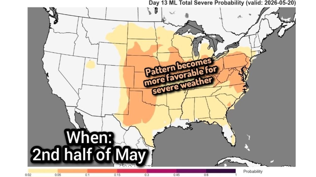
KANSAS CITY, Missouri — The second half of May is shaping up to bring a significant increase in severe weather chances across the central and eastern United States as temperatures turn much warmer after May 15 and stay that way. A machine learning total severe probability forecast valid May 20, 2026 shows the pattern becoming increasingly favorable for thunderstorms and severe weather across a broad corridor from the central Plains through the Ohio Valley and into the Mid-Atlantic, with the highest probabilities concentrated over Kansas, Oklahoma, Missouri, Indiana, Ohio and Virginia.
Where the Severe Weather Probability Is Highest After May 15
Day 13 machine learning total severe probability valid May 20, 2026 by zone:
- Kansas, Oklahoma and Missouri core zone: 30 to 45% probability — the darkest orange bullseye covering the central Plains and lower Missouri Valley
- Indiana, Ohio and Kentucky: 30 to 45% probability — a second high-probability zone in the Ohio Valley
- Virginia, West Virginia and the Mid-Atlantic corridor: 30 to 45% probability — the eastern arm of the threat extending toward the coast
- Nebraska, Iowa and Illinois: 15 to 30% probability — elevated but below the core zones
- North Dakota, South Dakota and Minnesota: 10 to 15% probability — the northern fringe of the active pattern
- Texas and Louisiana: 15 to 30% probability — southern Plains remaining in the active zone
What Changes After May 15
- Much warmer temperatures lock in across the central and eastern United States after May 15 and are expected to stay that way rather than retreating after a brief warm spell
- Sustained warmth increases instability — warmer surface temperatures combined with Gulf moisture surging northward create the thermodynamic fuel needed for severe thunderstorm and tornado development
- The overall thunderstorm and severe weather chance goes up across the entire central and eastern United States as the warmer pattern establishes itself
- Illinois already leads the nation in tornado reports for 2026 — the second half of May pattern adds to an already historically active spring across the region
What to Watch After May 15
- Kansas and Oklahoma residents should treat the second half of May as an elevated severe weather period — the probability map places both states in the highest-risk zone for the May 20 timeframe and the pattern favors multiple active days rather than a single event
- Indiana and Ohio sit in an equally high probability zone — the Ohio Valley does not get the same tornado season attention as the Plains but the data places it at the same risk level for this period
- Virginia and the Mid-Atlantic face an elevated severe threat that extends further east than typical Plains-focused outbreak patterns — residents from Richmond through the Shenandoah Valley should stay weather aware through the second half of May
- The pattern will not shut down after a single outbreak — sustained warmth after May 15 means multiple rounds of severe weather are likely rather than one isolated event
- Exact outbreak days will come into focus within 5 to 7 days of each event — monitor daily forecasts closely from May 13 onward as the active pattern begins to firm up
WaldronNews.com will continue tracking the late May severe weather pattern across Kansas, Oklahoma, Missouri, Indiana and Virginia and will provide updates as specific threat days become clearer through the second half of the month.