
Florida Faces Heavy Downpours Along Interstate 95 in Volusia and Flagler Counties With 20 Lightning Strikes Near Flagler Beach, Daytona Beach and New Smyrna Beach Tuesday May 12 at 6:24 PM
DAYTONA BEACH, Florida — Big downpours are tracking east right now along the Interstate 95 corridor through Volusia and Flagler Counties, Florida as of 6:24 PM Tuesday, May 12, 2026, with 20 total lightning strikes recorded and heavy rainfall causing near-zero visibility on Interstate 95 near Ormond Beach.
This is the last real rain chance for the region until Sunday afternoon this weekend, and despite being a welcome event it will barely dent a drought that requires 20 to 25 inches of rain over the next 3 months to fully break.
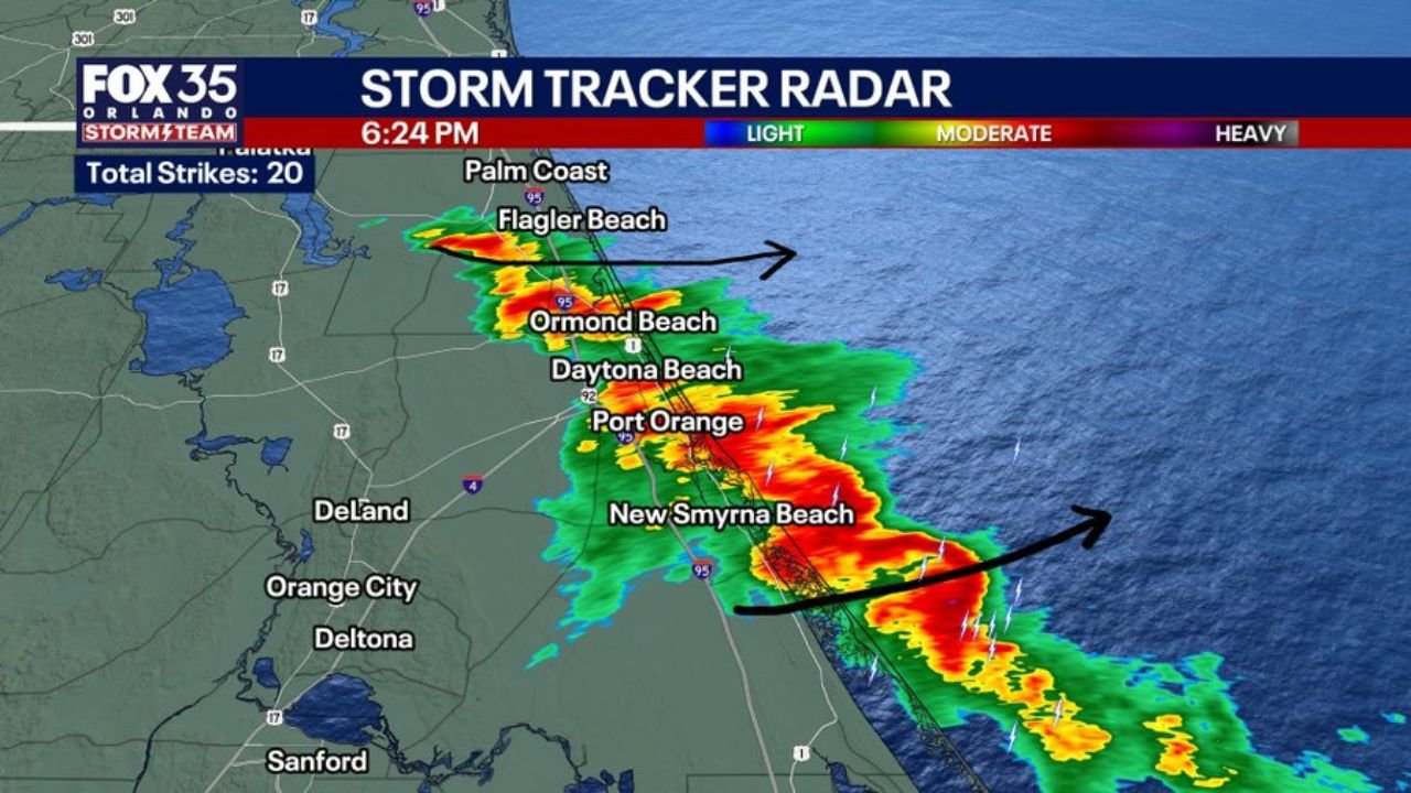
What Radar Shows at 6:24 PM
Storm Tracker Radar at 6:24 PM shows a solid line of heavy downpours stretching along the Interstate 95 corridor from Flagler Beach southward through Ormond Beach, Daytona Beach, Port Orange and New Smyrna Beach, with the storm line tracking east toward the Atlantic Ocean:
The heaviest cells shown in red and orange are concentrated directly over Ormond Beach, Daytona Beach, Port Orange and New Smyrna Beach at 6:24 PM, with 20 total lightning strikes recorded across the active storm corridor. Traffic camera footage from Ormond Beach on Interstate 95 shows near-zero visibility as the heavy downpours move through, with brake lights visible across all lanes as drivers slow dramatically in the blinding rainfall.
Palm Coast and Flagler Beach in Flagler County are on the northern end of the active storm line while DeLand, Orange City and Deltona to the west are staying mostly dry as the downpours track east rather than inland.
Dangerous Driving on Interstate 95 Right Now
The live traffic camera from Ormond Beach on Interstate 95 shows exactly how dangerous conditions are on the highway at this moment. Visibility is near zero. All vehicles have headlights and brake lights activated. Heavy rainfall at this intensity can cause hydroplaning at highway speeds with no warning.
If you are driving on Interstate 95 between Flagler Beach and New Smyrna Beach right now, slow down immediately and increase your following distance significantly. If visibility drops to the point where you cannot see the road ahead safely, pull completely off the highway onto a paved shoulder, turn on your hazard lights and wait for the downpour to pass. Do not stop under an overpass as this creates dangerous situations for other drivers.
The Drought Reality Behind Tonight’s Rain
This downpour is helpful but it is far from drought relief for Volusia and Flagler Counties. The drought affecting central and northeast Florida is so deep that breaking out of it entirely requires 20 to 25 inches of rainfall over the next 3 months. Tonight’s event will contribute something to that total but represents a fraction of what the region needs.
After tonight’s downpours push east, the next real rain chance for Volusia and Flagler Counties is not until Sunday afternoon this weekend. That extended dry gap between Tuesday, May 12 and Sunday will quickly erase any surface moisture benefit from tonight’s storm along the Interstate 95 corridor.
What Comes Next
Dry conditions return to Volusia and Flagler Counties for the remainder of Tuesday night through Saturday as tonight’s storm system tracks east and offshore. Sunday afternoon brings the next rain chance, but residents in Daytona Beach, Ormond Beach, Port Orange, New Smyrna Beach, Flagler Beach and Palm Coast should not expect drought-busting rainfall from that event either given the overall dry pattern dominating the region.
WaldronNews.com will continue tracking heavy downpours and drought conditions across Volusia and Flagler Counties including Daytona Beach, Ormond Beach, Port Orange, New Smyrna Beach and Flagler Beach and will provide updates as rainfall totals and the Sunday rain chance develop through this weekend.