
Florida Freeze Shatters Decades-Old Records as Miami and West Palm Beach Drop to Historic Lows
FLORIDA — An intense Arctic cold surge pushed deep into South Florida early Sunday, shattering long-standing temperature records in both Miami and West Palm Beach and confirming one of the coldest mornings the region has experienced in decades.
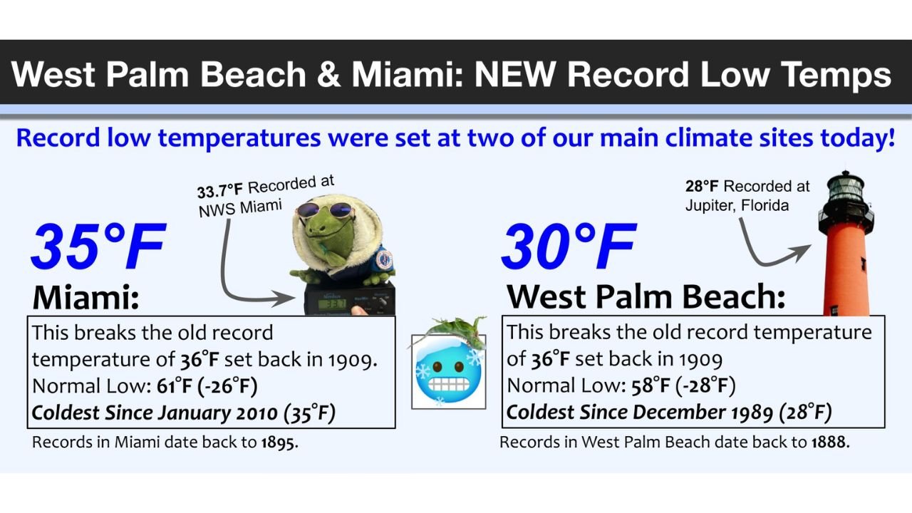
According to National Weather Service data, West Palm Beach plunged to 30°F, breaking a record that had stood since 1909 and marking the coldest temperature observed there since December 1989. At the same time, Miami dropped to 35°F, setting a new record low for the date and registering the coldest reading in the city since January 2010.
Meteorologists described the event as a rare and significant cold outbreak for South Florida, driven by a powerful Arctic air mass that overwhelmed the region overnight.
Historic Record Lows Confirmed Across South Florida
Weather officials confirmed that both cities exceeded previous benchmarks that had endured for more than a century.
- Miami:
- Low temperature: 35°F
- Previous record: 36°F (set in 1909)
- Normal low: 61°F
- Coldest reading since: January 2010
- Records dating back to: 1895
- West Palm Beach:
- Low temperature: 30°F
- Previous record: 36°F (set in 1909)
- Normal low: 58°F
- Coldest reading since: December 1989
- Records dating back to: 1888
The temperature departures were extreme for the region, with readings running more than 25 degrees below normal in some locations.
Freeze Warning Expanded Across Metro South Florida
As confidence increased in the severity of the cold, forecasters expanded the Freeze Warning to include Metro Miami-Dade and Metro Broward Counties, citing a 40–70% probability of temperatures falling below 33°F.
Areas with the highest likelihood of freezing conditions included:
- Redlands
- Parkland
- Davie
- Weston
Inland sections of South Florida were especially vulnerable, where clear skies and light winds allowed temperatures to drop rapidly overnight.
Agricultural and Infrastructure Impacts a Major Concern
Officials warned that the freeze posed a serious threat to agriculture, sensitive plants, pets, and exposed infrastructure, particularly in inland and rural areas.
Forecast guidance indicated:
- Widespread lows in the mid-20s to low-30s
- Hard freeze potential in Glades and Hendry counties
- Elevated risk of damage to tender vegetation and irrigation systems
Residents were urged to rush cold-weather preparations to completion, including protecting plants, bringing pets indoors, and checking heating systems.
Cold Pattern Begins to Ease Early This Week
While the weekend delivered record-breaking cold, forecasters noted that temperatures are expected to gradually moderate as the new workweek begins. However, officials cautioned that additional chilly mornings remain possible, especially in inland areas where cold air can pool overnight.
Even with a warming trend ahead, meteorologists emphasized that this event will be remembered as one of South Florida’s most notable cold snaps in recent history.
What This Means for Residents
- Yes, this was rare — record lows fell in cities that almost never experience freezing temperatures
- Yes, impacts were real — especially for agriculture and outdoor infrastructure
- Yes, conditions will improve — but caution remains warranted over the next few mornings
Have photos, temperature readings, or freeze damage reports from your area?
Share your experience and join the conversation at WaldronNews.com, where we track extreme weather events impacting communities across the country.