
Illinois, Iowa and Wisconsin Brace for Tornadoes and 60% Severe Chance as Storm Targets Chicago This Thursday
CHICAGO, Illinois — A powerful storm system is building for Thursday and Friday, bringing a significant severe weather threat back to Illinois, Iowa, Wisconsin and surrounding states after a brief 5-day quiet stretch.
Warm, humid air pushing upper 70s temperatures will surge back across northern Illinois and Wisconsin by midweek, colliding with a strong low pressure tracking out of the Rockies — setting the stage for what could be a dangerous severe weather outbreak.
Severe Weather Returns to Illinois, Iowa and Wisconsin This Thursday
The threat zone stretching from the central Plains through the Great Lakes is significant. States and cities in the crosshairs include:
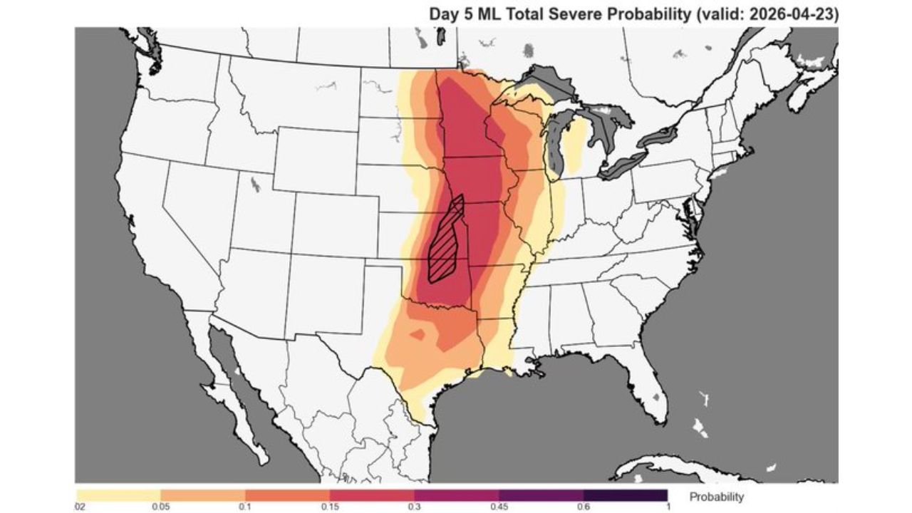
- Illinois: Chicago and surrounding suburbs face the highest risk, with probability reaching 45–60% in the corridor
- Iowa: The state sits at the core of the storm breeding zone, with elevated severe probability across the entire state
- Wisconsin: Northern Illinois moisture surge pushes directly into southern Wisconsin
- Missouri: St. Louis area included in the elevated risk corridor
- Indiana and Michigan: Eastern fringe of the threat zone as the system lifts northeast
Primary Threats
The atmosphere is loading up with several dangerous ingredients heading into Thursday:
- Tornadoes — probability maps highlight a hatched zone over Iowa and Illinois indicating the highest tornado potential, with 45–60% overall severe chance in the core
- Damaging winds — the same low pressure track that fueled 171 high wind reports during last Tuesday’s event is expected to repeat a similar setup
- Large hail — Tuesday’s system produced 258 large hail reports; this Thursday setup carries similar hail-producing potential
- Widespread severe storms — total storm reports from the last comparable event reached 462, including 33 tornadoes
Why This Matters for Chicago and the Midwest
Chicago, Illinois sits right at the edge of where warm Gulf moisture slams into the advancing cold system — and that collision zone is exactly where the most intense storms tend to fire. The city saw its last major severe threat just days ago, and now residents are looking at round two within the same week.
What makes this setup particularly notable is how well the current pattern mirrors what happened last Tuesday. The storm track, moisture return, and low pressure path are nearly identical — and that event produced 33 confirmed tornadoes and over 460 total storm reports across the region. If Thursday’s timing aligns correctly, the Chicago metro, Quad Cities corridor, and the Iowa-Wisconsin border region could all be facing a high-end severe weather day.
The warm front pushing upper 70s back into northern Illinois is key. That temperature and humidity surge is the fuel. Once the low drops in from the Rockies and that warm sector is in place, storms can intensify rapidly — especially during the afternoon and evening hours Thursday into early Friday.
Multi-Day Pattern
Today through Wednesday remains quiet — enjoy the break. The storm window opens Thursday as the low pressure exits the Rockies and moisture surges northward. Thursday afternoon through Thursday night is the primary window to watch. If the system slows slightly, Friday could also see lingering storm activity across northern Illinois and Wisconsin before the pattern finally clears.
Beyond this system, no immediate severe threat is expected into next weekend, but spring continues to deliver active pattern cycles on a near-weekly basis across the Midwest.
What to Watch Next
- Whether the low pressure timing locks in Thursday afternoon or slips to Friday
- Warm front position — how far north the upper 70s moisture pushes into Wisconsin
- Tornado watch or warning issuances Thursday afternoon for Iowa and Illinois
- Wind reports — this pattern supports widespread damaging straight-line winds even outside tornado areas
- Storm reports summary Thursday night as the system moves northeast toward Lake Superior
Chicago and surrounding communities should have their severe weather plans ready before Thursday arrives. Monitor local alerts closely — this system has the ingredients to be significant.
WaldronNews.com will continue tracking this storm system and provide updates as timing and threat details become available.