
Nebraska and South Dakota Supercell Threat Wednesday as 985 mb Low and 1,800 J/kg CAPE Collide Over the High Plains
RAPID CITY, South Dakota — A sneaky but dangerous severe weather setup is taking shape for Wednesday across northwestern Nebraska and the Black Hills of South Dakota, as a sharp 985 mb low pressure system drops into the region while surface-based CAPE values surge past 1,800 J/kg — enough instability to fire supercell thunderstorms capable of producing tornadoes, large hail, and damaging winds.
This is shaping up as a classic “day before the day” scenario — a setup that often catches residents off guard precisely because attention tends to focus on the bigger outbreak expected Thursday and Friday further east.
States and Areas in the Wednesday Supercell Zone
The threat is focused but potent across the northern High Plains:
- South Dakota: Black Hills region and surrounding western South Dakota face the highest supercell potential as the low sharpens overhead
- Nebraska: Northwestern Nebraska in the primary firing zone where late moisture arrival meets favorable wind fields
- Wyoming: Eastern Wyoming on the western fringe as the low tracks eastward
- Kansas: Southern portions may see storm activity Wednesday night as the system begins pushing southeast
Primary Threats
The ingredients for dangerous storms are aligning Wednesday evening:
- Supercell thunderstorms — sharpening low pressure at 985 mb combined with strong mid-level wind fields at 700mb creates the rotation potential for organized supercells
- CAPE values 1,600–1,800+ J/kg — surface-based instability values across northwestern Nebraska and South Dakota are high enough to fuel explosive storm development once moisture arrives
- Tornadoes — favorable wind shear and a tightening low pressure gradient create the conditions supercells need to produce tornadoes
- Large hail and damaging winds — even storms that do not produce tornadoes will carry significant hail and wind threats given the available instability
Why This Matters for the Black Hills and Nebraska Panhandle
Rapid City, South Dakota and communities across the Black Hills sit directly in the zone where this low pressure is expected to sharpen Wednesday evening. The Black Hills terrain can both enhance and complicate storm development — storms firing on the eastern slopes can quickly organize as they move onto the open Plains, where there is nothing to slow their rotation.
What makes this setup particularly tricky is the last-minute moisture arrival. Moisture is not streaming in early — it arrives late, which compresses the severe weather window but also means storms that do fire will have a rapidly destabilizing atmosphere to work with. That combination of late moisture, sharp low, and strong wind fields is exactly the pattern that produces fast-developing supercells that give little warning time.
The 985 mb low shown tracking across the central Plains by Wednesday evening is a strongly anomalous pressure reading for this time of year — the deep blue shading on the pressure anomaly map indicates this system is significantly stronger than climatological norms. That extra strength in the low is what sharpens the wind fields and creates the rotation environment supercells need.
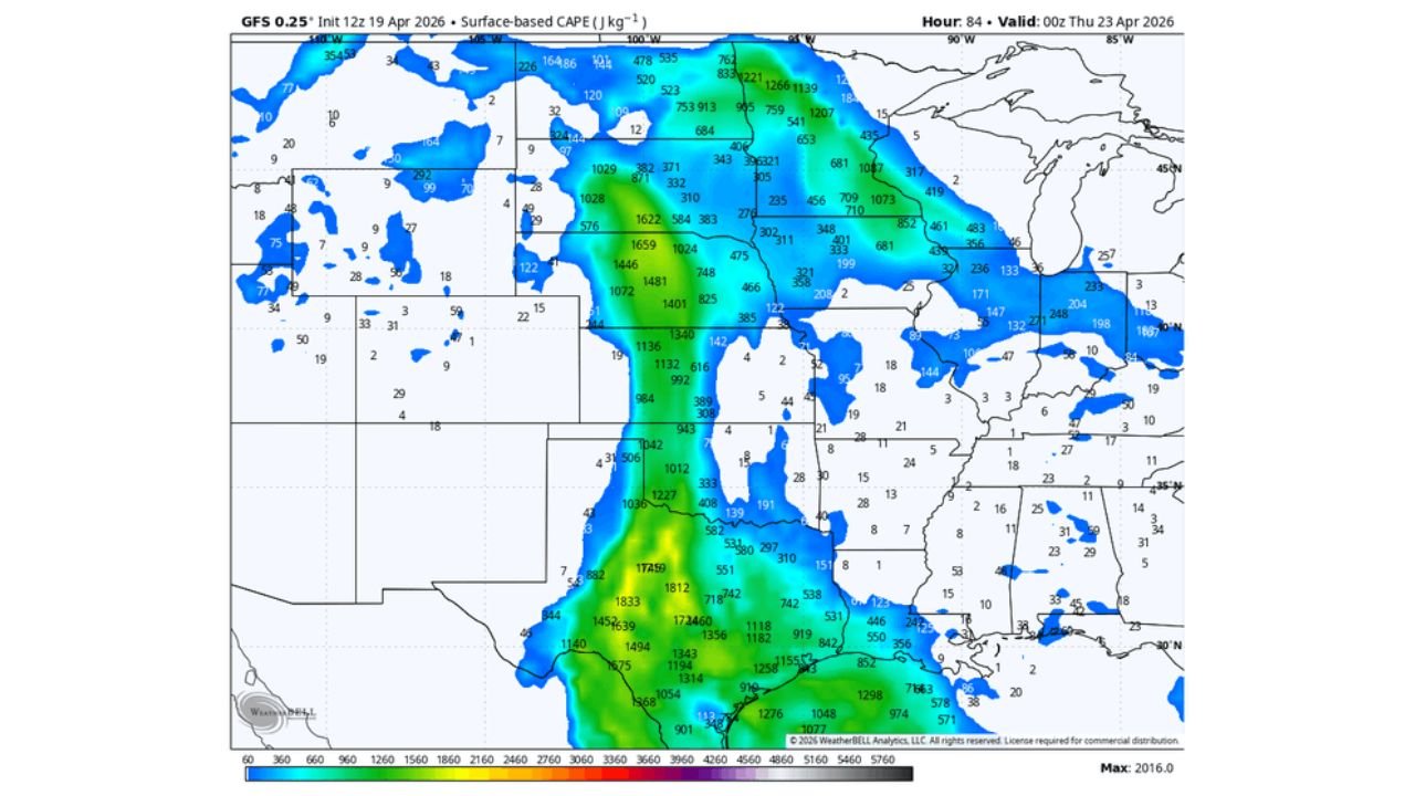
The CAPE map tells the rest of the story: values of 1,600 to 1,800 J/kg are focused directly over Nebraska and South Dakota by Wednesday evening, with the axis of highest instability running right through the target area. This is more than enough energy to support dangerous storms.
Multi-Day Pattern
Wednesday is the opening act. The main severe weather event for Illinois, Iowa, and Wisconsin arrives Thursday and Friday as this same system accelerates northeast. Wednesday’s supercell threat in Nebraska and South Dakota is the precursor — the low deepens, tracks east, and pulls Gulf moisture north ahead of it, setting up the larger outbreak for the Midwest later in the week.
Residents in South Dakota and Nebraska should not wait for Thursday’s headlines to prepare — Wednesday evening is a legitimate severe weather threat in its own right.
What to Watch Next
- Moisture arrival timing Wednesday afternoon across northwestern Nebraska — earlier moisture means earlier storm initiation
- Tornado watch issuances for the Black Hills and Nebraska Panhandle Wednesday evening
- Low pressure deepening — if the 985 mb reading tightens further, severe potential increases
- Storm reports Wednesday night as any supercells track southeast out of the Black Hills
- Thursday setup update as the low accelerates toward Iowa and Illinois
Residents across the Black Hills of South Dakota and northwestern Nebraska should have their severe weather plans in place before Wednesday afternoon. This storm is fast-moving and the window will be brief — but the ingredients are there for a dangerous evening.
WaldronNews.com will continue tracking this system and provide updates as Wednesday’s severe weather timing and Thursday’s outbreak potential become clearer.