
North Carolina and Virginia Weekend Snow Threat Grows as Forecast Confidence Increases for Saturday Impacts
NORTH CAROLINA & VIRGINIA — Confidence is increasing that a winter weather system will bring snow and disruptive travel conditions to parts of North Carolina and Virginia this weekend, particularly from Saturday into Saturday night, according to the latest meteorological guidance. While exact snowfall totals are still uncertain, multiple forecast signals now point toward a higher likelihood of impactful winter weather across the central and eastern portions of the Carolinas and into Virginia.
Meteorologists emphasize that this is the stage of forecasting where storm confidence improves, but details such as exact snow bands, timing, and severity can still shift.
Why Confidence Is Increasing Now
As the system moves into the 1–3 day forecast window, models are beginning to converge on a clearer storm track. This time frame allows meteorologists to better assess:
- Storm development and strength
- Cold air availability
- Moisture supply feeding the system
- Potential rain-snow line placement
At this stage, forecasters can reasonably expect winter weather to occur somewhere in the region, even if final impacts are not yet locked in.
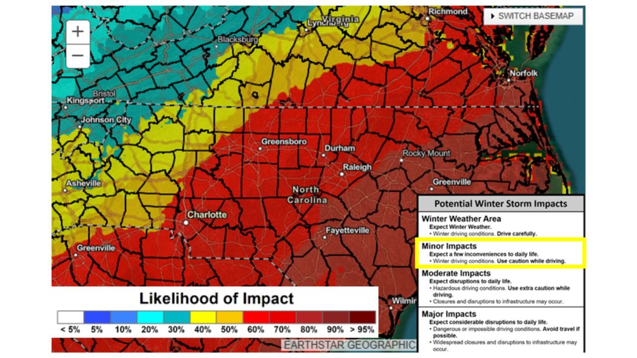
Areas Most Likely to See Winter Weather Impacts
Based on the likelihood-of-impact data:
- Central and eastern North Carolina show the highest probability of moderate to locally significant winter impacts, particularly Saturday and Saturday night.
- Southern and central Virginia are also included in a corridor where snow or wintry precipitation could affect travel.
- Western North Carolina and eastern Tennessee appear more likely to see lighter impacts, though slippery roads remain possible.
- Far eastern coastal areas may see impacts depend heavily on the storm’s exact track and temperature profiles.
These impact zones reflect the chance of disruption, not guaranteed snowfall totals.
What “Minor to Moderate Impacts” Mean
Forecast impact levels are focused on real-world effects, not just accumulation numbers.
- Minor impacts: Slippery roads, reduced visibility, slower travel, and scattered delays.
- Moderate impacts: Hazardous driving conditions, potential road closures, and disruptions to daily routines.
- Major impacts (lower confidence at this time): Widespread travel disruptions and prolonged hazardous conditions.
The current guidance suggests minor to moderate impacts are most likely, with the possibility of higher impacts if the storm strengthens or shifts.
Why Snow Forecasts Change Days in Advance
Meteorologists stress that snowfall forecasting several days out is inherently uncertain due to:
- Storm track variations of 50–150 miles
- Timing differences of 6–12 hours
- Temperature differences that affect rain versus snow outcomes
This explains why early model runs can appear dramatic before settling into more realistic outcomes closer to the event.
Timing: When Impacts Are Most Likely
- Saturday daytime: Wintry precipitation may begin developing.
- Saturday night: Highest risk period for snow accumulation and hazardous travel.
- Sunday: Lingering impacts possible, especially in areas that receive accumulating snow.
Residents with weekend travel plans should pay close attention to updated forecasts.
Bottom Line
Confidence is growing that parts of North Carolina and Virginia will experience winter weather impacts this weekend, especially Saturday into Saturday night. While this does not currently appear to be a historic storm, conditions could still become hazardous, particularly for drivers.
Small shifts in the storm’s track or temperature profiles could significantly change local outcomes, making forecast updates critical over the next 24–48 hours.
Stay weather-aware and continue following Waldronnews for updated forecasts, impact breakdowns, and timing details as this weekend system comes into sharper focus.