
Winter May Try One Last Comeback Across Great Lakes and New England as Mid-March Pattern Shift Brings Colder Air to Northern U.S.
UNITED STATES — Meteorologists are watching signs of a major atmospheric shift developing in mid-March, raising the possibility that winter could make one last appearance across parts of the northern United States, particularly the Great Lakes, north-central states, and interior New England.
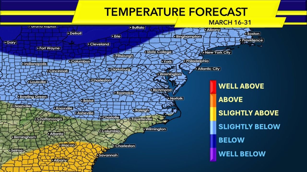
While warmer conditions are expected to dominate much of the southern United States, long-range forecasting signals suggest cooler-than-average temperatures could return to parts of the northern tier later this month.
Polar Vortex Disruption Could Influence North American Weather
Weather analysts point to an imminent Sudden Stratospheric Warming Event (SSWE) — a disruption in the polar vortex high above the atmosphere — as the potential trigger behind the upcoming pattern shift.
When these events occur, they can push larger portions of the polar vortex southward into North America, allowing colder air to spill into the United States weeks later.
If that happens, regions most likely to feel the impact include:
- Upper Midwest
- Great Lakes states
- Interior New England
- Parts of the north-central United States
These areas could see cooler temperatures and a few late-season snow opportunities if the colder pattern becomes established.
Mid-Atlantic Likely to See Up-and-Down Temperature Pattern
Despite the potential northern cold shift, forecasters say the Mid-Atlantic region may experience a more variable pattern, with alternating warm and cool periods rather than a sustained cold outbreak.
Seasonal averages begin rising quickly by mid-March, meaning significant snow accumulation becomes increasingly difficult in cities such as:
- Washington, D.C.
- Baltimore
- Philadelphia
- Richmond
Meteorologists note that by March 15, average daytime highs in many Mid-Atlantic cities reach the mid-50s, requiring unusually strong cold air for snow to accumulate.
Because of this, widespread late-season snow across the Mid-Atlantic appears unlikely outside higher elevations.
Southeast Expected to Stay Warmer Than Average
Long-range temperature outlooks for March 16 through March 31 show above-average warmth dominating the southeastern United States, including areas such as:
- Georgia
- South Carolina
- Southern Alabama
- Northern Florida
This pattern suggests winter is unlikely to return to areas south of Interstate 80, except in mountainous regions.
The warmth across the Southeast could also help limit how far south any Arctic air is able to push.
New England May Still See Late-Season Snow Chances
While the Mid-Atlantic may struggle to see accumulating snow, interior New England could still have a window for one final snowstorm later in March or even early April.
Climatology favors northern New England locations such as Vermont, New Hampshire, and Maine, where colder air lingers longer into the spring season.
In addition, forecast guidance suggests above-average precipitation could occur during this period, increasing the chances that at least one system could produce late-season snowfall in northern areas.
March Pattern Could End Winter for Many Areas
Overall, meteorologists believe the upcoming atmospheric pattern could bring brief cold shots across the northern United States, but it may also mark the final chapter of the 2025-2026 winter season for much of the country.
With spring temperatures climbing rapidly by mid-March, the window for widespread winter weather is quickly narrowing across the eastern United States.
Stay with WaldronNews.com for continuing updates on long-range forecasts, winter pattern shifts, and late-season snow chances across the United States.