
Florida Wildfires to Dominate Headlines for Weeks as No Meaningful Rain Expected Through Mid-May and Temperatures Run Above Normal
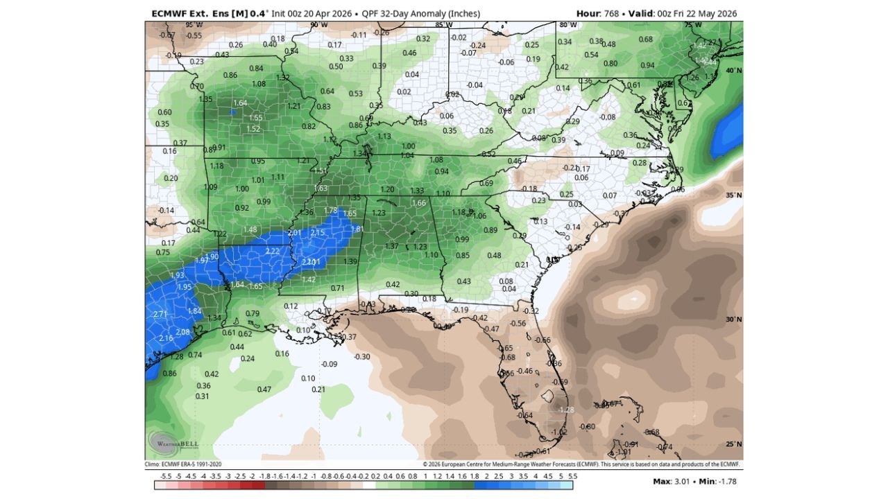
ORLANDO, Florida — There is no relief in sight for Florida’s wildfire crisis. A 32-day rainfall forecast through mid-May 2026 shows Florida running 0.5 to 1.28 inches below normal precipitation while temperatures across central and north Florida run warmer than average — a combination that will keep wildfire danger at critical levels for weeks to come.
Forecasters are being direct: other than random small shower chances, there is no notable rain expected across Florida any time soon. For some areas, meaningful rainfall could be weeks away.
Florida Communities Facing Prolonged Wildfire Danger
The rainfall deficit and above-normal heat affect the entire state:
- Central Florida: Orlando and surrounding communities — rainfall running below normal through mid-May with warmer than average temperatures
- North Florida: Tallahassee, Gainesville, Jacksonville — central-north Florida explicitly called out for warmer than average conditions through the outlook period
- Tampa Bay: St. Petersburg and Tampa — below-normal rainfall continuing with no significant relief in the 32-day window
- South Florida: Miami corridor seeing a -0.64 to -1.28 inch rainfall deficit through May 22 — among the driest anomalies on the entire map
- Florida Panhandle: Pensacola and Panama City area on the edge of the deficit zone
Primary Threats Facing Florida Right Now
The data paints a dangerous picture for the weeks ahead:
- Wildfire danger remains critical — bone-dry vegetation, below-normal rainfall through mid-May, and above-normal temperatures create explosive fire conditions with any spark or dry wind event
- Rainfall deficit of 0.5 to 1.28 inches below normal through May 22 — on top of an existing deficit of 15 to 20 inches already accumulated since October
- Warmer than average temperatures across central and north Florida through the 35-day outlook — accelerating evaporation and keeping vegetation dangerously dry
- Weeks without meaningful rain for some locations — not days, weeks — before any pattern shift delivers relief
Why Florida’s Wildfire Problem Is Getting Worse, Not Better
Orlando, Florida and communities across the state are caught in a dangerous feedback loop. Three-quarters of Florida is already in extreme drought — the second-worst drought classification possible. Soils are cracked, lakes are low, and vegetation is tinder-dry after six consecutive months of below-normal rainfall dating back to October 2025.
Now the 32-day forecast through May 22 confirms what many feared: the pattern is not breaking. The rainfall anomaly map shows Florida sitting in the brown — below normal precipitation — while states to the north like Arkansas, Tennessee, and Mississippi are shown in green with 1.5 to 2.2 inches above normal rainfall expected over the same period. Florida is on the wrong side of that boundary.
The temperature picture compounds the problem. While much of the eastern US is running 2 to 5°F below normal through mid-May — actually beneficial for those drought-stricken areas — central and north Florida bucks that trend, running warmer than average. Higher temperatures mean faster evaporation of any moisture that does fall, faster drying of already-stressed vegetation, and more intense fire weather on windy days.
Wildfires need three things: fuel, heat, and ignition. Florida has all three in abundance right now. The fuel — dry grass, palmetto scrub, pine forests — is at critically low moisture content after months of drought. The heat is running above normal. All it takes is a spark from a lightning strike, a downed power line, or human activity to start a fire that spreads faster than crews can contain it.
Multi-Day Pattern
No significant pattern change is forecast for Florida through mid-May. The large-scale atmospheric setup that has kept Florida dry since October continues to suppress meaningful rainfall across the peninsula. Random isolated shower activity is possible on some days — but isolated showers in a drought environment of this magnitude provide no meaningful relief. They wet the surface briefly and evaporate quickly without reaching the soil moisture depths needed to reduce fire danger.
The earliest realistic window for any pattern shift that could deliver sustained rainfall to Florida would be late May at the earliest — and that is not guaranteed.
What to Watch Next
- Active wildfire incidents across north and central Florida as dry, warm, and potentially windy conditions continue
- Any Red Flag Warning issuances for Florida — critical fire weather alerts that signal extreme danger
- Whether isolated shower activity provides any temporary local relief to the most drought-stressed areas
- Late May pattern signals — whether any shift toward a wetter regime develops for Florida heading into summer
- Water restriction updates from Florida municipalities as reservoir and lake levels continue dropping
Residents across Florida — particularly in north and central parts of the state — should exercise extreme caution with any outdoor burning, debris disposal, or activities that could spark a fire. This is a prolonged, serious wildfire danger situation that will not resolve quickly.
WaldronNews.com will continue tracking Florida’s wildfire danger and drought conditions and provide updates as the pattern and any active fire situations develop.