
Charlotte, Raleigh and Atlanta Finally See 50 to 60% Rain Chances This Weekend as Drought-Stricken Carolinas and Georgia Get First Real Relief Shot
CHARLOTTE, North Carolina — The drought-stricken Carolinas and Georgia are finally getting a legitimate rain chance on the horizon — and for the first time in months, the forecast is trending in the right direction. Charlotte, Raleigh, and Atlanta face a 50% rain chance Saturday followed by a stronger 60% chance Tuesday, with the 6–10 day precipitation outlook showing above-average rainfall probability across the entire Southeast from April 27 through May 1.
Wednesday, Thursday, and Friday remain dry at 0% rain chance — but the weekend arrival of meaningful precipitation could mark the beginning of the pattern shift these drought-stressed communities desperately need.
States and Cities Watching the Weekend Rain
The rain chances cover a wide corridor across the Southeast:
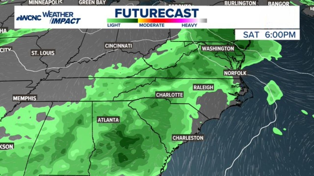
- North Carolina: Charlotte and Raleigh — 50% Saturday, 60% Tuesday — both cities in the moderate to heavy rain zone on the futurecast maps
- South Carolina: Charleston and the Upstate — included in both Saturday and Tuesday rain events
- Georgia: Atlanta on the southern edge of the 6–10 day above-normal precipitation signal
- Virginia: Norfolk and Washington D.C. corridor — moderate rain coverage Saturday at 6 PM
- Tennessee: Memphis area included in the above-average precipitation zone April 27–May 1
- Kentucky and Ohio: Cincinnati corridor showing above-normal rainfall probability in the extended outlook
The Rain Chances Day by Day
The 7-day forecast lays out a clear pattern:
- Wednesday, Thursday, Friday: Completely dry — 0% rain chance across the Charlotte region
- Saturday: First meaningful rain arrives — 50% chance with moderate to heavy coverage shown on the 6 PM futurecast across Charlotte, Raleigh, and the entire Carolina corridor
- Sunday: Rain chance drops to 20% — a brief lull between systems
- Monday: Back to 0% as the pattern briefly clears
- Tuesday: The stronger system arrives — 60% rain chance with widespread moderate rain coverage from Atlanta through Charlotte, Raleigh, Norfolk, and Washington D.C. by 2 PM
Why Saturday and Tuesday Matter So Much for the Carolinas
Charlotte, North Carolina has been running 15 to 20 inches below normal rainfall since October — one of the driest six-month stretches on record across the entire Southeast. Every rain event between now and summer is critical because the region needs 10 to 20 inches spread over 2 to 3 months to meaningfully recover from the drought.
Saturday’s 50% rain chance is encouraging but comes with important context. The forecast text is clear: large totals are not expected from any individual front. This weekend’s rain will help — but it will not break the drought on its own. Think of it as the first deposit into an account that is deeply overdrawn. Every inch matters, but the math requires sustained above-normal rainfall for weeks, not a single weekend event.
What makes Tuesday’s 60% chance more significant is the futurecast imagery. The Tuesday 2 PM map shows a broad swath of moderate to heavy green coverage stretching from Atlanta through Charlotte, Raleigh, and all the way to Norfolk and Washington — a much more organized and widespread rain event than Saturday’s system. If Tuesday delivers meaningfully, the combination of Saturday and Tuesday could produce the first back-to-back rain events the Carolinas have seen in months.
The 6–10 day precipitation outlook for April 27–May 1 is perhaps the most encouraging signal. The green above-average rainfall zone covers Charlotte, Raleigh, Atlanta, Memphis, and Nashville — suggesting that the overall pattern is shifting toward wetter conditions across the drought zone for at least this period. A 30–50% chance of above-average rainfall during this window is genuinely hopeful after months of persistent dryness.
Multi-Day Pattern
The immediate dry stretch through Friday is frustrating but not surprising — the same pattern that has kept the Southeast dry all spring is still in partial control. Saturday marks the first crack in that pattern as a frontal system pushes through. Sunday and Monday see a brief break. Tuesday brings the stronger and more organized rain event. Beyond Tuesday, the long-range signal continues to favor above-normal precipitation into the start of May — the most encouraging extended outlook the Carolinas have seen since the drought began.
What to Watch Next
- Saturday rain totals across Charlotte and Raleigh — whether the 50% chance delivers meaningful accumulation or just light showers
- Tuesday’s system intensity — whether the organized moderate-to-heavy rain coverage on the futurecast map verifies across the full Carolina corridor
- Weekly rainfall totals April 27–May 1 against the drought deficit
- Whether the above-average precipitation signal in the 6–10 day outlook continues into the following week
- Drought monitor updates in early May reflecting any improvement from the weekend and Tuesday rain events
Residents across North Carolina, South Carolina, and Georgia should welcome this weekend’s rain with open arms — and keep realistic expectations. The drought took six months to build. It will take consistent, repeated rain events over many weeks to meaningfully recover. But the pattern is finally trending in the right direction.
WaldronNews.com will continue tracking drought relief rain chances across the Carolinas and Southeast and provide updates as each system approaches.