
Oklahoma and Kansas Face Supercells With Tennis Ball Hail and Tornadoes Thursday Evening as 60 mph Squall Line Targets Iowa and Minnesota
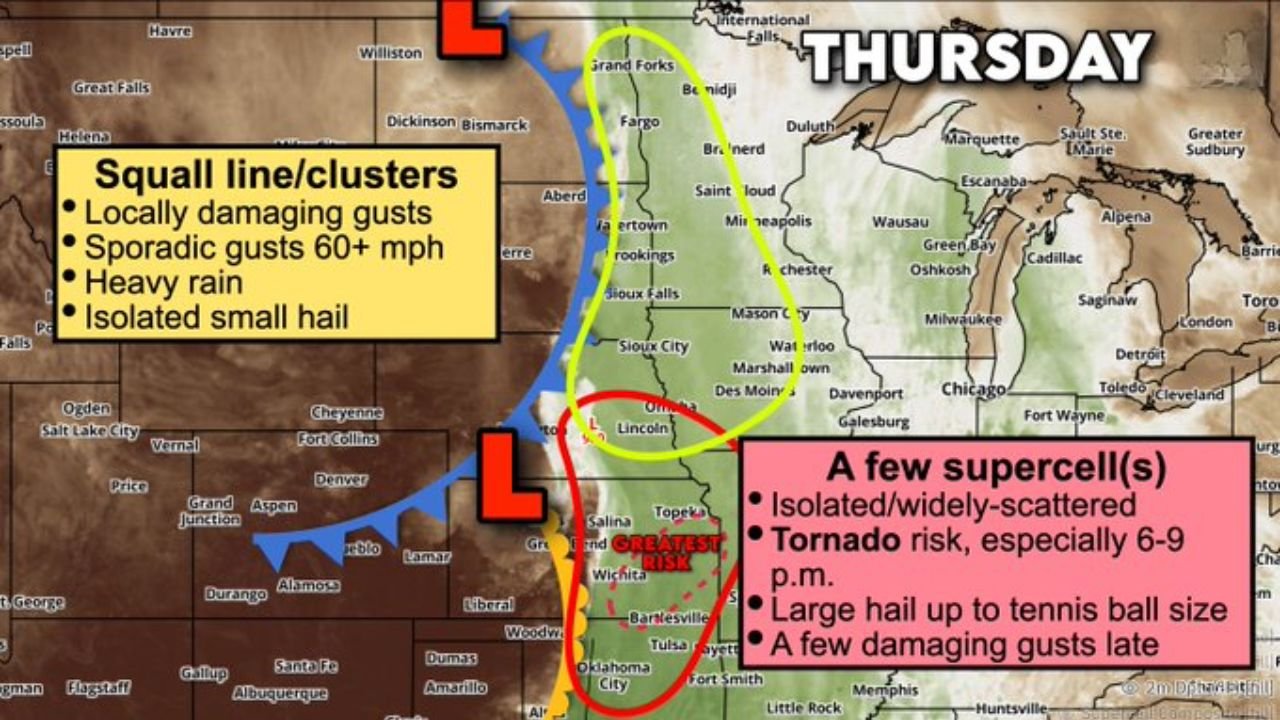
WICHITA, Kansas — Thursday, April 23 is shaping up as a split severe weather day across the Plains and Midwest — with two distinct and dangerous storm modes operating simultaneously. Northern Oklahoma and eastern Kansas face the highest tornado risk from isolated supercells capable of tennis ball-size hail between 6 and 9 PM, while a 60+ mph squall line simultaneously hammers Iowa, Minnesota, and the northern Plains with damaging gusts and heavy rain.
This is a complex, high-threat setup — and the 6–9 PM window Thursday evening is the most dangerous period to watch.
Two Separate Threats — Two Different Regions
Southern Zone — Oklahoma and Kansas (Supercell Threat):
- Northern Oklahoma: Greatest tornado risk of the entire event — isolated supercells possible where the cap breaks
- Eastern Kansas: Wichita and Topeka corridor in the supercell zone
- Western Missouri: Kansas City area on the eastern edge of the supercell threat
- Southwest Iowa: Cannot rule out supercell risk extending into the Omaha metro area
Northern Zone — Iowa, Minnesota, and the Dakotas (Squall Line):
- Iowa: Des Moines corridor — squall line with 60+ mph gusts and heavy rain
- Minnesota: Minneapolis area facing the fast-moving line of severe storms
- South Dakota: Sioux Falls on the western edge of the squall line track
- Wisconsin: Green Bay and Oshkosh on the northern fringe as the line pushes northeast
Primary Threats by Storm Type
Supercells — Kansas and Oklahoma (6–9 PM window):
- Tennis ball-size hail — a secondary surface low in Kansas is generating the wind shear profile needed for hail-producing supercells; tennis ball hail is approximately 2.5 inches in diameter and causes catastrophic vehicle and roof damage
- Tornadoes — the wind profile change with height across Kansas and Oklahoma signals rotation potential for any storm that grows tall enough to tap the jet stream; a couple of tornadoes cannot be ruled out
- Damaging winds late — as supercells eventually merge or bow out, damaging gusts become a secondary threat after 9 PM
Squall Line — Iowa and Minnesota:
- Sporadic 60+ mph gusts — locally damaging straight-line winds along and ahead of the squall line
- Heavy rain — training storm cells ahead of the line capable of brief heavy downpours
- Isolated small hail — embedded within the squall line clusters
Why the 6–9 PM Window Is So Critical for Kansas and Oklahoma
Wichita, Kansas and Tulsa, Oklahoma sit in the zone where a secondary surface low in Kansas is creating a textbook supercell environment Thursday evening. Here is what that means in plain terms: the surface low is pulling winds from the southeast at ground level, while the jet stream is pushing winds from the southwest thousands of feet above. That change in wind speed and direction with height — called wind shear — is exactly what makes thunderstorms rotate. Any storm tall enough to feel both wind layers simultaneously will spin.
The 6 to 9 PM timing is critical because that window combines peak atmospheric instability from daytime heating with the arriving wind shear from the approaching system. Storms firing during this window have everything they need to become violent supercells quickly.
The tennis ball hail threat is particularly serious for vehicles, structures, and anyone caught outdoors. Hailstones of that size fall at speeds exceeding 80 mph and can cause concussions, break windshields instantly, and destroy roofs in seconds. Even a single supercell tracking across a populated area produces millions of dollars in damage.
The uncertainty in this forecast is honest: forecasters acknowledge it is unclear how many storms will actually form, because the cap — a layer of warm air that suppresses storm development — may hold in some areas. But the ingredients are there. If even one or two supercells fire in the right location Thursday evening, the results could be severe.
Multi-Day Pattern
Thursday is the primary severe weather day for this system. The squall line pushes into the Great Lakes and Ohio Valley Thursday night before weakening Friday. The supercell threat in Kansas and Oklahoma is focused in the Thursday afternoon to late evening window before the overall system exits east. A brief quieter period follows for the weekend before the next severe weather pattern targets the Tennessee Valley and Mid-South around Monday, April 27.
What to Watch Next
- Whether the cap breaks across eastern Kansas and northern Oklahoma Thursday afternoon — storm initiation timing determines everything
- Tornado watch issuances for Kansas, Oklahoma, and western Missouri between 4 and 8 PM Thursday
- Hail size reports from the first supercells that fire in the Wichita and Topeka corridors
- Squall line timing for Des Moines and Minneapolis — when 60+ mph gusts arrive
- Storm reports Thursday night as the full picture of Thursday’s outbreak becomes clear
Residents across Kansas, Oklahoma, Iowa, and Minnesota need to be weather-aware all day Thursday — but especially from 6 PM onward. If you are in the Kansas or Oklahoma supercell zone, be inside and away from windows during the evening hours. Tennis ball hail and tornadoes can develop with minimal warning time in environments like this.
WaldronNews.com will continue tracking Thursday’s dual severe weather threat and provide updates as storm initiation and tornado watch issuances develop.