
Oklahoma City and Tulsa Face Softball-Sized Hail Saturday as the Atmosphere Between 15,000 and 28,000 Feet Becomes a Hailstone Factory
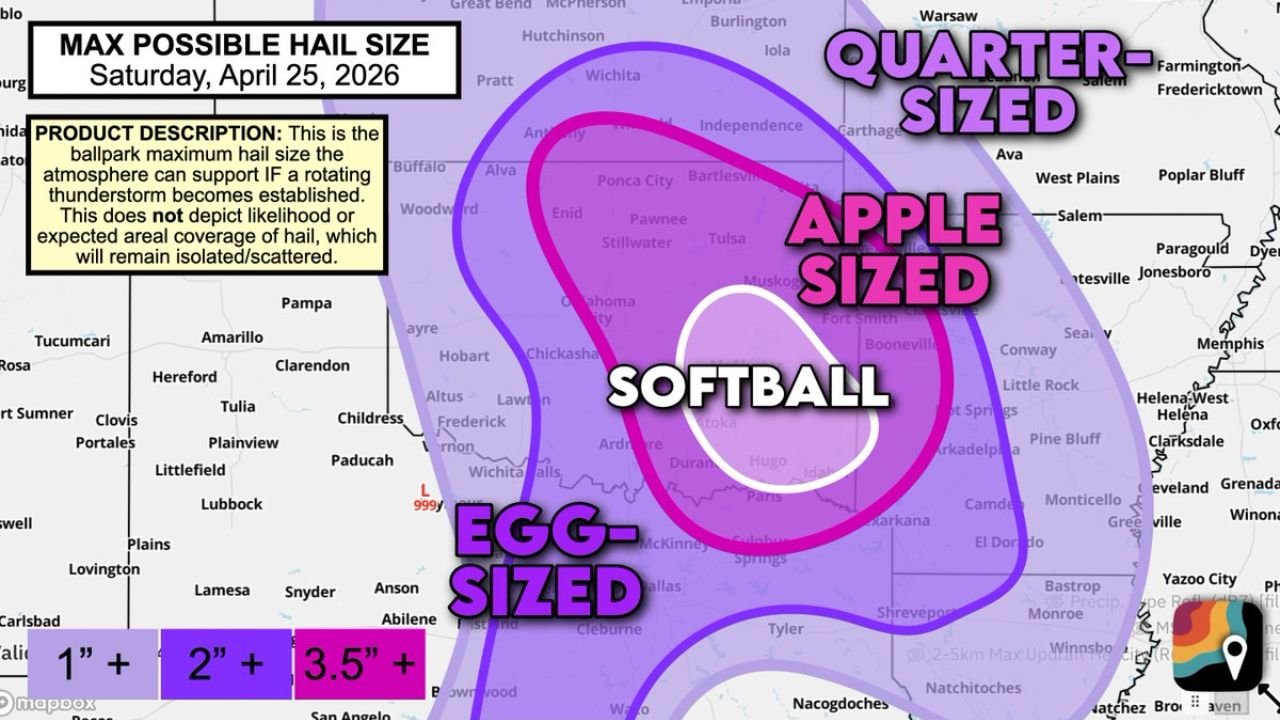
OKLAHOMA CITY, Oklahoma — The hail threat for Saturday, April 25 just got upgraded — and the numbers are sobering. Forecasters are now comfortable calling for hail up to softball size — 4 inches in diameter — with the strongest supercells forming east of I-35 in eastern Oklahoma. The white softball zone on the maximum hail size map sits directly over Oklahoma City, Chickasha, Ardmore, Atoka, and Durant. Apple-sized hail extends east through Tulsa, Fort Smith, and into Arkansas. And egg-sized hail reaching 3.5 inches spreads south toward Dallas and north toward Wichita.
This is not a routine hail day. The atmosphere Saturday has a very specific and unusual combination of ingredients that makes giant hailstone growth not just possible but likely in the strongest storms.
The Hail Size Map — Who Gets What
The map covers a massive swath of the Southern Plains and Mid-South, with hail size potential decreasing outward from the central Oklahoma bull’s-eye:
Softball Zone — 4 inches diameter (white circle):
- Oklahoma: Oklahoma City, Norman, Chickasha, Lawton, Ardmore, Atoka, Durant — the core softball zone runs along and east of I-35 through central and southern Oklahoma
Apple-Sized Zone — 3.5 inches+ (pink/magenta):
- Oklahoma: Tulsa, Stillwater, Ponca City, Enid, McAlester, Hugo
- Arkansas: Fort Smith, Hot Springs — eastern extension of the large hail zone
- Texas: Paris, Sulphur Springs — southeastern edge
Egg-Sized Zone — 2 inches+ (purple):
- Kansas: Wichita, Independence, Bartlesville — northern spread
- Missouri: Joplin, Springfield fringe — far eastern edge
- Texas: Dallas, Waco corridor, McKinney — southern extension
- Arkansas: Little Rock, Jonesboro, Paragould — broad coverage
Quarter-Sized Zone — 1 inch+ (light purple outer ring):
- Kansas: Emporia, Iola — northern fringe
- Missouri: Joplin corridor
- Arkansas: Memphis border area, Clarksdale
- Texas: Tyler, Nacogdoches — deep southern Texas
Why Saturday’s Atmosphere Is Built Specifically to Grow Giant Hail
This is where Saturday separates itself from a typical hail day — and it comes down to four distinct atmospheric factors working together in an unusually cooperative way.
Factor One — Elevated Storms Root Above the Cool Surface Air
Friday’s thunderstorms left behind a shallow layer of cooler air at the surface. Saturday’s storms will likely be elevated — meaning they develop rooted atop this cool shallow layer rather than directly at the surface. Elevated storms are actually less favorable for tornadoes, which is why Saturday’s tornado threat is lower than Thursday’s or Sunday’s. But elevated storms are significantly better at producing very large hail. They spend more of their energy growing hailstones rather than producing rotation near the ground.
Factor Two — Mid-Level Dryness Creates the Perfect Hailstone Growing Environment
The atmosphere Saturday is humid at the surface but not tropical-level humid at the mid-levels. This distinction is critical for hail growth. When mid-level air is slightly dry, supercooled water droplets in the storm’s updraft are smaller — and smaller droplets latch onto growing hailstones more efficiently than large droplets that simply fall as rain. The result is hailstones that accumulate mass faster and grow to larger sizes before falling.
Factor Three — Extreme Storm Fuel at 15,000 to 28,000 Feet
The layer of the atmosphere between 15,000 and 28,000 feet — exactly where hailstones form and grow — is loaded with storm fuel Saturday. Temperatures in this layer will run between -22 and +14 degrees, which forecasters describe as the sweet spot for hailstone formation. Strong upward-moving air in this layer suspends hailstones for longer, giving them more time to accumulate layers of ice before they become heavy enough to fall. More suspension time means larger final hail size.
Factor Four — Steep Temperature Drop With Height
A steep lapse rate — a rapid cooldown of temperature as you go higher in the atmosphere — makes storm updrafts more explosive and efficient. Saturday’s atmosphere has this characteristic, which directly translates to stronger updrafts capable of keeping larger and heavier hailstones suspended longer. A stronger updraft is essentially a more powerful hailstone elevator — it can hold up a softball where a weaker updraft could only hold a golf ball.
The Warm Front Boundary Adds One More Ingredient
Friday’s thunderstorm outflow is lifting northward Saturday as a warm front, and that boundary is not just a meteorological footnote — it is an active ingredient. Surface boundaries provide extra low-level turning and convergence that can focus storm development and intensify existing supercells as they cross or interact with the boundary. The surface low sitting just southwest of Wichita Falls, Texas is pumping moisture northward directly into this boundary zone, feeding the storms additional fuel as they mature.
What 4-Inch Softball Hail Actually Does
A softball is 4 inches in diameter and weighs approximately 6 ounces. Falling at terminal velocity from a mature supercell — roughly 100 mph — it carries enough kinetic energy to punch through car hoods, shatter windshields completely, crack roofing tiles, and break through skylights. A single supercell can lay down a softball hail swath 2 to 5 miles wide and 10 to 20 miles long. Vehicles caught in that swath are typically considered total losses by insurance adjusters. Roofs that take a direct softball hail event often require full replacement.
Apple-sized hail at 3.5 inches is only marginally less destructive — still capable of punching through car roofs and causing significant structural damage to anything exposed outdoors.
Before Saturday Afternoon Arrives
- Get every vehicle under a roof right now — garage, carport, parking structure; a car cover does nothing against softball hail
- The softball zone covers Oklahoma City through Ardmore — if you live or work anywhere in this corridor, treat vehicle protection as urgent today
- Tulsa and Fort Smith are in the apple-sized zone — the same vehicle protection urgency applies
- Dallas and northern Texas residents should monitor radar Saturday afternoon — the egg-sized zone reaches into your area and storms can produce larger hail than forecast in localized areas
- Do not be outside when storms approach — softball hail is life-threatening to anyone caught in the open
WaldronNews.com will continue tracking Saturday’s hail-producing supercells across Oklahoma and provide updates as storms develop and hail reports come in.