
Oklahoma Could Be Sunny and Tornado-Warned at the Same Time Friday: Here Is Why the Cap Makes This Day So Unpredictable
OKLAHOMA CITY, Oklahoma — Friday’s forecast for Oklahoma sounds almost contradictory: mostly sunny skies with a slight chance of strong tornadoes. That is not a mistake — it is exactly what forecasters are dealing with, and understanding why makes this one of the more unusual and dangerous setups of the week.
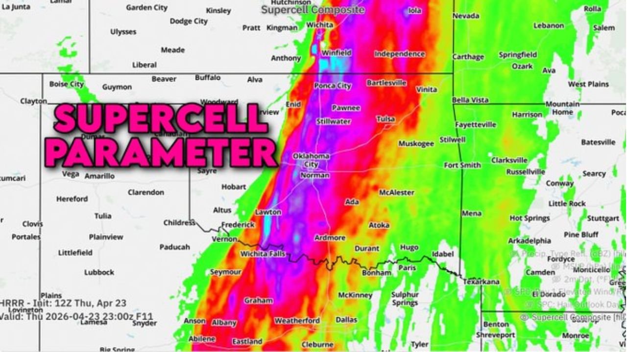
The atmosphere over Oklahoma on Friday is sitting on a knife’s edge. Everything needed for violent severe weather is in place — extraordinary supercell composite parameter values running from Wichita Falls through Oklahoma City to Ponca City, deep Gulf moisture surging east of the dryline, and a volatile overlap of all severe weather ingredients. The only thing standing between a quiet Friday and a violent tornado outbreak is a strong atmospheric cap that is currently holding storms back. If that cap holds all day, Oklahoma stays quiet. If it cracks — even briefly, even in one spot — what comes out the other side could be high-end and severe.
The Dryline Is the Dividing Line
The maps tell the story visually. A sharp dryline runs north to south directly through Oklahoma — dry desert air on the west side, deep humid Gulf moisture on the east. Oklahoma City, Norman, Tulsa, Ponca City, and Bartlesville all sit on the humid, storm-fuel side of that boundary.
On the supercell composite parameter map, the values along and east of that dryline through Oklahoma are extreme — the kind of numbers that only appear a handful of times per season. Lawton, Oklahoma City, Norman, Enid, Ponca City, and the corridor running north through Winfield, Kansas are all inside what is essentially maximum supercell territory. The atmosphere in this zone has everything a tornado-producing storm could want: instability, wind shear, and moisture all stacked in the same column of air.
What the Cap Is Doing and Why It Matters
The cap map shows the problem and the opportunity simultaneously. A yellow oval labeled “Mostly Capped — Very Low Storm Risk” covers the same corridor where the supercell composite values are screaming. That cap is a layer of warm air sitting in the mid-levels of the atmosphere that acts like a lid on a pressure cooker. Storms cannot punch through it under normal circumstances.
But caps weaken. Afternoon heating erodes them from below. Upper-level energy approaching from the west can lift them from above. And drylines — exactly like the one sitting over Oklahoma right now — are notorious for finding weak spots in the cap and allowing a single storm to break through while everything around it stays quiet.
That one storm, if it fires in this environment, immediately has access to one of the most extreme supercell parameter fields seen this week. It does not gradually become dangerous — it becomes dangerous within minutes of initiation. Forecasters describe this scenario specifically as “very high-end and severe” if initiation occurs.
The Official Risk and Who Is Inside It
The formal outlook reflects the uncertainty honestly. Central and eastern Oklahoma from Oklahoma City north through Tulsa and Ponca City carries a Level 2 of 5 Slight Risk — acknowledging the real severe weather potential while reflecting the cap uncertainty. South of that zone through Lawton, Wichita Falls, and toward Graham, Texas, the risk drops to a Level 1 of 5 Marginal — the cap is even stronger here but the threat is not zero.
The Slight Risk zone includes:
- Oklahoma: Oklahoma City, Norman, Tulsa, Stillwater, Ponca City, Enid, Bartlesville
- Kansas: Winfield, Independence — northern extension of the volatile parameter zone
- Arkansas: Fayetteville, Fort Smith — eastern edge where storms could track if they fire
The Marginal Risk zone extends south through:
- Oklahoma: Lawton, Ardmore, Durant
- Texas: Wichita Falls, Graham, Bonham — southern fringe where cap is strong but not impenetrable
If a Storm Fires — What Happens Next
This is the part that demands attention regardless of the low storm probability. The supercell composite parameter values in the Oklahoma City corridor are not slightly elevated — they are in the top tier of what this region sees all year. A storm that breaks through the cap in this environment does not produce marginal severe weather. It produces the conditions for a significant, potentially violent tornado almost immediately.
The scenario is comparable to a dam holding back an enormous reservoir. The dam — the cap — is strong today. But if any crack opens, the release is not gradual. It is immediate and powerful. One supercell in this environment has the potential to produce an EF2 or stronger tornado with very little warning time because the atmosphere is so loaded that storm intensification happens faster than normal.
The mostly sunny skies make this psychologically dangerous too. People who look outside Friday afternoon and see blue sky tend to dismiss severe weather risk. In a capped environment with extreme instability, that blue sky can turn to tornado warning in under 30 minutes once initiation begins.
The Broader Week This Fits Into
Friday’s Oklahoma cap scenario sits between Thursday’s active Kansas tornado day and Saturday’s reload across the Southern Plains. The atmosphere is cycling through this region repeatedly — Thursday brought TOR:CON 5 to Wichita, Friday tests Oklahoma’s cap, and Saturday brings severe storms back to Oklahoma City and Wichita again. The region is not getting rest between events.
Keep Watching the Sky Friday Afternoon
- The cap holds through the morning with very low storm risk — but the afternoon heating window from 2 to 6 PM is when the cap is most vulnerable
- Any storm that initiates along the dryline near Oklahoma City or Norman should be treated as immediately dangerous given the extreme supercell parameter values in that zone
- Tulsa and Ponca City are on the eastern edge of the parameter bull’s-eye — if storms fire and track east, these cities are in the path
- Blue skies Friday afternoon do not mean the threat has passed — watch radar actively through the evening
- If a Tornado Warning is issued anywhere in the Slight Risk zone Friday, take it with the same urgency as a higher-risk day — the atmosphere’s energy does not care about the outlook category
Oklahoma on Friday is the definition of a high-ceiling, low-probability severe weather day. The cap will likely hold. But if it does not, what follows will be significant.
WaldronNews.com will continue monitoring Friday’s cap evolution across Oklahoma and provide updates if initiation occurs.