
Kansas, Oklahoma and Missouri Severe Weather Outbreak Sunday as Wichita, Tulsa and Oklahoma City Enter the High-End Red Zone
WICHITA, Kansas — A severe weather outbreak is expected across the Central Plains this Sunday, April 26, and Wichita, Tulsa, and Oklahoma City are sitting inside the highest-risk red zone on the outlook map. A potent trough and a highly primed atmosphere are in place across Kansas, Oklahoma, and Missouri — capable of producing tornadoes, very large hail, and damaging winds. The only remaining question is whether storms initiate cleanly. If they do, this setup has the ingredients to quickly escalate into a high-end, dangerous outbreak.
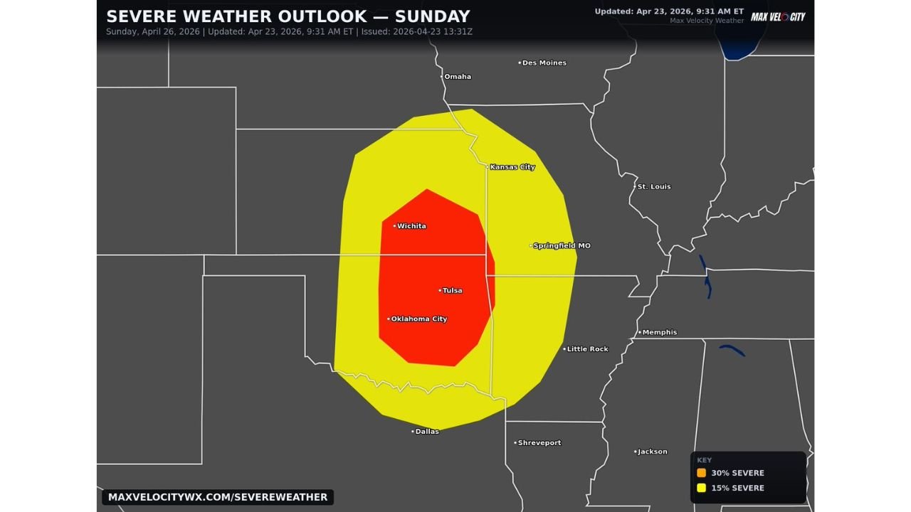
The red zone on Sunday’s outlook covers a 30% severe weather probability corridor centered directly over the Wichita-to-Oklahoma City corridor — one of the most tornado-prone regions on the planet sitting inside a loaded atmospheric environment.
States and Cities in Sunday’s Outbreak Zone
Red Zone — 30% Severe, Highest Risk:
- Kansas: Wichita — dead center of the red zone; all severe hazards on the table
- Oklahoma: Oklahoma City, Tulsa — both major cities inside the core high-risk area
- Missouri: Southern portions approaching Springfield — on the eastern edge of the red zone
Yellow Zone — 15% Severe, Broad Threat:
- Kansas: Kansas City, Topeka — northern Kansas inside the outer severe threat area
- Nebraska: Southern Nebraska including Omaha fringe — northern edge of the yellow zone
- Missouri: Kansas City, Springfield — broad severe weather threat
- Arkansas: Little Rock — southeastern fringe of the 15% zone
- Texas: Dallas corridor — southern edge of the outer threat zone
Primary Threats
- Tornadoes — the atmospheric setup supports significant tornado development if storms fire as discrete supercells; this is not a marginal tornado threat
- Very large hail — the primed environment supports hailstone growth well above baseball size in the most intense supercells
- Damaging straight-line winds — widespread wind damage possible across both the red and yellow zones
- High-end outbreak potential — the only thing standing between a routine severe weather day and a major outbreak is storm initiation; if the cap breaks and storms fire cleanly, the ceiling on this event is very high
- Storm initiation uncertainty — the cap may suppress storm development in some areas, but any cell that does fire will immediately have access to exceptional atmospheric fuel
Why This Matters for Oklahoma City and Wichita
Oklahoma City and Wichita are two of the most experienced severe weather cities in America — but experience does not mean immunity. Both cities are sitting inside a red zone where the atmosphere has been described as highly primed, meaning every ingredient needed for violent severe weather is already in place before a single storm cloud forms.
The phrase forecasters are using — “if storms fire, this could quickly escalate into a high-end event” — is not hedging language. It is an honest acknowledgment that the atmospheric energy available Sunday is so large that the difference between a manageable severe weather day and a historic outbreak comes down to one variable: whether the cap weakens enough for storms to break through.
A potent trough is the trigger system. When it arrives Sunday, it will attempt to lift the cap and force storm initiation. If that lifting is strong enough across the red zone, supercells will develop rapidly, and they will immediately have access to all the shear, moisture, and instability needed to become long-track tornado producers. The atmosphere is essentially a loaded spring — the trough is what releases it.
For residents of Wichita, Tulsa, and Oklahoma City, Sunday demands full preparation regardless of uncertainty. A setup this loaded does not give second chances once storms develop.
Multi-Day Pattern
Sunday’s outbreak potential is sandwiched between Saturday’s hail-focused dryline event and Monday’s even larger tornado threat targeting the Mid-South. Three consecutive days of significant severe weather across the Plains and Mid-South — Saturday, Sunday, and Monday — represent one of the more relentless stretches of severe weather seen across this region in years.
After Monday’s event pushes through Tennessee and Mississippi, the pattern briefly pauses before another significant setup emerges around Thursday, May 1 targeting Mississippi, Alabama, and Louisiana. The atmosphere is not slowing down — it is cycling through back-to-back dangerous events with almost no recovery time.
What to Watch Next
- Watch Sunday morning updates closely — storm initiation timing and cap break location will be the deciding factor for how bad this gets
- If storms fire before 3 PM Sunday, the threat escalates significantly — afternoon initiation gives supercells more daylight time to organize and track long distances
- Wichita and Oklahoma City residents should have shelter plans finalized before Sunday morning — do not wait for storm warnings to start preparing
- Track the red zone’s eastern edge — Springfield, Missouri and Little Rock, Arkansas could be pulled deeper into the threat if the system tracks slightly east
- Monday’s Mid-South outbreak follows within 12 hours of Sunday’s Plains event — the most dangerous 48 hours of the week run back to back
Residents across Kansas, Oklahoma, and Missouri need to treat Sunday as a genuine severe weather emergency in the making — the atmosphere is loaded and this outbreak could go high-end fast.
WaldronNews.com will continue tracking Sunday’s developing severe weather outbreak and provide updates throughout the day as storm initiation becomes clearer.