
Kansas Tornado Threat Erupts at 4 PM Today as Supercells Target Wichita to Oklahoma City With Intense Tornado Risk After Dark
WICHITA, Kansas — The tornado threat across central Kansas down through Oklahoma City is becoming more defined by the hour, and the window of maximum danger opens this afternoon between 4 and 6 PM. Supercells are expected to erupt along a cold front and dryline running north to south, moving into an intensifying low-level jet right at the most dangerous time of day — the magic hour when atmospheric energy peaks and tornado-producing conditions reach their highest potential.
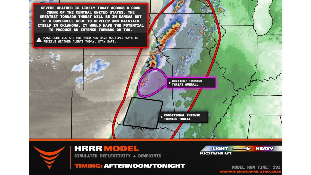
Wichita sits inside the greatest overall tornado threat zone. Oklahoma City faces a more conditional but potentially more intense threat — if a supercell develops and holds together in Oklahoma, it would have the ingredients to produce an intense tornado or two.
Cities in Today’s Tornado Threat Zone
Greatest Tornado Threat — Central Kansas:
- Kansas: Wichita, Hutchinson, Newton, Emporia — highest overall tornado probability; supercells most likely to fire and sustain here
- Kansas: Salina, Manhattan — northern Kansas inside the threat corridor along the cold front
Conditional Intense Tornado Threat — Central Oklahoma:
- Oklahoma: Oklahoma City, Norman, Lawton — conditional threat with a very high ceiling; if a supercell fires and maintains itself here, intense tornadoes are possible
- Oklahoma: Tulsa — on the northeastern edge between both threat zones
Broader Severe Weather Zone:
- Missouri: Joplin, Springfield — eastern fringe as storms track into the evening
- Nebraska: Southern portions — northern end of the cold front storm corridor
Primary Threats
- Significant tornadoes — the greatest overall tornado threat is centered on central Kansas; supercell development is most confident here
- Conditional intense tornadoes in Oklahoma — the atmosphere over OKC has extremely high ceiling in terms of tornado significance; one sustained supercell could produce a violent, long-track tornado
- 4 to 6 PM storm initiation — supercells erupt along the cold front and dryline during this window, then immediately move into the strengthening low-level jet
- Magic hour intensification — storms firing at 4 to 6 PM are perfectly timed to intensify as the low-level jet ramps up after sunset, extending the tornado threat into the overnight hours
- Damaging winds and large hail alongside tornadoes across the entire corridor
Why This Matters for Wichita and Oklahoma City
The setup today has two distinct characters depending on where you are.
In central Kansas — particularly Wichita and the surrounding area — this is the highest-confidence tornado zone. Storm initiation here is not conditional the way it is further south. Supercells are expected to fire along the cold front boundary and they will have immediate access to excellent wind shear, strong instability, and the approaching low-level jet. These storms fire in the afternoon and stay dangerous well into the night as they track east.
In central Oklahoma — the Oklahoma City to Norman corridor — the situation is different and in some ways more dangerous. The tornado threat here is described as conditional because the cap may hold longer before storms break through. But that same cap has been bottling up extraordinary instability all day. If a supercell finally punches through that cap and organizes in the Oklahoma warm sector, it has access to even deeper moisture and higher instability than the Kansas zone. That is why forecasters say the significance ceiling is very high for Oklahoma — a sustained supercell here has the potential for an intense tornado or two that could be among the strongest of the entire outbreak.
The critical variable for OKC is whether any individual storm can stay discrete — meaning it holds together as a single rotating supercell rather than merging with neighboring storms into a squall line. Discrete supercells produce the most violent tornadoes. If storm mode cooperates, the threat for Oklahoma City could rival or exceed the Kansas threat despite being more conditional at the start.
Multi-Day Pattern
Today’s Kansas-Oklahoma tornado threat is the third consecutive day of significant severe weather across the Central Plains, following Thursday’s dryline supercells and Saturday’s hail event. After today’s storms push east tonight, the pattern barely pauses before Monday, April 27 delivers the largest and most widespread tornado threat of the entire stretch — targeting Tennessee, Arkansas, and Mississippi with a full outbreak that has been building in the data for days.
Today is serious. Monday may be worse. The Plains and Mid-South are in the most active and dangerous stretch of the spring season.
What to Watch Next
- 4 PM is the start of the initiation window — be in shelter-ready mode in Wichita and central Kansas before then
- Watch for Oklahoma City supercell development closely — cap break timing there determines how dangerous the southern threat becomes
- Storms moving into the low-level jet after 6 PM will intensify — tornado warnings issued tonight should be taken with maximum urgency
- Track storm mode carefully — discrete supercells mean violent tornadoes; a merging squall line shifts the primary threat to damaging winds
- Monday’s Mid-South outbreak follows within 18 hours — residents in Arkansas and Tennessee should be finalizing preparations right now
Residents from Wichita to Oklahoma City need to be weather-ready before 4 PM today — the tornado threat is real, the timing is now, and the potential ceiling on this event is high.
WaldronNews.com will continue tracking today’s tornado threat across Kansas and Oklahoma and provide live updates as supercells develop this afternoon and evening.