
Missouri, Illinois and Arkansas Monday Severe Weather Outbreak Targets St. Louis and Springfield as Plains Storm Parade Rolls East
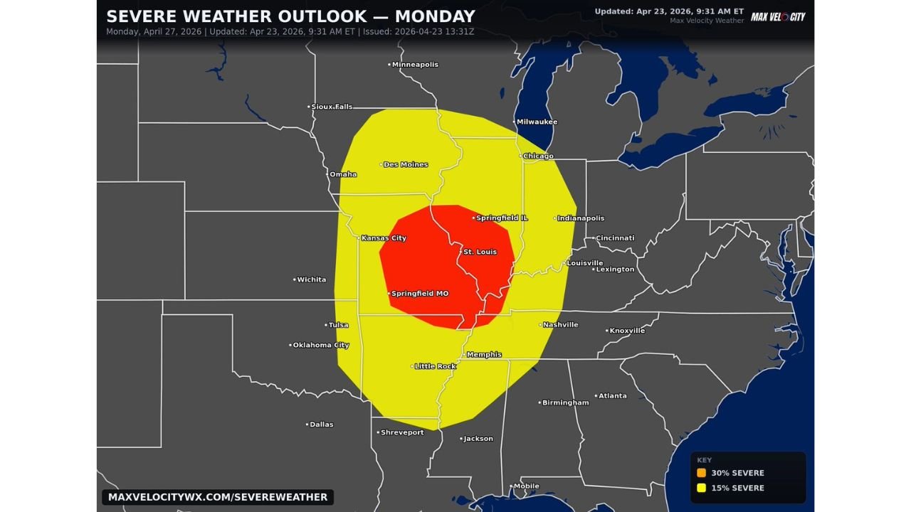
ST. LOUIS, Missouri — The severe weather is not done. After a punishing weekend across Kansas and Oklahoma, the storm parade rolls east on Monday, April 27 — and now Missouri, Illinois, and Arkansas are in the crosshairs. A 30% severe weather corridor is centered directly over St. Louis and Springfield, Missouri, with multiple supercells expected to bring damaging winds, very large hail, and tornadoes to a region that watched Sunday’s Plains outbreak from a distance. Monday is their turn.
The red zone on Monday’s outlook sits over one of the most populated corridors in the Midwest — Kansas City through St. Louis and south through Springfield into northern Arkansas — and the setup demands the same level of attention that Wichita and Oklahoma City gave Sunday.
The Red Zone — Who Is Most Exposed Monday
The 30% severe corridor — the highest risk on this map — covers a tight bull’s-eye running from Kansas City east through St. Louis and south to Springfield, Missouri. Every city inside that red polygon faces the full suite of hazards: tornadoes, very large hail, and destructive winds from multiple supercells moving through.
Missouri takes the direct hit. St. Louis and Springfield are the two most prominent cities named inside the core. Kansas City sits on the western edge of the red zone — close enough that any westward wobble in the storm track puts it squarely in the worst of it.
The 15% yellow zone extends the threat considerably further:
- Illinois: Chicago, Springfield IL, Indianapolis fringe — northern and eastern spread of the severe threat
- Iowa: Des Moines, southern Iowa — northern edge of the yellow zone
- Nebraska: Omaha area — catching the northwest fringe
- Arkansas: Little Rock, Memphis border area — southern extension of the threat
- Tennessee: Memphis, Nashville on the southeastern fringe
- Indiana: Indianapolis, Louisville corridor — eastern edge as storms track overnight
The Atmosphere Behind Monday’s Threat
Sunday’s Kansas-Oklahoma storms do not exhaust the atmosphere — they ride ahead of it. The same potent trough that fueled Sunday’s supercells continues tracking east overnight, dragging its energy directly into Missouri and Illinois by Monday. A fresh surge of Gulf moisture replaces what Sunday’s storms consumed, and the low-level jet repositions itself squarely over the Missouri-Arkansas corridor.
The result is what forecasters describe as a potent environment — not a weakened, leftover system but a fully loaded second-day setup that rivals what the Plains saw on Sunday. Multiple supercells are expected, meaning the threat is not confined to one storm track. Several separate rotating storms could be active simultaneously across the red zone, each capable of producing tornadoes, large hail, and damaging winds independently.
This is what makes Monday particularly dangerous for St. Louis and Springfield. Sunday had one primary initiation zone. Monday has multiple supercell potential across a wider area, which means the threat window is both longer and harder to pin to a single location.
St. Louis Has Reason to Take This Seriously
St. Louis does not experience significant tornado outbreaks as frequently as Kansas or Oklahoma, which can create a false sense of security when the atmosphere loads up like this. But the city and its suburbs sit on Monday’s bull’s-eye with no geographic protection — flat terrain in all directions allows supercells to travel long distances without weakening, and the Missouri river valley can actually channel storm energy in ways that enhance tornado longevity.
Springfield, Missouri faces an equally direct threat. It sits near the southern end of the red zone where the storm environment intersects with the deepest moisture return from the south — a location that historically produces some of Missouri’s most significant tornado events.
Monday Completes a Three-Day Outbreak Sequence
Saturday brought hail to Texas and Oklahoma. Sunday brought tornadoes to Kansas and Oklahoma. Monday shifts the entire severe weather theater east into Missouri, Illinois, and Arkansas. This three-day sequence is being driven by a single large-scale atmospheric pattern — one trough, one moisture surge, three separate outbreak days in three different regions.
After Monday’s storms clear eastward into Indiana and Tennessee overnight, the pattern briefly relaxes — but only briefly. Another significant setup is already emerging for Thursday, May 1 targeting the Deep South.
Get Ahead of This Before Monday Morning
- St. Louis and Springfield, Missouri residents should treat Monday exactly as Wichita treated Sunday — full preparation before storms arrive, not after
- Multiple supercells mean tornado warnings could be issued across several counties simultaneously — know your shelter before the first warning drops
- The threat extends into Monday night as storms track east toward Illinois and Indiana — overnight severe weather is the most dangerous scenario
- Arkansas and Memphis are on the southern fringe but still inside the 15% zone — do not dismiss the threat because you are outside the red
- Watch Monday morning updates closely — storm initiation timing will sharpen and the red zone may expand or shift
The severe weather week is not over. Missouri, Illinois, and Arkansas are next — and Monday’s setup has everything it needs to be a high-impact day.
WaldronNews.com will continue tracking Monday’s severe weather threat and provide updates as the outlook evolves through the weekend.