
Kansas, Arkansas and Missouri Face 5-Day Severe Weather Marathon as TOR:CON 5 Hits Wichita Today and Little Rock Takes All Hazards Friday
WICHITA, Kansas — This is not a one-day severe weather event. A five-day severe weather marathon is now underway across the Heartland and Deep South, running from Thursday through Monday and hitting a different region each day. Wichita opens the week with a TOR:CON 5 tornado probability rating today. Little Rock, Shreveport, and Jackson absorb all severe hazards Friday. Oklahoma City and Wichita reload Saturday and Sunday. And by Monday, St. Louis, Evansville, and Springfield close out what may be the most dangerous five-day stretch across the Central United States this spring.
Each day is a separate event. Each day has its own bull’s-eye. And the atmosphere is not weakening between rounds.
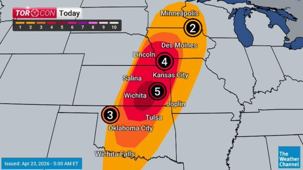
Today — Wichita TOR:CON 5, Minnesota to Oklahoma Active
The highest tornado probability on today’s map sits directly over Wichita, Kansas with a TOR:CON 5 — meaning a 50% chance of a tornado within 50 miles. That is the peak value on the entire map today. Surrounding cities tell the full story of how wide this threat spreads:
- Wichita, Kansas — TOR:CON 5 — the bull’s-eye; tornadoes, large hail, damaging winds all on the table
- Kansas City — TOR:CON 4 — serious threat just to the north; Joplin also in this zone
- Lincoln, Nebraska — TOR:CON 4 — northern Plains pulled into today’s corridor
- Oklahoma City — TOR:CON 3 — conditional but capable of intense tornadoes if cap breaks
- Minneapolis — TOR:CON 2 — outer fringe; severe storms still possible this far north
- Salina, Wichita Falls — inside the core threat corridor running north to south through the Central Plains
Friday — Little Rock, Shreveport and Jackson Get All Hazards
The threat shifts south and east Friday into the ArkLaTex and Mid-South. The severe ingredients map for Friday shows a concentrated all-hazards zone — tornadoes, very large hail, and damaging winds simultaneously possible — centered over Little Rock, Shreveport, Jackson, and Alexandria. The red severe ingredients zone stretches from Dallas and Waco north through Oklahoma City and east to Oxford, Mississippi.
Little Rock and Shreveport are the named cities sitting inside the highest-concentration zone Friday. Jackson, Mississippi is on the eastern edge. Houston is on the southern fringe. This is a region that has been quiet for weeks — and Friday is when that quiet ends abruptly.
Saturday — Oklahoma City and Wichita Reload
Saturday brings severe thunderstorms back to Oklahoma and Kansas — the same cities that faced the worst of Thursday’s outbreak. The likely severe storm zone covers Wichita, Oklahoma City, Woodward, and Garden City. A secondary possible zone extends south toward Dallas, Waco, and east toward Fort Smith and Little Rock.
The atmosphere does not fully recover between Thursday and Saturday. What Saturday lacks in Thursday’s raw tornado potential it makes up for in widespread hail and damaging wind coverage across the Southern Plains.
Sunday — Wichita, Tulsa and Oklahoma City Again; Northwest Arkansas Added
Sunday keeps Wichita, Tulsa, and Oklahoma City in the likely severe storm zone for the third time in four days. The setup expands eastward with Fort Smith and Northwest Arkansas now pulled into the core threat. A broader possible zone reaches Kansas City, Springfield, Little Rock, and down to Texarkana.
Tulsa moves from the fringe to the center of Sunday’s threat — a notable shift from Thursday’s setup that kept it on the edge.
Monday — St. Louis, Evansville and Springfield Close Out the Week
The entire severe weather theater shifts east Monday into the Mid-Mississippi and Ohio River Valleys. St. Louis and Springfield, Missouri sit inside the 30% severe corridor. Evansville, Indiana is specifically named as a likely target. Memphis and Little Rock are on the southern fringe. Chicago and Milwaukee are on the outer edge of the broader threat zone.
Monday is when residents who watched four days of Plains and Mid-South storms from a distance finally face their own direct threat.
This Is a Marathon — Five Days, Five Regions, One Continuous Pattern
What is driving all five days is a single large-scale atmospheric pattern — a persistent trough digging into the Central U.S. that is pulling Gulf moisture north repeatedly while cycling disturbances through the flow one after another. The atmosphere refuels between each event just enough to support the next round.
The danger of a multi-day outbreak like this is alert fatigue. After Thursday and Friday, residents in Oklahoma and Kansas may feel like the worst is over going into Saturday and Sunday. It is not. And Missouri and Illinois residents watching five days of storms to their west may underestimate Monday’s direct threat. Do not let familiarity become complacency — each day on this list is a standalone dangerous event.
What Every Household Needs to Do Before Friday
- Wichita and central Kansas — today is the most dangerous day of your week; TOR:CON 5 means be shelter-ready before afternoon
- Little Rock, Shreveport, Jackson — Friday is your day; all hazards on the table; prepare tonight and tomorrow morning
- Oklahoma City and Tulsa — you face threats Saturday and Sunday back to back; rest is not recovery when the atmosphere reloads this fast
- St. Louis and Evansville — Monday looks serious; use the weekend to prepare while watching the Plains events unfold
- Every household in every named city should have multiple ways to receive tornado warnings — phone alerts, weather radio, and a plan for where to go in the middle of the night
Five days. One continuous outbreak. The Heartland and Deep South need to be ready from right now through Monday night.
WaldronNews.com will track every day of this outbreak and provide updates as each event develops.