
West Alabama Gets Gusty Storms Tonight Before the System Weakens — Here Is What Tuscaloosa, Birmingham and Mobile Should Actually Expect
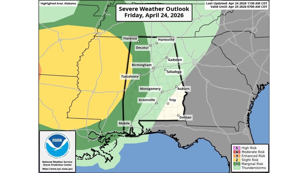
BIRMINGHAM, Alabama — An organized band of showers and storms is arriving across Alabama tonight, and while the SPC has issued a Marginal Risk for the western third of the state and a Slight Risk near the Mississippi border, this is not a major severe weather event for most of Alabama. The threat is real but limited, and it is concentrated in the western portions of the state during the early overnight hours before the system weakens as it pushes east.
Tuscaloosa and areas near the Mississippi border face the highest exposure tonight. Birmingham, Huntsville, and eastern Alabama cities including Gadsden, Talladega, Auburn, and Dothan are in much better shape and will mostly see rain without significant severe weather.
What the Outlook Actually Shows
The SPC outlook for Friday, April 24 valid through Saturday morning draws a clear picture of where the threat concentrates and where it drops off rapidly.
The Slight Risk zone, shown in yellow, sits west of Alabama and clips only the far western edge of the state near the Mississippi border. This is where the storms arrive with the most energy and the highest chance of producing gusty winds. Florence, Tuscaloosa, and the Birmingham western suburbs are on or near the edge of this zone.
The Marginal Risk in green covers the western third of Alabama including Florence, Decatur, Tuscaloosa, Birmingham, and Montgomery. Storms in this zone can produce strong, gusty winds early tonight but the threat is not especially high and a tornado is not expected anywhere in the state tonight.
Everything east of a line roughly from Huntsville through Talladega to Montgomery carries only a general thunderstorm risk with no formal severe weather designation. Gadsden, Auburn, Troy, Dothan, and Mobile fall into this lower-threat eastern zone.
Why the Storms Weaken as They Cross Alabama
The key phrase in tonight’s forecast is that storms should weaken as they move deeper into the state. This is not unusual for this type of setup. The instability and dynamic atmospheric support that keeps storms organized near the Mississippi border diminishes as the storm system moves east across Alabama. Limited instability means the storms lose their fuel source progressively, and without that energy they cannot maintain the organized structure needed to produce significant wind gusts or any tornado threat.
This is why Huntsville, Gadsden, and eastern Alabama are in a much better position tonight than Tuscaloosa and western communities. By the time tonight’s band reaches those areas, it will be a weaker, rain-dominated system rather than an organized severe threat.
After Tonight — A Mostly Dry Friday
Rain will diminish quickly in the early morning hours Saturday, and much of the day will be dry across Alabama. A few widely scattered showers and thunderstorms are possible during Saturday afternoon but these are not organized or particularly threatening. Saturday is essentially a reset day before the larger and more significant storm pattern develops for the following week.
Alabama residents should be aware that while tonight is manageable, the severe weather season is just getting started for this region. The broader multi-day outbreak pattern affecting the Plains and Mid-South through the end of April will eventually reach Alabama in more significant form during the week ahead.
Tonight requires awareness, not alarm. Check alerts if you are in western Alabama or near Tuscaloosa before bed, and be ready to move to an interior room if a warning is issued. For everyone east of Birmingham, tonight is a rain event with no significant severe weather expected.
WaldronNews.com will continue tracking tonight’s storms across Alabama and provide updates as the system moves through the state.