
Monday April 27 Storms Generate 490 Total Reports Across Illinois, Indiana and Kentucky as Cap Limits Tornado Potential but 265 Wind Reports Confirm Widespread Damage
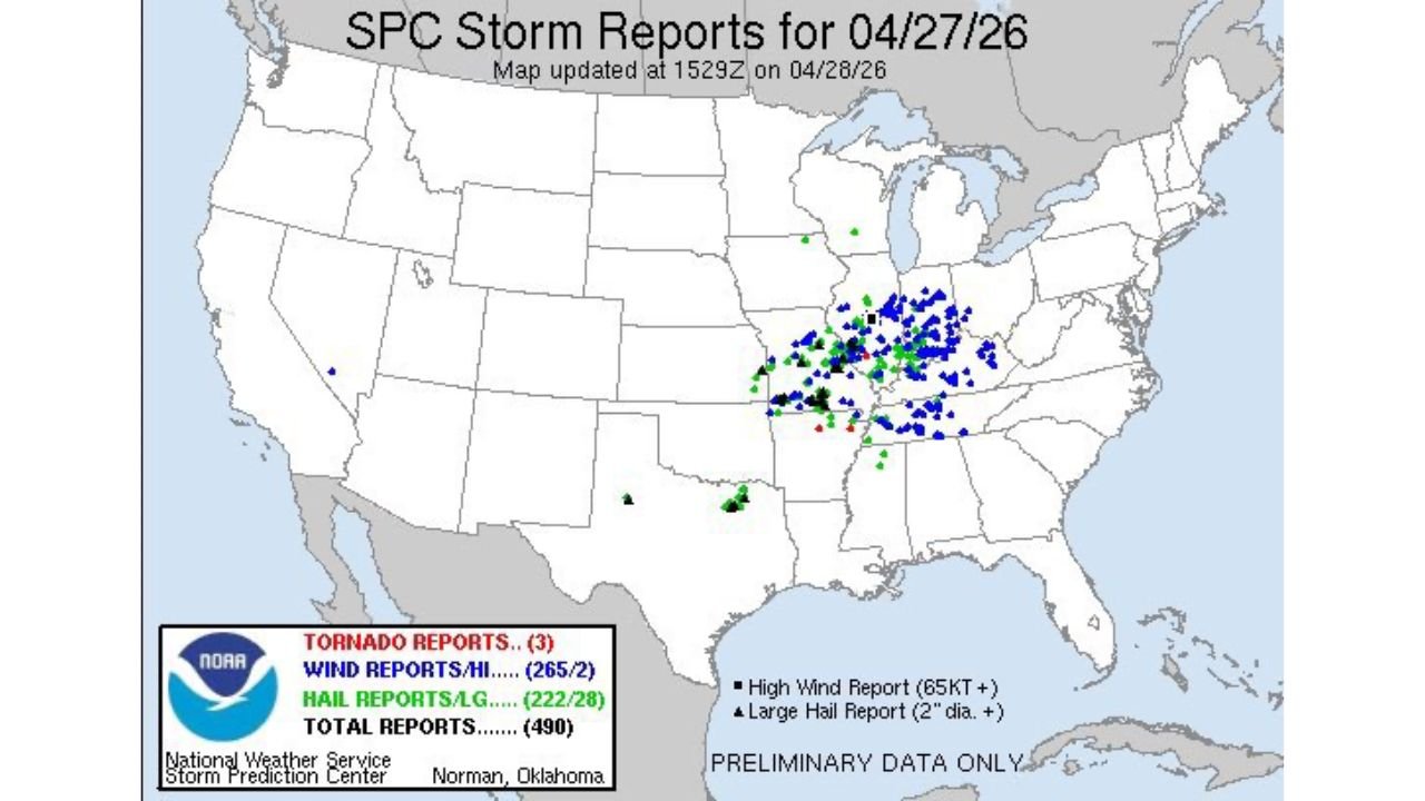
CHICAGO, Illinois — The final storm report tally from Monday April 27 is in, and it tells the story of a severe weather day that was genuinely significant but fell short of its most dangerous potential. The SPC Storm Reports for April 27, 2026 show 490 total preliminary reports concentrated across a corridor from Illinois and Indiana through Kentucky and into the Mid-Atlantic, dominated by an extraordinary 265 wind reports that confirm widespread damaging wind impacts even as the high-end tornado outbreak scenario failed to materialize.
The Final Numbers — April 27 Storm Reports
The preliminary SPC report totals from Monday’s event:
- Tornado reports: 3 — a striking contrast to the outbreak-level tornado potential that was forecast heading into the day. The Particularly Dangerous Situation (PDS) tornado watch that was issued did not pan out, with only 3 tornado reports confirmed across the entire risk zone
- Wind reports: 265 total, including 2 high wind reports at 65 knots or greater — the dominant hazard of the day by a massive margin. The 265 wind reports confirm that the squall line and MCS that dominated Monday’s storm mode produced widespread damaging straight-line winds across Illinois, Indiana, Kentucky and into the Ohio Valley and Mid-Atlantic
- Hail reports: 222 total, including 28 large hail reports at 2 inches diameter or larger — a significant hail event in its own right, with 28 reports of baseball-sized or larger hail confirming that supercell activity, while limited by the cap, did produce destructive hail across portions of the risk zone
- Total reports: 490 — placing Monday among the more active severe weather days of the spring season in terms of raw storm report count, even with the tornado underperformance
Why the Tornado Potential Busted — The Cap Explanation
The gap between what Monday was forecast to produce and what it actually delivered in tornadoes comes down to a single atmospheric mechanism: the cap. A cap, technically a Convective Inhibition (CIN) layer produced by warm air aloft, held back supercell storm development across much of the risk zone through the critical afternoon window.
The cap works by creating a layer of warm air above the cooler, unstable surface air. Surface-based parcels trying to rise into thunderstorms must first push through this warm layer. If the cap is too strong, parcels lose their buoyancy before breaking through and storms fail to develop as discrete supercells. Instead, convection either stays suppressed entirely or fires in a more linear, disorganized mode, producing the wind-dominant, hail-secondary event that Monday became rather than the supercell-dominant, tornado-primary event that was forecast.
Forecasters note that more observations and weather balloon data would have helped detect and predict the cap’s strength in real time and in the hours before the event. This is a recurring challenge in severe weather forecasting where the difference between a major outbreak and a below-forecast event can hinge on subtle atmospheric measurements that current observational networks do not capture with sufficient density.
The Wind Reports — Where the Real Damage Occurred
The 265 wind reports are the headline number from Monday, and the geographic concentration of blue dots on the storm report map tells the story clearly. Reports are clustered in a dense band from central and southern Illinois through Indiana and into Kentucky, Ohio and West Virginia, with a secondary cluster extending through the Mid-Atlantic. This is exactly the path of the squall line that replaced the discrete supercell mode as the day progressed.
The 2 high wind reports at 65 knots or greater, equivalent to 75 mph or more, mark the locations where the most intense line segments produced the strongest individual gusts. These are the reports associated with structural damage, large tree failures and extended power outages.
The Hail Reports — Supercells That Did Fire
The 222 hail reports including 28 large hail reports confirm that some supercell activity did occur before the cap fully dominated the storm mode. The triangular markers on the storm report map, indicating large hail at 2 inches in diameter or larger, are scattered through the Illinois, Indiana and Kentucky corridor, representing the discrete storm phase that briefly preceded the linear storm mode.
Twenty-eight large hail reports across a single event is a meaningful hail day by any measure. The cap limiting supercell organization reduced the total hail report count from what the forecast environment suggested was possible, but the storms that did fire in the early afternoon produced genuine significant hail before growing upscale.
What Monday April 27 Actually Was
The honest meteorological assessment of Monday is a severe wind event with a significant hail component and minimal tornado production, in an environment that was forecast to support a potentially historic tornado outbreak. The PDS watch was justified by the atmospheric ingredients that were present. The cap’s persistence was not fully predictable given available observational data.
- 490 total storm reports confirm a genuinely active and impactful severe weather day
- 265 wind reports confirm widespread damaging wind impacts across the Ohio Valley
- 3 tornado reports represent a significant underperformance relative to forecast, attributable directly to cap strength limiting supercell development
- 222 hail reports confirm meaningful hail activity from the supercells that did briefly fire
The result is that Monday produced significant damage and impacts across a wide corridor while avoiding the mass-casualty tornado scenario that a fully realized outbreak would have brought. The PDS watch not panning out is, in the most direct sense, a favorable outcome even if it represents a forecast bust.
WaldronNews.com will continue reviewing Monday’s storm reports and damage assessments and provide updates on confirmed tornado tracks, significant wind damage and any injuries or fatalities as post-event surveys are completed.