
Arkansas and Mississippi Face Back-to-Back Severe Weather Days Tuesday and Wednesday With Strong Tornadoes Possible Near Little Rock and Memphis Tuesday Before Damaging Winds Shift to Jackson and Shreveport Wednesday
LITTLE ROCK, Arkansas — Two consecutive days of severe weather are taking shape across Arkansas, Mississippi and Texas on Tuesday, May 5 and Wednesday, May 6, 2026, with each day carrying a distinct threat profile and a different primary hazard. Tuesday brings the greatest tornado risk, concentrated in a dashed high-risk zone centered over Little Rock and Memphis. Wednesday shifts the threat south and east toward Shreveport, Jackson and New Orleans, where damaging winds become the dominant concern along a southward-advancing cold front.
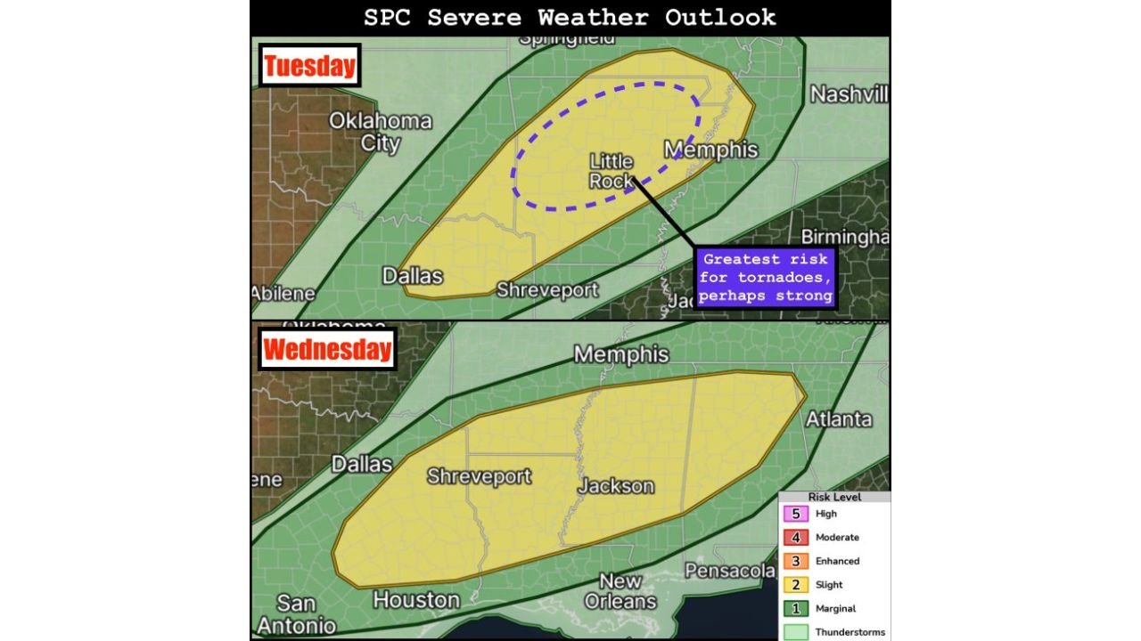
Tuesday: The Tornado Day
A Slight Risk covers a wide corridor from Oklahoma City and Dallas northeast through Little Rock, Memphis and toward Nashville, but the most dangerous zone is much more specific. A dashed purple circle on the outlook map marks where forecasters place the greatest risk for tornadoes, perhaps strong, centered directly over northern and central Arkansas near Little Rock and extending east toward Memphis, Tennessee.
Supercells are expected to develop near two separate trigger points Tuesday:
- The intersection of outflow from morning convection and the dryline in the northern Arkansas vicinity, where storms interacting with earlier convective outflow will have the highest tornado potential
- South along the dryline into northeast Texas, where additional supercell development is expected with all severe hazards possible
The outflow interaction in northern and central Arkansas is the critical wildcard. When mature supercells encounter boundaries left by earlier morning storms, tornado probability increases dramatically and storms can produce tornadoes with very little warning.
Wednesday: The Wind and Hail Day
Wednesday’s setup shifts south with a Slight Risk zone dropping from Memphis southwest through Shreveport, Jackson, New Orleans and Houston. The threat profile is meaningfully different from Tuesday.
Damaging winds are the greatest threat as widespread convection fires along a southward-advancing cold front sweeping through Louisiana, Mississippi and Texas. When storms organize into a line along a cold front, individual supercell structure breaks down and the primary hazard shifts to straight-line wind damage across a broad swath rather than concentrated tornado paths.
However, large hail and tornadoes remain possible Wednesday, particularly along the dryline in Texas where discrete storm development could occur before the frontal squall line consolidates.
Two Days, Two Different Threats
| Tuesday May 5 | Wednesday May 6 | |
|---|---|---|
| Primary Hazard | Strong tornadoes | Damaging winds |
| Secondary Hazards | Large hail, damaging wind | Large hail, isolated tornado |
| Highest Risk Zone | Little Rock to Memphis | Shreveport to Jackson |
| Storm Mode | Discrete supercells | Frontal squall line |
| Trigger | Dryline plus outflow boundary | Southward cold front |
What Residents in Each Zone Should Do
Tuesday — Little Rock, Conway, Batesville, Memphis: The outflow boundary interaction in northern and central Arkansas makes Tuesday’s tornado threat particularly difficult to predict precisely. Strong tornadoes can develop rapidly when supercells encounter these boundaries. Shelter locations should be identified before Tuesday afternoon and weather alert systems should be active throughout the day.
Wednesday — Shreveport, Jackson, New Orleans, Houston: The damaging wind threat along the cold front means a large geographic area faces hazardous conditions simultaneously. Anyone in Louisiana, southern Mississippi and eastern Texas should expect gusty and potentially damaging winds with any line of storms Wednesday and should avoid being outdoors or on the road during the passage of the frontal squall line.
WaldronNews.com will continue tracking both Tuesday and Wednesday severe weather threats across Arkansas, Mississippi, Louisiana and Texas and will provide updated coverage as both events approach.