
Kansas, Oklahoma, Nebraska and Colorado Face Sharply Different 30-Day Rainfall Outlooks May 22 Through June 22 as Back to Back Model Runs Show Dramatic Forecast Shifts in Just 24 Hours
WICHITA, Kansas — Two extended precipitation forecasts run just 24 hours apart are telling dramatically different stories for Kansas, Oklahoma, Nebraska and Colorado covering the 30-day period from May 22 through June 22, 2026, highlighting just how volatile and uncertain long-range rainfall forecasts can be for the Plains region heading into early summer.
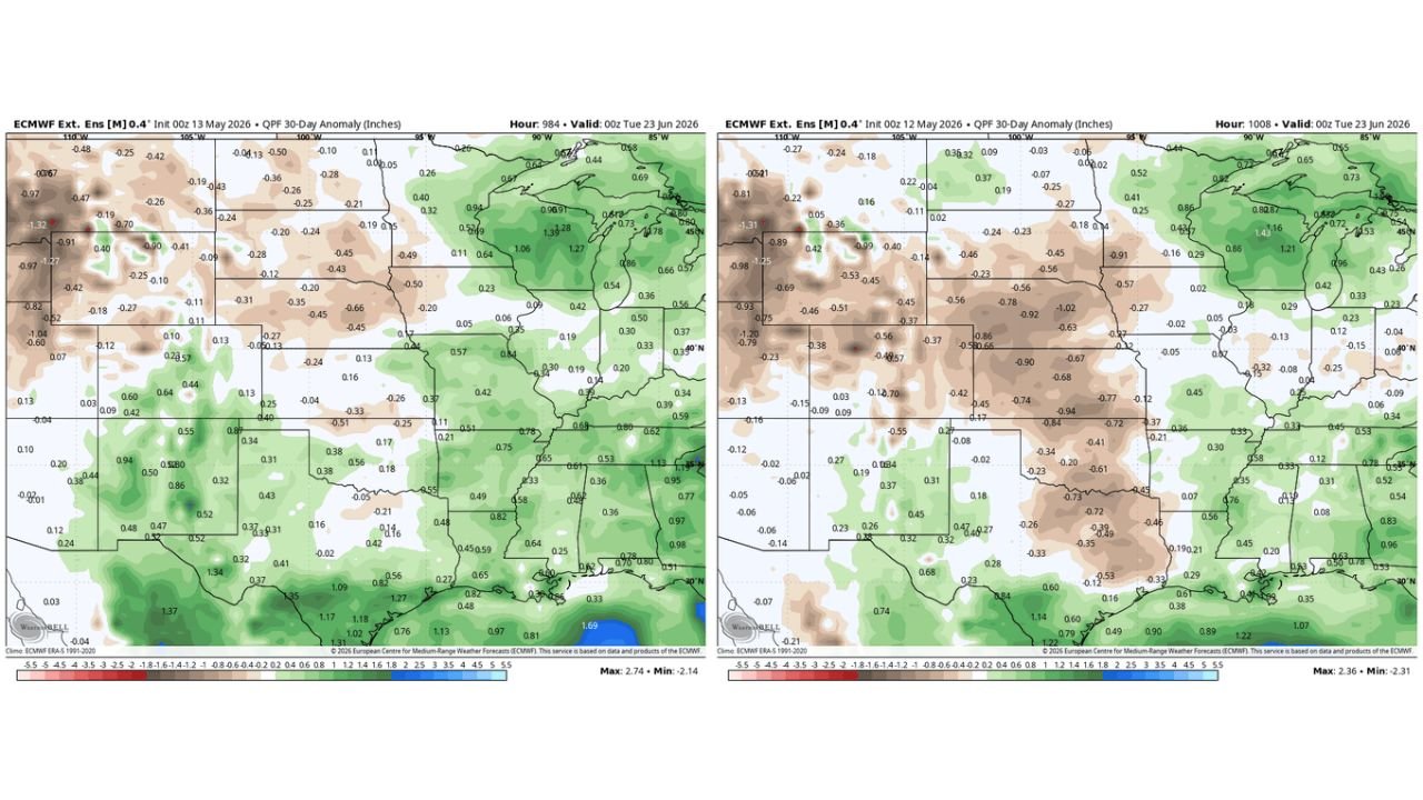
The May 13 model run paints a noticeably wetter picture for much of the central Plains compared to the drier signal that dominated the May 12 run just one day earlier.
Side by Side: What Changed in 24 Hours
This is the core of the story. Two runs of the same model. Same region. Just 24 hours apart. The difference is significant:
May 13 Run (most recent) valid through June 23:
| State/Area | Rainfall Anomaly |
|---|---|
| Southern Kansas and northern Oklahoma | +0.31 to +0.56 inches above normal |
| Central Oklahoma | +0.38 to +0.56 inches above normal |
| Eastern Colorado | +0.42 to +0.94 inches above normal |
| Southern Texas and Louisiana | +1.09 to +1.37 inches above normal |
| Western Nebraska and Wyoming | -0.20 to -0.45 inches below normal |
| Montana and northern Idaho | -0.90 to -1.32 inches below normal |
May 12 Run (previous day) valid through June 23:
| State/Area | Rainfall Anomaly |
|---|---|
| Kansas core | -0.68 to -0.94 inches below normal |
| Oklahoma | -0.41 to -0.73 inches below normal |
| Eastern Colorado | -0.02 to -0.23 inches below normal |
| Southern Texas | +0.60 to +1.14 inches above normal |
| Montana and northern Idaho | -0.93 to -1.31 inches below normal |
The shift from negative 0.68 to negative 0.94 inches in Kansas on the May 12 run to positive 0.31 to positive 0.56 inches on the May 13 run represents a dramatic reversal in the rainfall outlook for the same region in just one day.
Why This Matters for Plains Residents and Farmers
For farmers, ranchers and water managers across Kansas, Oklahoma, Nebraska and Colorado, this 24-hour forecast swing illustrates a critical point about long-range weather data.
Extended range forecasts covering 30 days into the future carry significant uncertainty. The atmosphere at these time ranges is inherently difficult to predict, and model-to-model swings of nearly 1 inch in either direction across the same region are not unusual. When a model run shows an apocalyptically dry signal it gets shared widely online. When the next day’s run reverses that signal toward wetter conditions, that update rarely gets the same attention.
Both runs agree on one thing. Montana, northern Idaho and much of the Northwest are tracking below normal rainfall through June 22 on both the May 12 and May 13 forecasts, with anomalies ranging from negative 0.90 to negative 1.32 inches across Montana in both runs. That persistent dry signal across the Northwest carries more confidence precisely because it appears consistently across multiple model runs.
What Residents Should Take From This
The honest answer for Kansas, Oklahoma and Colorado heading into the May 22 through June 22 period is that the rainfall outlook remains genuinely uncertain at this range. The wetter signal on the May 13 run is encouraging for drought-affected areas but should not be taken as a reliable forecast given how dramatically it shifted from the previous day.
Watch the 10 to 14 day forecasts for Kansas, Oklahoma and Colorado as the May 22 start date approaches. Confidence in precipitation totals increases dramatically once the forecast window shrinks to under two weeks, and that is when residents, farmers and water managers should make decisions based on the rainfall outlook.
WaldronNews.com will continue tracking extended precipitation forecasts across Kansas, Oklahoma, Nebraska and Colorado and will provide updates as the May 22 through June 22 rainfall outlook develops and model consistency improves.