
Breaking Update for Iowa and Wisconsin as Two Dangerous Supercells Flagged for Strong Tornadoes Near Manchester Iowa and Richland Center Wisconsin at 6 PM Tuesday
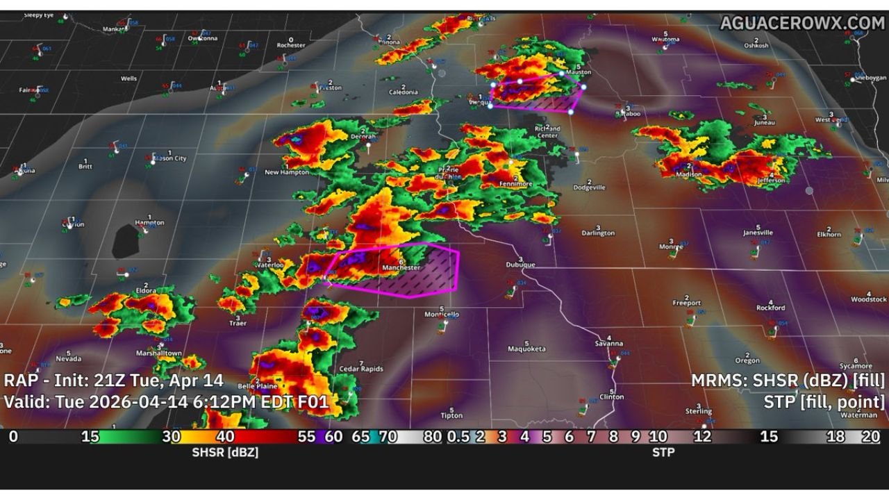
DUBUQUE, Iowa — A critical and rapidly evolving severe weather update is coming out of Iowa and Wisconsin at 6:12 PM EDT Tuesday, April 14 — while the broader Midwest storm system is upscaling too quickly and limiting the overall tornado threat across much of the region, two specific supercells have been identified and flagged in pink hatched polygons on live radar as being favorable for strong tornadoes in the short term near Manchester, Iowa and Richland Center, Wisconsin.
These two storms need to be watched with extreme urgency right now. Everything else happening across the broader Midwest storm complex is secondary — the two pink hatched supercell polygons are where the immediate tornado danger is concentrated at this moment.
What Is Happening Right Now — The Critical Update
The broader severe weather setup across the Midwest has run into a significant limiting factor in the last hour. Storms and showers are growing upscale too quickly — meaning individual thunderstorm cells are merging into a larger, more disorganized cluster rather than staying as discrete, separated supercells. When storms cluster together like this, they choke off each other’s warm inflow — the supply of warm moist air that individual supercells need to maintain their rotation and tornado-producing structure. This upscaling process is reducing the overall tornado threat across the broader Midwest storm corridor compared to what was anticipated earlier today.
However — and this is critical — two supercells have managed to stay discrete and are currently in favorable tornado environments:
The Two Flagged Supercells — Immediate Danger Zones
Supercell 1 — Manchester, Iowa Area: The first pink hatched polygon is centered near Manchester, Iowa — located in Delaware County in northeast Iowa. This supercell is showing the characteristics of a storm that is favorably positioned for strong tornado production in the near term. The pink hatching designation means this specific storm has been identified as operating in an environment where Significant Tornado Parameter values are elevated and the storm structure is favorable for rotation. Communities in the immediate path of this storm — including Manchester, Dyersville, Monticello, and the surrounding Delaware and Jones County communities — are in immediate danger and need to be sheltered now.
Supercell 2 — Richland Center, Wisconsin Area: The second pink hatched polygon is located near Richland Center, Wisconsin — in southwest Wisconsin. This storm is also identified as favorable for strong tornado production in the short term. Communities near Richland Center, Dodgeville, Prairie du Chien, and the surrounding Richland and Iowa County Wisconsin communities are in the direct threat zone for this supercell and need to take immediate shelter.
Why These Two Storms Are Dangerous Despite the Broader Limiting Factors
The fact that these two supercells have maintained their discrete structure while surrounding storms merge into a broader complex actually makes them more dangerous, not less. Discrete supercells operating in an environment where surrounding storm activity is being suppressed by upscaling can continue drawing on the available warm inflow that the broader cluster cannot access — giving them a sustained fuel supply that keeps their rotation organized and intense.
The pink hatched polygon designation is a specific and serious identification tool used during active severe weather events to alert residents to the storms with the highest immediate tornado potential. When a storm is placed inside a pink hatched polygon during an active event, that is a direct signal from experienced severe weather analysts that this specific storm deserves immediate and urgent attention above all others on the radar.
The Significant Tornado Parameter values shown on the radar — with the STP scale visible at the bottom ranging from 0.5 to 15 — confirm that the atmospheric environment in the northeast Iowa and southwest Wisconsin corridor where these two supercells are operating still contains meaningful tornado-producing potential despite the broader upscaling limiting the overall regional threat.
Communities That Must Be Sheltered Immediately
Iowa — Manchester Supercell Path:
- Manchester, Delaware County — directly under the flagged polygon
- Dyersville — in the potential storm path
- Monticello — Jones County communities in the track zone
- Dubuque area communities — monitor closely as storm tracks east
Wisconsin — Richland Center Supercell Path:
- Richland Center — directly in the flagged zone
- Dodgeville — Iowa County communities in the potential track
- Prairie du Chien — western Wisconsin communities monitoring the storm’s movement
- Madison corridor — watch for storm track updates as this supercell moves
This Situation Is Changing by the Minute
The 6:12 PM EDT radar represents a snapshot of a rapidly evolving situation. The two flagged supercells could strengthen, weaken, produce tornadoes, or merge with surrounding storm activity within the next 15 to 30 minutes — making real-time monitoring absolutely essential for anyone in the Manchester, Iowa and Richland Center, Wisconsin corridors right now.
The broader upscaling trend limiting the regional tornado threat could also reverse if storm organization improves — meaning additional supercells could emerge from the broader complex and develop tornado potential beyond just the two currently flagged storms.
What to Do Right Now — No Time to Wait
- Manchester, Iowa residents — you are under a flagged supercell polygon right now. Move to your lowest floor interior room immediately — do not wait for a tornado warning to be issued before beginning to shelter
- Richland Center, Wisconsin residents — same instruction applies. The pink hatched polygon over your area means this storm is being watched as an immediate tornado threat
- Dubuque, Dyersville, Monticello, Dodgeville, and Prairie du Chien — you are in the potential path of one of these two flagged supercells. Be in your shelter location and monitoring alerts actively right now
- Do not go outside to look for the storm — if a tornado develops from either of these supercells, it may be rain-wrapped and invisible until it is dangerously close
- Keep weather alerts active and check for tornado warnings for your specific county every few minutes as this situation evolves rapidly
- The broader Midwest storm complex continues moving east — even communities not currently under flagged polygons should remain weather-aware through the evening
Two dangerous supercells are on the radar right now near Manchester, Iowa and Richland Center, Wisconsin — and both are flagged as immediate tornado threats. Every second counts for residents in those communities.
WaldronNews.com is monitoring this rapidly evolving situation across Iowa and Wisconsin and will provide immediate updates as tornado warnings are issued and storm conditions change.