
Back to Back Tornado Outbreaks Possible Sunday and Monday as Powerful Jet Stream Targets Mississippi Valley and the Deep South
JACKSON, Mississippi — The atmosphere is setting up for something significant — and forecasters are using serious language to describe what is shaping up for Sunday April 26 and Monday April 27. A legitimate chance for back-to-back tornado outbreaks is now on the table across the Mississippi Valley and Deep South, with upper-level wind maps showing an extraordinarily powerful jet stream driving back-to-back severe weather setups on consecutive days.
The wind energy maps for both Sunday and Monday show deep purple and pink colors — the highest wind values on the scale — screaming across the central and eastern United States. That upper-level energy is the engine that turns Gulf moisture and surface instability into organized, dangerous supercells.
States Facing Back-to-Back Outbreak Potential
The two-day severe weather corridor covers the heart of the South:
- Mississippi: Jackson, Tupelo, and Meridian — sitting east of the Mississippi River where good lapse rates are flagged for Monday, directly in the path of both Sunday and Monday systems
- Alabama: Birmingham, Huntsville, and Tuscaloosa — in the warm sector for Monday’s potent setup
- Tennessee: Memphis and Nashville — inside the threat corridor both days as the jet stream races overhead
- Arkansas: Little Rock corridor — in the path of Sunday’s system
- Missouri: St. Louis and Springfield — northern edge of the Sunday severe weather zone
- Illinois and Indiana: Included in the Monday warm sector as the system expands eastward
- Kentucky: Louisville corridor on the northern fringe of Monday’s threat
What the Atmospheric Maps Are Showing
The four wind maps covering Sunday and Monday tell a powerful story:
- Sunday 500mb jet stream — a massive purple and pink wind maximum stretching from the Southern Plains through the Mid-South, providing the upper-level energy needed to organize supercells with tornado potential
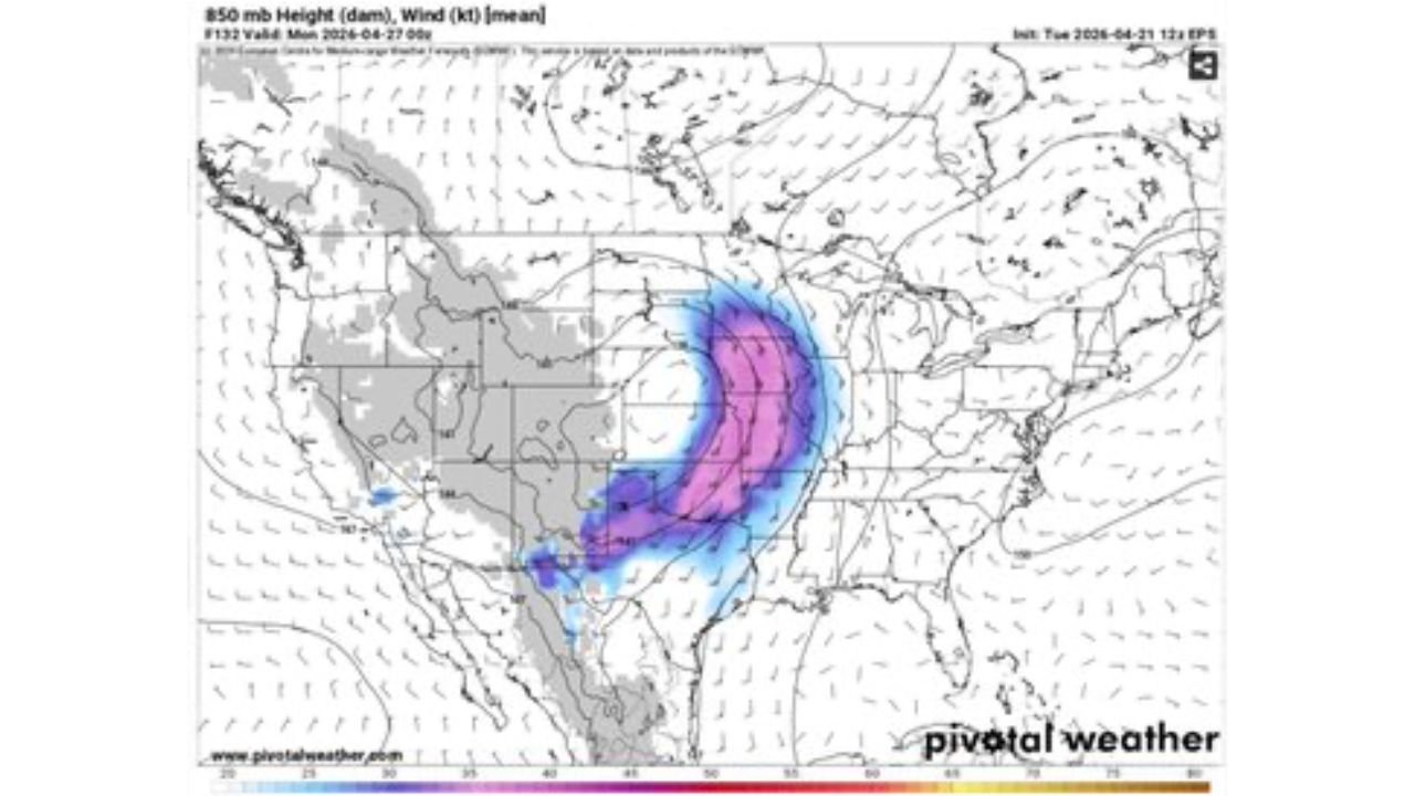
- Sunday 850mb low-level jet — a focused pink core of low-level wind energy over the Mississippi Valley and Arkansas, creating the low-level wind shear that generates tornado rotation
- Monday 500mb jet — the upper-level energy intensifies and shifts eastward, now covering Alabama, Tennessee, and the Ohio Valley with the strongest wind values
- Monday 850mb low-level jet — the low-level jet explodes eastward on Monday, with the deepest purple values now positioned directly over Alabama, Mississippi, and Tennessee — exactly where the large warm sector and good lapse rates are flagged
Why Sunday and Monday Are Both Dangerous in Different Ways
Jackson, Mississippi sits in the zone that gets hit by both systems — and understanding why each day is dangerous in its own right matters for preparation.
Sunday’s concern is specifically around what forecasters are calling a lack of deep-layer development in some atmospheric models. That means there is uncertainty about whether storms will become truly organized supercells capable of producing significant tornadoes, or whether they remain more disorganized. However, forecasters are explicitly warning this concern “should not be discounted” — meaning the tornado threat is real even if the setup is not perfectly textbook. The upper-level jet energy shown on Sunday’s maps is genuinely impressive and should not be ignored.
Monday is the more alarming day. The description of a “large warm sector and potent setup with good lapse rates east of the Mississippi River” is exactly the language used before major tornado outbreaks. Lapse rates describe how rapidly temperature drops with altitude — steep lapse rates mean the atmosphere is extremely unstable, allowing thunderstorms to explode upward rapidly and tap into the wind shear environment needed for tornado development.
Monday’s 850mb map shows the low-level jet — the atmospheric conveyor belt of moisture and rotation — shifting its deepest values directly over Alabama, Mississippi, and Tennessee. That positioning, combined with the powerful upper-level jet racing overhead, creates the classic stacked wind profile that produces violent, long-track tornadoes.
The back-to-back nature of these two days is particularly dangerous. Communities that sustain damage Sunday — downed trees, power outages, compromised structures — face all those vulnerabilities again just 24 hours later when Monday’s potentially stronger system arrives.
Multi-Day Pattern
The active severe weather stretch runs continuously from Thursday April 23 through Monday April 27 — five straight days of threats shifting progressively eastward from the Plains to the Deep South. Thursday targets Kansas and Iowa. The weekend targets Oklahoma and the Southern Plains. Sunday and Monday bring the final and potentially most dangerous chapter to the Mississippi Valley and Deep South before the pattern briefly relaxes.
What to Watch Next
- Sunday morning forecast updates — whether the deep-layer development concern resolves or confirms tornado potential
- Tornado watch issuances Sunday afternoon for Arkansas, Mississippi, and Tennessee
- Monday warm sector position — how far north the instability and lapse rates extend into Illinois and Indiana
- Whether any Sunday storms produce significant tornadoes that set the tone for Monday’s even more potent setup
- Emergency management preparation across Mississippi, Alabama, and Tennessee for back-to-back severe weather days
Residents across Mississippi, Alabama, Tennessee, Arkansas, Missouri, Illinois, and Kentucky need to treat both Sunday and Monday as serious tornado threat days. Have your shelter plan ready, know how you will receive warnings, and do not let a quiet Saturday lull you into complacency. The atmosphere is loaded for both days.
WaldronNews.com will continue tracking the Sunday and Monday outbreak potential and provide updates as both setups come into sharper focus through the week.