
Oklahoma and Kansas All-Hazards Alert Tonight as EF2+ Tornadoes and Very Large Hail Target Oklahoma City to Wichita Between 6 and 9 PM
OKLAHOMA CITY, Oklahoma — The window for dangerous severe weather is opening tonight across Oklahoma and southeast Kansas, and confidence is rising fast. Isolated supercells are expected to develop between 6 and 9 PM CDT across a corridor stretching from Lawton and Oklahoma City north through Tulsa and up toward Wichita — and these storms are capable of producing every severe weather hazard at once: very large hail, damaging straight-line winds, and EF2 or stronger tornadoes.
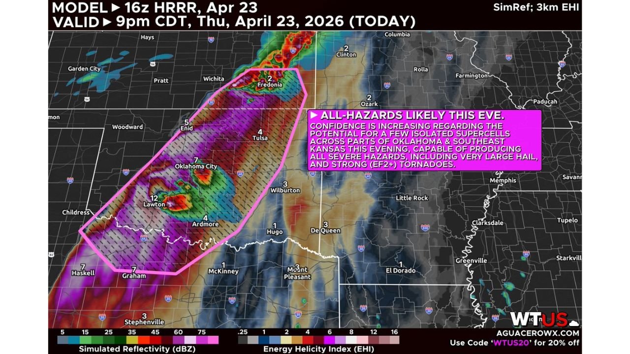
The pink-outlined zone on tonight’s simulation map covers one of the most populated corridors in the Southern Plains — and the Energy Helicity Index values running through this zone are in the range that supports significant, long-track tornado development.
Cities in Tonight’s All-Hazards Zone
- Oklahoma: Oklahoma City, Tulsa, Enid, Lawton, Ardmore, Wilburton — entire central Oklahoma corridor inside the primary threat box
- Kansas: Southeast Kansas including Fredonia, Chanute — northern extension of the supercell zone
- Texas: Graham, Childress, northern Texas Panhandle fringe — southern edge of the hatched significant tornado zone
- Arkansas: De Queen, Mena area — eastern fringe as storms potentially track overnight
Primary Threats
- EF2+ tornadoes — the hatched significant tornado zone covers the entire Oklahoma-southeast Kansas corridor; isolated supercells in this environment are capable of producing strong, long-track tornadoes
- Very large hail — all severe hazards expected with tonight’s supercells; hail threat carries over from today’s daytime storms with an even more favorable overnight shear profile
- Damaging straight-line winds — supercells tonight will also produce destructive wind gusts alongside the hail and tornado threat
- 6 to 9 PM firing window — this is the critical period; if storms develop during this timeframe, they immediately have access to a dangerous overnight environment with a strengthening low-level jet
Why This Matters for Oklahoma City and Tulsa
Tonight’s threat is different from a typical afternoon severe weather event — and that difference makes it more dangerous. Storms firing between 6 and 9 PM in this kind of atmospheric setup hit the ground running. By the time they develop, the low-level jet is already strengthening after sunset, adding rotational energy to storms that are already organized supercells. There is no gradual ramp-up period — storms can go from initiation to tornado-warned within minutes.
The Energy Helicity Index values shown on the simulation map — the color shading running from green through red inside the pink box — measure the atmosphere’s ability to produce rotating storms. Values in the range shown over Oklahoma City, Tulsa, and the corridor between them are consistent with environments that produce significant tornadoes. This is not a marginal setup dressed up to look threatening. The atmosphere is genuinely loaded tonight.
Oklahoma City sits near the center of the threat zone with Lawton and Ardmore to the south also inside the hatched area. Tulsa is on the northeastern edge. The corridor between these cities — running through Shawnee, McAlester, and Ada — is in the sweet spot where isolated supercells are most likely to organize and persist long enough to produce significant tornadoes.
The main uncertainty is whether the cap weakens enough to allow storm initiation. If storms fire cleanly between 6 and 9 PM, all hazards are on the table. If the cap holds through that window, the threat diminishes. But confidence is increasing that storms do develop — and when they do, they will have everything they need to become dangerous.
Multi-Day Pattern
Tonight’s Oklahoma-Kansas event is part of a relentless severe weather stretch across the Plains and Mid-South. After tonight’s supercells push east, the pattern reloads through the weekend for Saturday’s hail event and then again for Monday, April 27’s major tornado threat targeting Tennessee, Arkansas, and Mississippi. The atmosphere is not resting between any of these events — it is cycling through one loaded setup after another.
For Oklahoma residents, tonight and Saturday both carry significant threats before the focus shifts east early next week.
What to Watch Next
- 6 PM is the start of the critical window — be in a weather-aware mode before then, not after
- If a Tornado Warning is issued tonight, you may have very little lead time — know your shelter location right now
- Track storm initiation closely across western Oklahoma and southwest Kansas this evening — the first supercell to fire sets the tone for the entire night
- Overnight storms are possible as systems track east toward Arkansas — residents in De Queen and Mena should also stay alert
- Charge all devices now and keep weather alerts active on every phone through midnight
Residents across Oklahoma City, Tulsa, and the surrounding corridor need to be shelter-ready before 6 PM tonight — this is an all-hazards severe weather situation with EF2+ tornadoes on the table.
WaldronNews.com will continue tracking tonight’s supercell development across Oklahoma and Kansas and provide updates as storms fire this evening.