
Oklahoma and Texas Hail Day Saturday as Baseball and Softball-Sized Hailstones Target Western Oklahoma and Texas Hill Country
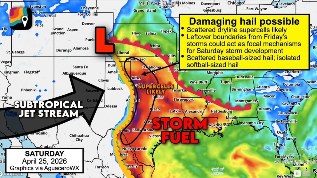
OKLAHOMA CITY, Oklahoma — Park your vehicles and stay weather-aware — Saturday, April 25 is shaping up as a significant hail day across the Southern Plains, with scattered dryline supercells capable of launching baseball to softball-sized hailstones across western Oklahoma, Texas Hill Country, and central Texas. The strongest storms today are not primarily a tornado threat — they are hail machines, and the hail they produce can total a vehicle, shatter windows, and cause serious property damage in minutes.
The greatest risk is concentrated across western Oklahoma and a corridor stretching south through the Texas Hill Country into central Texas, where supercells are most likely to fire along the dryline this afternoon.
States and Cities in the Hail Zone
Greatest Risk — Supercells Likely:
- Oklahoma: Western Oklahoma including Woodward, Altus, Lawton — highest hail threat; supercell development most likely here
- Texas: Amarillo, Lubbock, Abilene, Waco corridor — supercells likely along and east of the dryline
- Texas Hill Country: San Antonio area, Kerrville, Fredericksburg — elevated hail threat as storm fuel deepens southward
Damaging Hail Possible — Broader Zone:
- Kansas: Wichita, Liberal — southern Kansas on the northern fringe of the hail threat
- Texas: Dallas-Fort Worth, Texarkana — leftover storm boundaries from Friday could focus new development here
- Oklahoma: Oklahoma City — eastern Oklahoma inside the broader damaging hail zone
Primary Threats
- Baseball-sized hail — scattered across the supercell zone; this is the expected baseline for the strongest storms today
- Isolated softball-sized hail — possible in the most intense supercells; softball-sized hailstones cause catastrophic vehicle and roof damage
- Scattered dryline supercells — a juiced-up atmosphere loaded with storm fuel is supporting discrete supercell development; these storms are extremely efficient hail producers
- Leftover storm boundaries from Friday acting as focal points — boundaries from yesterday’s storms can trigger new supercell development in unexpected locations even outside the primary dryline zone
- Damaging winds possible with the strongest supercells alongside the hail threat
Why This Matters for Oklahoma and Texas
Baseball-sized hail is 2.75 inches in diameter. Softball-sized hail reaches 4 inches or more. To put that in perspective — a softball-sized hailstone falls at roughly 100 mph and carries enough force to punch through car hoods, shatter windshields completely, and cause structural damage to roofs in seconds. A single supercell can lay down a hail swath miles wide, and vehicles caught outside in that path face total loss.
Western Oklahoma is in the bull’s-eye today because the dryline — the boundary between dry western air and warm, moist Gulf air — is positioned to fire storms directly over this region as afternoon heating peaks. The atmosphere is described as “juiced up” with plentiful instability, meaning storms that do fire will grow rapidly and tap into the deep moisture available across the warm sector.
The Texas Hill Country threat is driven by the same dryline setup pushing south. The subtropical jet stream is nudging into the region but has not fully arrived yet — which actually favors large hail production over tornado production today, because the wind shear profile supports tall, hail-generating storm towers more than it supports the low-level rotation needed for strong tornadoes.
Dallas-Fort Worth and Texarkana face a secondary threat from leftover storm boundaries. When yesterday’s storms dissipate, they leave behind invisible boundaries in the atmosphere that can act like mini-drylines — focusing new storm development along their paths. These boundary-triggered storms are harder to predict in advance but can produce significant hail even outside the primary supercell zone.
Multi-Day Pattern
Saturday’s hail threat is the opening act of a severe weather-loaded week across the Plains and South. After today’s dryline supercells push east tonight, the atmosphere reloads through the weekend for Monday, April 27 — a significantly more dangerous event targeting Tennessee, Arkansas, and Mississippi with a tornado-focused outbreak. The same large-scale pattern powering today’s hail storms is building toward that Monday event.
For Oklahoma and Texas, today is about hail. By Monday, the threat center shifts east with tornadoes becoming the primary concern. Residents across the region should understand this is a multi-day, multi-hazard severe weather week.
What to Watch Next
- Get vehicles under cover right now — baseball and softball hail gives almost no time to react once a warning is issued
- Primary storm firing window is this afternoon through early evening — watch for the dryline to become active as surface heating peaks
- Leftover boundaries from Friday make storm initiation possible even before the main dryline fires — stay alert through the entire afternoon
- If a Severe Thunderstorm Warning is issued for your county today, assume large hail is incoming and move indoors immediately
- Begin watching Monday’s tornado threat for the Mid-South — that event follows just 48 hours behind today’s storms
Residents across Oklahoma and Texas should treat this Saturday as a serious property-damage threat — get your vehicles sheltered and stay ready to move indoors the moment storms approach.
WaldronNews.com will continue tracking today’s hail-producing supercells across Oklahoma and Texas and provide updates as storms develop this afternoon.